Photo: Wikipedia
Strategic Assessment of Bowie County
Workable tactical position. Some exposure to population density or targets, but generally defensible in a crisis.
What does the Strategic Assessment tell us?
Our Strategic Assessment grades tactical survivability of an area. Major population centers, military targets, fallout zones, natural disasters, and border exposure all drive risk — lower exposure means a more defensible position in a crisis.
This is heavily inspired by Joel Skousen's Strategic Relocation book. Highly recommended you checkout the book ($)What does this tell us?
Our Strategic Assessment grades tactical survivability of an area. Major population centers, military targets, fallout zones, natural disasters, and border exposure all drive risk — lower exposure means a more defensible position in a crisis.
This is heavily inspired by Joel Skousen's Strategic Relocation book. Highly recommended you checkout the book ($)Strategic Pillars

Key Distances
Strategic Assessment Analysis
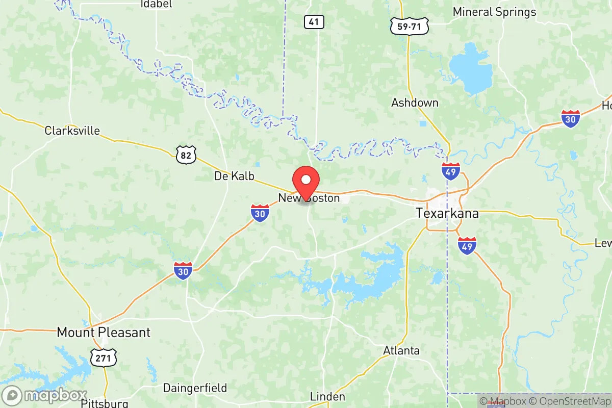
Bowie County, Texas, sits in a unique strategic position that offers genuine resilience advantages for those looking to get serious about preparedness, but it comes with trade-offs that demand clear-eyed assessment. Anchored by the twin cities of Texarkana (which straddles the Texas-Arkansas line) and surrounded by the piney woods of the Ark-La-Tex region, this county provides a blend of rural buffer and logistical access that few other Texas border counties can match. For the conservative-minded relocator who sees the writing on the wall—whether it’s civil unrest, supply chain collapse, or larger-scale disasters—Bowie County offers a credible base of operations, provided you understand its vulnerabilities and plan accordingly.
Geographic position and natural advantages for long-term security
Bowie County’s location is its strongest card. It sits roughly 150 miles northeast of Dallas and about 180 miles southwest of Little Rock, placing it outside the immediate blast radius of major metropolitan targets while still within a day’s drive of essential resources. The county is part of the Piney Woods ecoregion, which means abundant timber for construction, fuel, and cover, plus a reliable water supply from the Red River along its northern border and the Sulphur River to the south. The terrain is rolling hills and dense forest—not mountainous, but enough to provide natural concealment and defensible positions for a well-chosen homestead. The climate is humid subtropical, with hot summers and mild winters, which supports year-round gardening and livestock grazing. For a prepper, this means you can realistically aim for food self-sufficiency without fighting desert conditions or extreme cold. The county’s population density is low outside Texarkana—roughly 93,000 total residents, with most concentrated in the urban core—leaving vast stretches of rural land where a family can operate under the radar.
Risks, exposures, and proximity to fallout-relevant landmarks
Here’s where the analysis gets sobering. Bowie County’s strategic value is undercut by its proximity to several high-value targets that could become fallout zones in a major conflict or terrorist event. The most obvious is the Red River Army Depot, located just south of Texarkana in neighboring Miller County, Arkansas. This is a massive ammunition storage and demilitarization facility—a prime target for any adversary looking to cripple U.S. logistics. A strike there could scatter toxic debris and unexploded ordnance across the region, and prevailing winds would push fallout directly over Bowie County. Additionally, the county lies within a few hundred miles of Houston’s refinery corridor and the Louisiana chemical plants along the Mississippi River, both of which are high on any enemy target list. While Bowie County itself isn’t a primary target, the secondary effects—refugee flows, supply disruptions, and airborne contaminants—are real concerns. The Union Pacific rail line running through Texarkana also makes the area a chokepoint for national freight; in a crisis, that rail yard could become a magnet for looting or military seizure. On the natural disaster front, the county is in Tornado Alley’s southern fringe, with a moderate risk of severe storms, but it’s not in a hurricane zone or earthquake belt, which is a net positive.
Practical resilience for a relocator: food, water, energy, and defensibility
For the individual or family serious about self-reliance, Bowie County offers a workable foundation. Water is the first priority, and the county has ample groundwater—the Carrizo-Wilcox Aquifer underlies much of the area, providing reliable well water at depths of 100-300 feet. Surface water from the Red River is also available, though it requires treatment due to agricultural runoff. For food, the growing season runs from March to November, allowing for two crop cycles of staples like corn, beans, and squash. Local soil is sandy loam, which drains well but needs amendment—composting and cover cropping are standard practices here. Livestock options include cattle, goats, and poultry, with ample pastureland in the southern and eastern parts of the county. Energy resilience is more challenging: the grid is served by Southwestern Electric Power Company (SWEPCO), which has a mixed record on outages during ice storms. Solar is viable—the county gets about 215 sunny days per year—but you’ll want battery storage and a backup generator, preferably diesel or propane, given the region’s occasional winter freezes. Defensibility is where Bowie County shines for those who choose the right parcel. The dense pine forests provide natural cover and sound dampening, and the rural road network (mostly county roads and farm-to-market routes) offers multiple egress options. The Wright Patman Lake area, about 15 miles southwest of Texarkana, is particularly attractive: it’s sparsely populated, has water access, and is far enough from the interstate to discourage casual traffic. That said, the county’s proximity to Interstate 30 and U.S. Highway 59 means that in a crisis, you’ll see heavy refugee flow from Dallas and Shreveport. A property set back at least a mile from major roads is non-negotiable.
The overall strategic picture for Bowie County is one of guarded optimism for the prepared relocator. It’s not a perfect redoubt—the Red River Army Depot and the rail chokepoint are genuine liabilities, and the refugee risk from I-30 is real. But for a conservative-minded individual or family who wants to be out of the blast zone of major cities while still having access to medical care (Texarkana has two hospitals), supply runs, and a like-minded community, it’s a solid bet. The county’s political leanings are reliably conservative—Bowie County voted +38 points for Trump in 2020—which means local governance and social norms align with self-reliance, gun rights, and minimal interference. If you’re willing to invest in off-grid water and power, choose a defensible parcel away from the interstate, and maintain a low profile, Bowie County can serve as a long-term base for weathering whatever comes. Just don’t expect to be completely isolated—the Ark-La-Tex region is a crossroads, and in a crisis, that cuts both ways.
* Values derived from national, state, county, city and local statistics and may differ in a specific area. Last updated: 2026-05-27T18:11:40.000Z
Narrative content on this page is AI-generated and may contain mistakes. Verify any details that matter before acting on them.
ReloMaps may earn a commission from affiliate links at no extra cost to you.