Photo: Wikipedia
Strategic Assessment of Arvada, CO
Multiple tactical vulnerabilities. Population density, target proximity, or disaster risk are likely compounding. A retreat property and exit planning is required.
What does the Strategic Assessment tell us?
Our Strategic Assessment grades tactical survivability of an area. Major population centers, military targets, fallout zones, natural disasters, and border exposure all drive risk — lower exposure means a more defensible position in a crisis.
This is heavily inspired by Joel Skousen's Strategic Relocation book. Highly recommended you checkout the book ($)What does this tell us?
Our Strategic Assessment grades tactical survivability of an area. Major population centers, military targets, fallout zones, natural disasters, and border exposure all drive risk — lower exposure means a more defensible position in a crisis.
This is heavily inspired by Joel Skousen's Strategic Relocation book. Highly recommended you checkout the book ($)Strategic Pillars

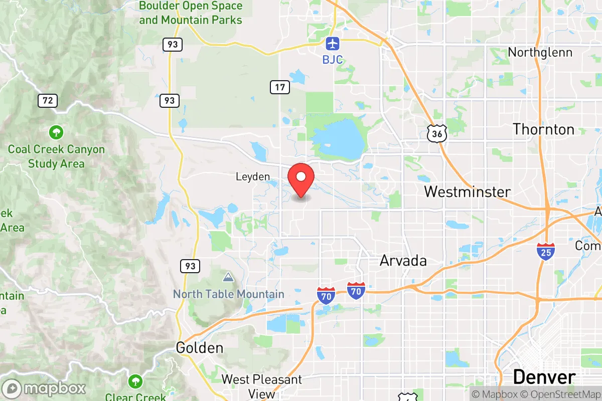
Key Distances
Regional Safe Places
Below is our recommended "safe zones" in Colorado and the surrounding area based on our strategic heuristics. For most people, it's unrealistic to live in a “safe zone” full-time due to work, family or other personal reasons. They tend to be more rural. However, many of these areas are perfect for second homes and retreat properties that double as a vacation home or even a short-term rental.


Important Note: For informational purposes only. This does not mean nothing bad ever happens in the green zones. Please use common sense. This is based on public data and modeled with AI. We tried to take a conservative approach but mistakes happen. We update this regularly as new information becomes available.
Solar Generator Recommendations
Backup power matters more here than in safer locations. We've picked three solar generators across budgets and capacity tiers — start with the budget unit if you only need a few essentials, or step up if you want to run a fridge and HVAC for days at a time.

Jackery Portable Power Station Explorer 300
Budget OptionPower on the Go: Weighing only 11 lbs, it's convenient to set up and store with book-sized foldable solar panels

BLUETTI Portable Power Station AC180
Designed for both indoor and outdoor scenarios, AC180 is highly capable as it has a robost capacity and continuous output power.

EF ECOFLOW DELTA Pro Ultra Power Station
Upgraded PickEcoFlow DELTA Pro Ultra is a whole-home energy system designed to grow with your family. Integrated with the Smart Home Panel 2, it scales to meet your evolving energy needs — keeping your home powered, intelligent, and secure through every stage of life.
We earn a commission, at no additional cost to you.
Strategic Assessment Analysis
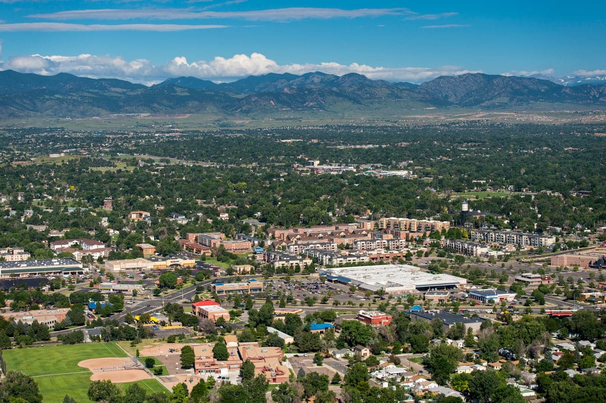
Arvada, Colorado, presents a mixed strategic picture for the conservative prepper or survivalist. Its primary advantage is its position on the western edge of the Denver metro area, offering a buffer from the immediate chaos of a major urban collapse while still providing access to critical supply chains and medical infrastructure. However, this same proximity to a population center of over 2.8 million people, combined with its location near key military and transportation hubs, introduces significant risks that must be weighed carefully. For the relocator prioritizing long-term resilience, Arvada is a compromise—not a fortress, but a defensible staging ground if you understand its vulnerabilities.
Geographic Position and Natural Advantages for a Prepper
Arvada sits at the confluence of the High Plains and the Rocky Mountain foothills, roughly 10 miles northwest of downtown Denver. This elevation—around 5,300 feet—provides a natural vantage point and a climate that is generally dry and sunny, reducing the risk of mold, rot, and pest infestations that plague wetter regions. The area is flanked by the Rocky Flats National Wildlife Refuge to the west and the sprawling Jefferson County open spaces, which offer limited but real opportunities for hunting, foraging, and off-grid movement if necessary. The South Platte River and Clear Creek run through or near the city, providing a surface water source that, with proper filtration, could supplement municipal supplies during a prolonged outage. For the survivalist, the key natural advantage is the proximity to the Front Range's mountain escape routes—Highway 93 and Highway 72 lead west into the foothills and national forests, offering a potential egress path if Denver becomes untenable. However, these same routes are choke points that would be clogged during a mass evacuation, so pre-positioning supplies and having multiple exit strategies is non-negotiable.
Risks, Exposures, and Proximity to Fallout-Relevant Landmarks
Arvada's most glaring vulnerability is its location relative to high-value targets. The city lies less than 10 miles east of the former Rocky Flats Plant, a former nuclear weapons production facility that, while now a wildlife refuge, still contains buried plutonium contamination and is a potential target for symbolic or environmental terrorism. More critically, Arvada is within the blast and fallout radius of several military and infrastructure assets: Buckley Space Force Base (30 miles southeast), the Denver Federal Center (15 miles south), and the sprawling rail and highway junctions that serve the Denver metro area. In a major conflict or terrorist event, these are primary targets. The city itself is crisscrossed by major highways (I-70, I-76, US-36) and rail lines that would become evacuation routes or military movement corridors, turning Arvada into a potential bottleneck. For the prepper, the risk of cascading failures from a Denver-area disaster—whether a dirty bomb, EMP, or civil unrest—is high. The population density of roughly 4,000 people per square mile means that even a localized event could trigger panic and resource competition. The nearby Rocky Mountain Metropolitan Airport (Jeffco) is a general aviation hub that could be commandeered by government or relief agencies, but it also represents a noise and security concern.
Practical Resilience for a Relocator: Food, Water, Energy, and Defensibility
For the individual or family looking to establish a resilient household in Arvada, the practical challenges are significant but manageable with planning. Water is the most immediate concern. The city's municipal supply comes from Denver Water and local reservoirs, but a multi-day outage would leave residents dependent on stored water or the South Platte River, which requires heavy filtration due to agricultural and urban runoff. A 55-gallon drum per person, plus a high-quality Berkey or similar filter, is the minimum. Food resilience is better: Arvada has a strong local farming history, with several community gardens and farmers' markets, but the growing season is short (May to September), and the soil is alkaline clay. A greenhouse or hydroponic setup is almost mandatory for year-round production. Energy is a mixed bag. The area gets over 300 days of sun per year, making solar panels a viable option, but the city's building codes and HOA restrictions can be hostile to visible installations. Battery backup and a generator (with fuel storage) are more practical for most homes. Defensibility is the weakest link. Arvada's suburban layout—with cul-de-sacs, large lots, and some older homes with basements—offers moderate defensibility against small-scale threats, but the lack of natural barriers and the proximity to major roads make it vulnerable to roving groups during a collapse. A home on the western edge, near the foothills, with a clear line of sight to approach routes, is far preferable to a tract home in a dense subdivision. The local police and fire response times are good (under 10 minutes in most areas), but during a widespread event, you cannot rely on them.
The overall strategic picture for Arvada is one of calculated risk. It is not a bug-out location or a self-sufficient homestead, but it can serve as a viable base for a prepared individual or family who understands the trade-offs. The proximity to Denver provides access to medical care, specialized supplies, and a larger community of like-minded preppers, but it also means you are living in the shadow of a major urban center that could become a liability. For the conservative relocator who values community, infrastructure, and a moderate climate, Arvada offers a workable middle ground—provided you have a solid plan for water, energy, and egress, and you accept that your resilience is tied to your ability to stay off the grid and out of the chaos when the balloon goes up. If you are looking for a remote mountain retreat, look farther west. If you want a place to hunker down and ride out the storm while still being able to work in the city, Arvada is worth a hard look.
* Values derived from national, state, county, city and local statistics and may differ in a specific area. Last updated: 2026-05-02T00:49:28.000Z
Narrative content on this page is AI-generated and may contain mistakes. Verify any details that matter before acting on them.
ReloMaps may earn a commission from affiliate links at no extra cost to you.