
Photo: Wikipedia
Strategic Assessment of Bettendorf, IA
Meaningful friction. Expect exposure to either population pressure, blast zones, or natural disaster risk. Consider buying a retreat property.
What does the Strategic Assessment tell us?
Our Strategic Assessment grades tactical survivability of an area. Major population centers, military targets, fallout zones, natural disasters, and border exposure all drive risk — lower exposure means a more defensible position in a crisis.
This is heavily inspired by Joel Skousen's Strategic Relocation book. Highly recommended you checkout the book ($)What does this tell us?
Our Strategic Assessment grades tactical survivability of an area. Major population centers, military targets, fallout zones, natural disasters, and border exposure all drive risk — lower exposure means a more defensible position in a crisis.
This is heavily inspired by Joel Skousen's Strategic Relocation book. Highly recommended you checkout the book ($)Strategic Pillars

Key Distances
Regional Safe Places
Below is our recommended "safe zones" in Iowa and the surrounding area based on our strategic heuristics. For most people, it's unrealistic to live in a “safe zone” full-time due to work, family or other personal reasons. They tend to be more rural. However, many of these areas are perfect for second homes and retreat properties that double as a vacation home or even a short-term rental.


Important Note: For informational purposes only. This does not mean nothing bad ever happens in the green zones. Please use common sense. This is based on public data and modeled with AI. We tried to take a conservative approach but mistakes happen. We update this regularly as new information becomes available.
Solar Generator Recommendations
Backup power matters more here than in safer locations. We've picked three solar generators across budgets and capacity tiers — start with the budget unit if you only need a few essentials, or step up if you want to run a fridge and HVAC for days at a time.

Jackery Portable Power Station Explorer 300
Budget OptionPower on the Go: Weighing only 11 lbs, it's convenient to set up and store with book-sized foldable solar panels

BLUETTI Portable Power Station AC180
Designed for both indoor and outdoor scenarios, AC180 is highly capable as it has a robost capacity and continuous output power.

EF ECOFLOW DELTA Pro Ultra Power Station
Upgraded PickEcoFlow DELTA Pro Ultra is a whole-home energy system designed to grow with your family. Integrated with the Smart Home Panel 2, it scales to meet your evolving energy needs — keeping your home powered, intelligent, and secure through every stage of life.
We earn a commission, at no additional cost to you.
Strategic Assessment Analysis
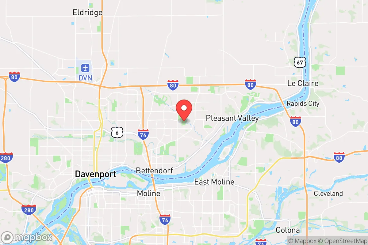
Bettendorf, Iowa, presents a mixed strategic picture for the conservative prepper. Its location along the Mississippi River offers genuine resource advantages, but its proximity to the Quad Cities metroplex and a major interstate corridor introduces significant vulnerabilities. For a relocator prioritizing long-term resilience, Bettendorf is best understood as a location with solid foundational advantages that are increasingly offset by the risks of being a secondary target zone in a national crisis scenario.
Geographic position and natural advantages for long-term survival
Bettendorf sits on the eastern edge of Iowa, directly across the Mississippi from Moline and Rock Island, Illinois. This riverine position is the area’s single greatest natural asset. The Mississippi provides a massive, reliable freshwater source for drinking, irrigation, and sanitation—something that becomes critical when municipal water treatment falters. The surrounding Scott County terrain is relatively flat, with fertile black soil that supports serious agricultural production. The climate is continental, with cold winters that can be harsh but also serve as a natural check on pest populations and disease vectors. The area is far enough inland to be insulated from hurricane storm surge and coastal flooding, and it sits outside the highest-risk tornado alleys of the central plains. While tornadoes do occur, the frequency and intensity are lower than in Oklahoma or Kansas. The region’s bedrock geology is stable, with no significant earthquake risk. For a relocator thinking in decades, the Quad Cities area offers a moderate climate, abundant water, and arable land—three pillars of any long-term survival strategy.
Risks, exposures, and proximity to fallout-relevant landmarks
The most glaring vulnerability is Bettendorf’s position within the Quad Cities metropolitan area, which has a combined population of roughly 380,000. In a scenario of civil unrest, mass casualty events, or supply chain collapse, this population base becomes a liability. The area is bisected by Interstate 80, a major east-west artery that connects the East Coast to the West Coast. In a crisis, I-80 will become a chokepoint and a target for both refugees and organized groups seeking to control movement. Bettendorf is also within 150 miles of the Chicago metro area (over 9 million people), meaning that any large-scale evacuation from that region will push directly west along I-80. The city itself is home to the John Deere World Headquarters, a facility that could become a target for sabotage or looting in a breakdown scenario. Additionally, the Quad Cities are within 200 miles of several nuclear power plants—the Quad Cities Nuclear Generating Station is just 20 miles north in Cordova, Illinois. While a meltdown is unlikely, the proximity to a major nuclear facility is a real concern for fallout exposure. Bettendorf is also within 300 miles of the nation’s strategic nuclear forces at Offutt Air Force Base in Nebraska, making it a potential secondary fallout zone in a major conflict. For the prepper, these factors mean that Bettendorf is not a remote sanctuary; it is a suburban node on a high-risk transportation corridor.
Practical resilience for a relocator: food, water, energy, and defensibility
On the practical side, Bettendorf offers several genuine advantages for a prepared individual or family. The Mississippi River provides an almost unlimited water source, but it requires treatment—boiling, filtration, or chemical purification—before consumption. The local water table is high, meaning shallow wells can be viable in many parts of Scott County, though suburban lots may have restrictions. The surrounding farmland means that local food production is feasible, and the area has a strong tradition of farmers’ markets and small-scale agriculture. For energy, the region is served by MidAmerican Energy, which has a mix of coal, natural gas, and wind. Solar potential is moderate—Iowa gets about 200 sunny days per year, which is workable but not ideal for full off-grid reliance. Wood heating is a realistic option, given the abundance of hardwood forests along the river bluffs. Defensibility is the weak point. Bettendorf is a typical suburban grid of cul-de-sacs and arterial roads, with no natural chokepoints or elevated terrain to control approach. The city is flat and open, making it difficult to secure a perimeter. A better strategic choice would be a rural property 20–30 minutes outside the metro area, where you can control access and have space for a garden, livestock, and rainwater catchment. Within Bettendorf itself, a home with a basement, a backup generator, and a well-stocked pantry is the minimum for a 30-day scenario. For longer-term collapse, the suburbs become a liability—too many neighbors, too few resources, and too many roads leading in.
The overall strategic picture for Bettendorf is one of calculated trade-offs. The area offers genuine natural advantages—abundant water, fertile soil, and a moderate climate—that make it a viable base for a prepared relocator. But those advantages are increasingly offset by the risks of being embedded in a mid-sized metro area on a major interstate corridor, within striking distance of Chicago and a nuclear power plant. For the conservative prepper who values community, local governance, and a slower pace of life, Bettendorf can work—but only if you treat it as a hub, not a fortress. The smart move is to secure a rural property within a 30-minute drive, maintain a low profile, and build relationships with like-minded neighbors. Bettendorf itself is not a survival destination; it is a starting point for a more deliberate, decentralized strategy. If you are looking for a place to ride out a short-term disruption, it will do. If you are planning for a multi-year breakdown, look further west, deeper into Iowa, where the population density drops and the land opens up.
* Values derived from national, state, county, city and local statistics and may differ in a specific area. Last updated: 2026-04-30T03:07:05.000Z
Narrative content on this page is AI-generated and may contain mistakes. Verify any details that matter before acting on them.
ReloMaps may earn a commission from affiliate links at no extra cost to you.