Photo: Wikipedia
Strategic Assessment of Carson City, NV
Workable tactical position. Some exposure to population density or targets, but generally defensible in a crisis.
What does the Strategic Assessment tell us?
Our Strategic Assessment grades tactical survivability of an area. Major population centers, military targets, fallout zones, natural disasters, and border exposure all drive risk — lower exposure means a more defensible position in a crisis.
This is heavily inspired by Joel Skousen's Strategic Relocation book. Highly recommended you checkout the book ($)What does this tell us?
Our Strategic Assessment grades tactical survivability of an area. Major population centers, military targets, fallout zones, natural disasters, and border exposure all drive risk — lower exposure means a more defensible position in a crisis.
This is heavily inspired by Joel Skousen's Strategic Relocation book. Highly recommended you checkout the book ($)Strategic Pillars

Key Distances
Regional Safe Places
Below is our recommended "safe zones" in Nevada and the surrounding area based on our strategic heuristics. For most people, it's unrealistic to live in a “safe zone” full-time due to work, family or other personal reasons. They tend to be more rural. However, many of these areas are perfect for second homes and retreat properties that double as a vacation home or even a short-term rental.
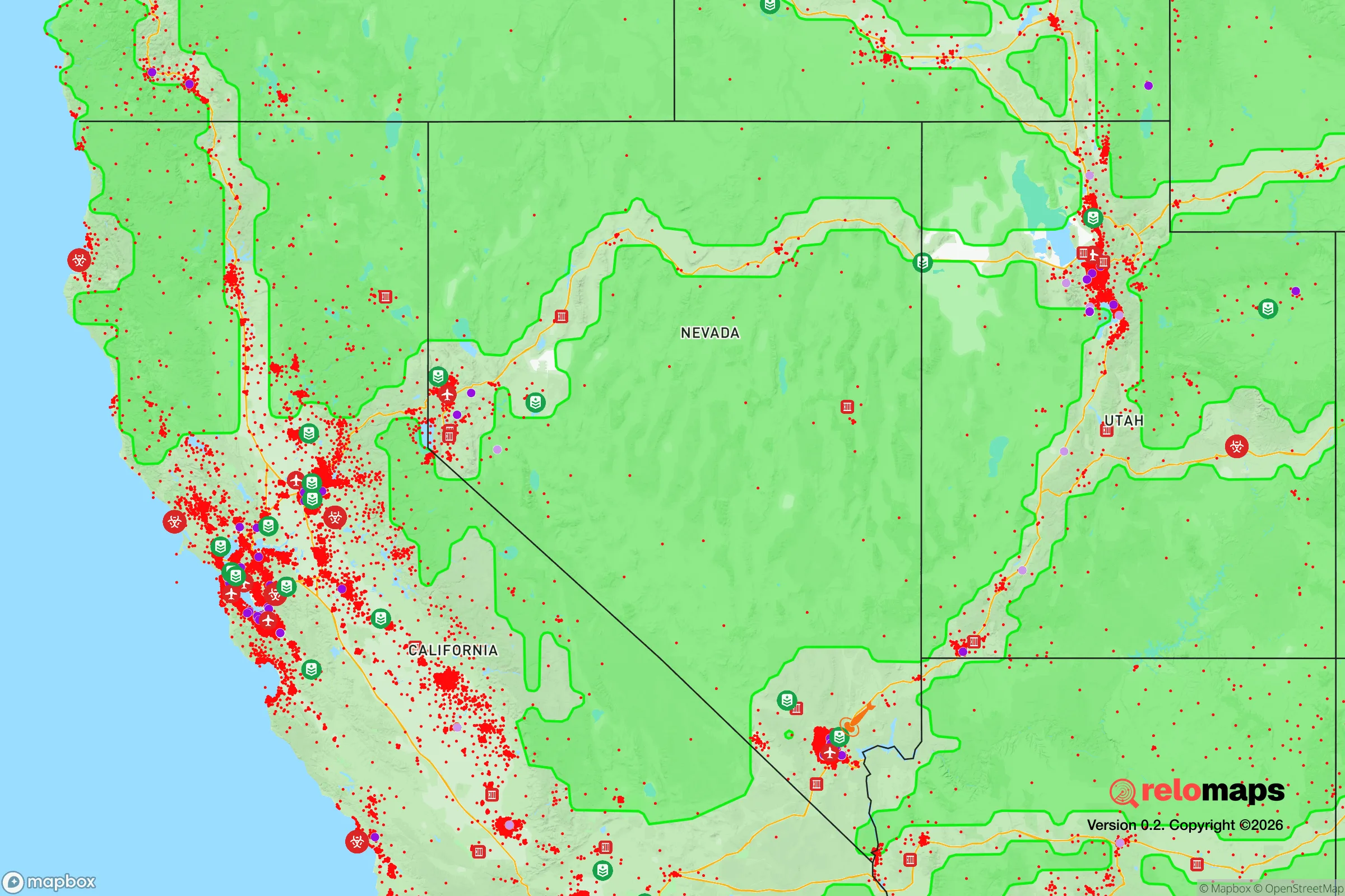
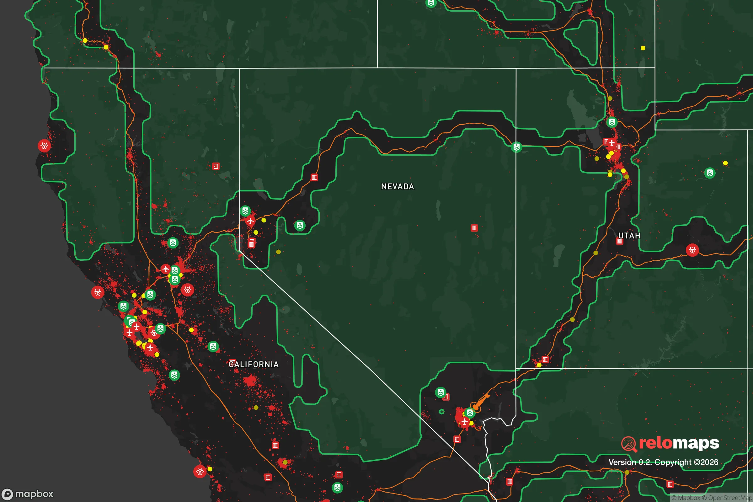
Important Note: For informational purposes only. This does not mean nothing bad ever happens in the green zones. Please use common sense. This is based on public data and modeled with AI. We tried to take a conservative approach but mistakes happen. We update this regularly as new information becomes available.
Solar Generator Recommendations
Backup power matters more here than in safer locations. We've picked three solar generators across budgets and capacity tiers — start with the budget unit if you only need a few essentials, or step up if you want to run a fridge and HVAC for days at a time.

Jackery Portable Power Station Explorer 300
Budget OptionPower on the Go: Weighing only 11 lbs, it's convenient to set up and store with book-sized foldable solar panels

BLUETTI Portable Power Station AC180
Designed for both indoor and outdoor scenarios, AC180 is highly capable as it has a robost capacity and continuous output power.

EF ECOFLOW DELTA Pro Ultra Power Station
Upgraded PickEcoFlow DELTA Pro Ultra is a whole-home energy system designed to grow with your family. Integrated with the Smart Home Panel 2, it scales to meet your evolving energy needs — keeping your home powered, intelligent, and secure through every stage of life.
We earn a commission, at no additional cost to you.
Strategic Assessment Analysis
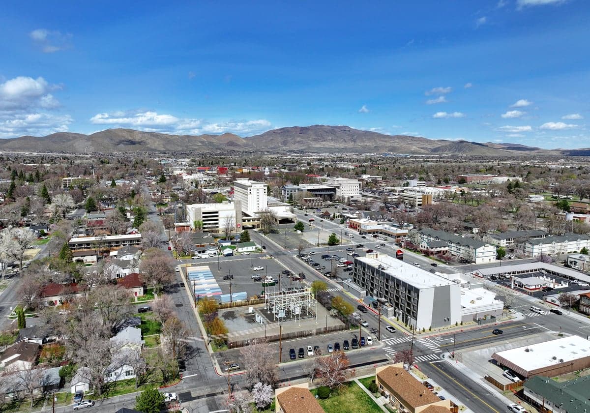
Carson City, Nevada, presents a mixed strategic picture for the conservative prepper or survivalist. Its primary resilience advantage is its position as a small, independent state capital far from the major coastal population centers, yet its proximity to the Sierra Nevada and the broader Lake Tahoe region offers both natural resources and a potential escape corridor. However, the city sits within a 150-mile radius of several high-value targets, including the San Francisco Bay Area and the Nevada Test and Training Range, which introduces significant fallout and secondary disaster risks. For a relocator seeking a balance between remote self-sufficiency and access to government infrastructure, Carson City is a viable but not ideal option—requiring careful planning for both natural and man-made threats.
Geographic position and natural advantages for long-term survival
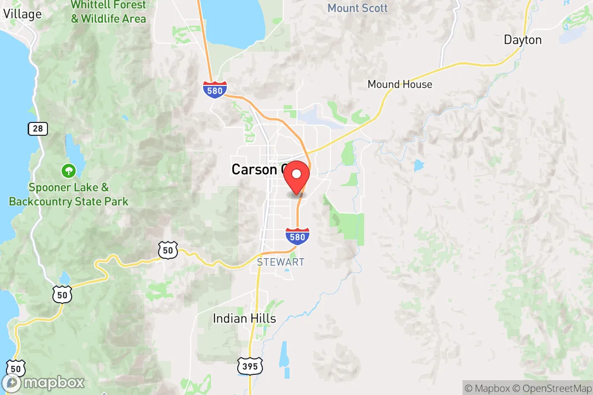
Carson City’s location in the Eagle Valley, at the base of the Carson Range, provides a defensible basin with multiple egress routes. The city is roughly 30 miles south of Reno and 15 miles east of Lake Tahoe, placing it in a corridor that connects the Great Basin to the Sierra Nevada. This geography offers reliable water sources from the Carson River and nearby mountain snowmelt, which is a critical advantage over much of the arid West. The surrounding Toiyabe National Forest and Humboldt-Toiyabe National Forest provide vast, sparsely populated areas for retreat, hunting, and foraging. The city’s elevation of 4,800 feet means a cooler, drier climate that reduces wildfire risk compared to lower-elevation Sierra foothills, though it does not eliminate it. For a relocator, the ability to move north into the remote Black Rock Desert or east into the Great Basin’s empty expanses is a strategic asset—these areas are far from major population centers and offer natural barriers to mass movement during unrest.
Risks, exposures, and proximity to fallout-relevant landmarks
The most significant risk for Carson City is its proximity to the Nevada National Security Site (NNSS), formerly the Nevada Test Site, roughly 100 miles northwest. While the NNSS is not an active nuclear testing ground, it remains a high-value target for any adversary seeking to disrupt U.S. nuclear capabilities or create a radiological event. Fallout patterns from a strike on the NNSS or from a detonation in the San Francisco Bay Area (about 200 miles west) could drift over the Sierra Nevada and affect Carson City, depending on wind direction. Additionally, the city is within 50 miles of the U.S. Navy’s Naval Air Station Fallon, a major training center for Top Gun pilots, which is a plausible target for a conventional or EMP attack. The city itself hosts the Nevada State Capitol and several state government buildings, making it a potential target for civil unrest or targeted attacks during a national crisis. The nearby Lake Tahoe Basin, while beautiful, is a tourist magnet that could become a chokepoint for refugees fleeing the California coast, creating a secondary risk of resource competition and civil disorder.
Practical resilience for a relocator: food, water, energy, and defensibility
Carson City’s practical resilience is moderate but requires active preparation. Water is the strongest asset: the Carson River flows year-round, and the city’s municipal water comes from groundwater wells and surface diversions, but a prepper should secure a private well or a rainwater catchment system, as municipal supply could be disrupted during an earthquake or grid failure. The area’s growing season is short (about 100 frost-free days), limiting large-scale agriculture, but the surrounding valleys support hay, alfalfa, and some livestock. Local food production is possible with greenhouses or cold frames, and the nearby Sierra Nevada offers game (deer, elk, and small game) and wild edibles. Energy resilience is a concern: the grid is tied to the Western Interconnection, which is vulnerable to cyberattacks and solar storms. Solar panels with battery storage are viable given the area’s 250+ sunny days per year, but winter snow can reduce output. Defensibility is decent: the city’s layout is compact, with a few main roads (U.S. 50 and U.S. 395) that can be monitored or blocked. The surrounding hills provide natural observation points, and the low population density (roughly 58,000 in the city proper) means fewer people to compete with for resources during a collapse. However, the city is not a natural fortress—its open valleys and proximity to major highways make it vulnerable to mass migration from the west.
Overall strategic picture for the conservative relocator
Carson City offers a strategic middle ground for the prepper who wants to stay within a functioning state government but avoid the chaos of a major metropolis. Its water security and access to remote federal lands are genuine advantages, but the risks from nearby military and nuclear infrastructure cannot be ignored. For a single individual or family, the city’s small size and conservative-leaning population (Nevada is a swing state, but Carson City itself leans Republican) provide a cultural buffer against the progressive policies of coastal California. The key is to establish a retreat property outside the city limits, preferably in the Pine Nut Mountains or the Sierra foothills east of Lake Tahoe, where you can leverage the natural resources while staying out of the immediate fallout zone. If you are willing to invest in off-grid water, solar, and a well-stocked pantry, Carson City can serve as a base of operations—but do not rely on it as a final redoubt. The best strategy is to treat it as a staging area for a deeper move into the Great Basin if the situation deteriorates. In short: it is a viable option for the prepared, but not a safe haven for the unprepared.
* Values derived from national, state, county, city and local statistics and may differ in a specific area. Last updated: 2026-04-22T01:26:04.000Z
Narrative content on this page is AI-generated and may contain mistakes. Verify any details that matter before acting on them.
ReloMaps may earn a commission from affiliate links at no extra cost to you.