
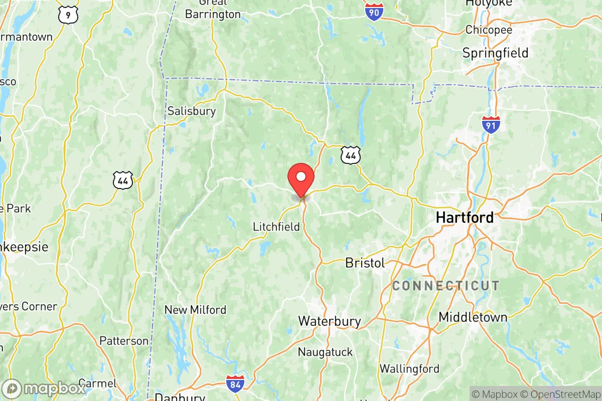
Strategic Assessment of Northwest Hills Planning Region County
Meaningful friction. Expect exposure to either population pressure, blast zones, or natural disaster risk. Consider buying a retreat property.
What does the Strategic Assessment tell us?
Our Strategic Assessment grades tactical survivability of an area. Major population centers, military targets, fallout zones, natural disasters, and border exposure all drive risk — lower exposure means a more defensible position in a crisis.
This is heavily inspired by Joel Skousen's Strategic Relocation book. Highly recommended you checkout the book ($)What does this tell us?
Our Strategic Assessment grades tactical survivability of an area. Major population centers, military targets, fallout zones, natural disasters, and border exposure all drive risk — lower exposure means a more defensible position in a crisis.
This is heavily inspired by Joel Skousen's Strategic Relocation book. Highly recommended you checkout the book ($)Strategic Pillars

Key Distances
Strategic Assessment Analysis
Northwest Hills Planning Region County, Connecticut, offers a strategic blend of geographic isolation and resource abundance that appeals to relocation-minded individuals and families prioritizing resilience and self-sufficiency. Unlike the densely populated coastal corridor running from New York to Boston, this region sits inland, shielded by the Berkshire foothills and the Litchfield Hills, providing natural separation from major metropolitan vulnerabilities. The area's low population density, abundant freshwater sources, and distance from high-value industrial and military targets make it one of the more defensible and sustainable regions in the Northeast for those thinking seriously about long-term preparedness.
Geographic position and natural advantages for disaster readiness
Northwest Hills County occupies the rugged, glaciated terrain of northwestern Connecticut, bordered by New York's Dutchess County to the west and Massachusetts's Berkshire County to the north. The region's defining feature is the Housatonic River Valley, which runs north-south through towns like Kent, Cornwall, and Sharon, providing a reliable water source and fertile bottomlands for small-scale agriculture. The surrounding hills—rising to over 1,500 feet in places—offer natural defensibility, with narrow winding roads and limited access points that would complicate any large-scale movement through the area. The region sits roughly 80 miles from New York City and 50 miles from Hartford, placing it outside the immediate blast and fallout zones of those urban centers while still being within a day's drive for supply runs or family reunification. The Appalachian Trail runs through the county's eastern edge, offering both a recreational asset and a potential backcountry evacuation corridor. The area's karst topography—limestone bedrock with natural springs and caves—provides opportunities for spring-fed water collection and underground storage that are rare in the Northeast.
Risks, exposures, and proximity to fallout-relevant landmarks
While Northwest Hills County avoids the worst of coastal hurricane surge and urban targeting, it is not without strategic vulnerabilities. The region lies within 100 miles of the Indian Point Energy Center (decommissioned but still housing spent fuel) and Millstone Nuclear Power Station in Waterford, CT, placing it within the outer plume exposure zone for a radiological release under prevailing westerly winds. The Bradley International Airport near Windsor Locks, a civilian and military cargo hub, sits roughly 50 miles east and could become a secondary target or staging area during a crisis. The county's own infrastructure is thin: Route 7 and Route 8 are the primary north-south arteries, both two-lane roads that would choke quickly under evacuation or supply disruption. The region's reliance on overhead power lines running through heavily wooded terrain makes it highly susceptible to extended winter storm outages, a recurring issue that tests local preparedness annually. There are no major refineries, ports, or military bases within the county itself, which is a net positive for avoiding direct targeting, but the New York-Newark port complex and Philadelphia refinery corridor are both within 150 miles, meaning fallout from a strike on those sites could drift into the region depending on wind patterns. The county's three small hospitals (in Sharon, Winsted, and Torrington) would be quickly overwhelmed by any regional mass casualty event, making home medical preparedness essential.
Practical resilience for a relocator: food, water, energy, and defensibility
For a family or individual serious about self-sufficiency, Northwest Hills County offers strong fundamentals. Water is abundant: the Housatonic River, its tributaries, and numerous glacial lakes (including Lake Waramaug and Bantam Lake) provide year-round surface water, and the region's high water table means shallow wells are reliable for most properties. Food production potential is moderate but real: the growing season runs roughly 150 days (May through September), suitable for cold-hardy crops like potatoes, root vegetables, apples, and hay. The county has a long tradition of small dairy and livestock farming, particularly in Cornwall and Kent, meaning local knowledge and breeding stock are available for those looking to establish a homestead. Forest cover exceeds 75%, providing ample firewood for heating and cooking, though sustainable harvesting requires acreage and tools. Energy resilience is the weak link: the grid is aging and tree-fall prone, and natural gas service is limited to the larger towns (Torrington, Winsted). Off-grid solar is viable but requires battery storage due to the region's frequent cloud cover in winter. Defensibility is high: the terrain's steep hills, stone walls, and limited road network create natural chokepoints, and the local culture of hunting and firearms ownership means a significant portion of the population is armed and trained. The county's sheriff's department and state police presence is thin, however, so community-based security networks would be essential in a prolonged crisis. Torrington, the largest town (population ~35,000), serves as the regional hub for hardware, medical supplies, and bulk goods, but its density also makes it a potential liability if civil order degrades.
Overall, Northwest Hills County presents a favorable strategic picture for the resilience-minded relocator, particularly when compared to the coastal suburbs of New York or Boston. Its primary strengths—abundant water, defensible terrain, low population density, and distance from high-value targets—are balanced by real weaknesses in grid reliability, medical infrastructure, and road network fragility. The region is best suited for those willing to invest in off-grid energy, deep pantry storage, and community relationships with local farmers and tradespeople. It is not a bug-out location for the unprepared; it is a long-term settlement zone for those who treat resilience as a lifestyle rather than a contingency. For a family or individual with the resources to establish a self-sufficient property and the discipline to maintain it, Northwest Hills County offers one of the more viable options in the Northeast for weathering both natural and man-made disruptions.
* Values derived from national, state, county, city and local statistics and may differ in a specific area. Last updated: 2026-06-12T18:07:36.000Z
Narrative content on this page is AI-generated and may contain mistakes. Verify any details that matter before acting on them.
ReloMaps may earn a commission from affiliate links at no extra cost to you.