
Photo: Philip White via Unsplash
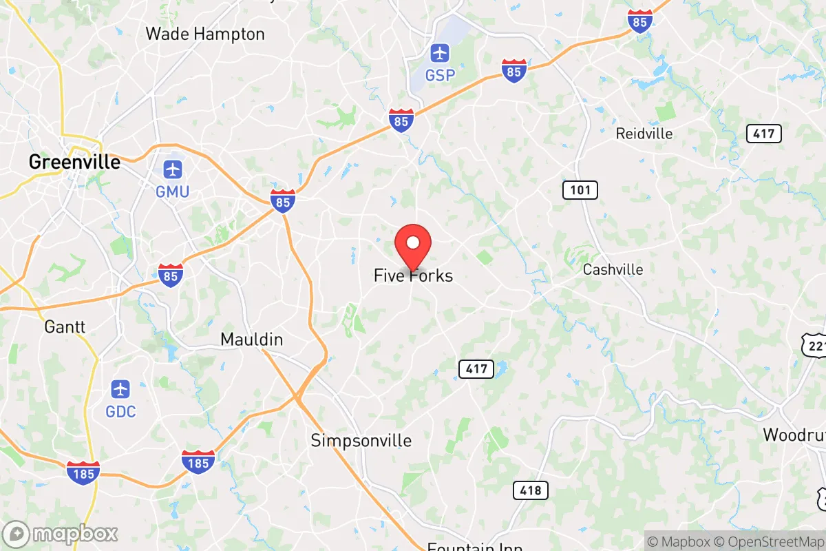
Strategic Assessment of Five Forks, SC
Workable tactical position. Some exposure to population density or targets, but generally defensible in a crisis.
What does the Strategic Assessment tell us?
Our Strategic Assessment grades tactical survivability of an area. Major population centers, military targets, fallout zones, natural disasters, and border exposure all drive risk — lower exposure means a more defensible position in a crisis.
This is heavily inspired by Joel Skousen's Strategic Relocation book. Highly recommended you checkout the book ($)What does this tell us?
Our Strategic Assessment grades tactical survivability of an area. Major population centers, military targets, fallout zones, natural disasters, and border exposure all drive risk — lower exposure means a more defensible position in a crisis.
This is heavily inspired by Joel Skousen's Strategic Relocation book. Highly recommended you checkout the book ($)Strategic Pillars

Key Distances
Regional Safe Places
Below is our recommended "safe zones" in South Carolina and the surrounding area based on our strategic heuristics. For most people, it's unrealistic to live in a “safe zone” full-time due to work, family or other personal reasons. They tend to be more rural. However, many of these areas are perfect for second homes and retreat properties that double as a vacation home or even a short-term rental.


Important Note: For informational purposes only. This does not mean nothing bad ever happens in the green zones. Please use common sense. This is based on public data and modeled with AI. We tried to take a conservative approach but mistakes happen. We update this regularly as new information becomes available.
Solar Generator Recommendations
Backup power matters more here than in safer locations. We've picked three solar generators across budgets and capacity tiers — start with the budget unit if you only need a few essentials, or step up if you want to run a fridge and HVAC for days at a time.

Jackery Portable Power Station Explorer 300
Budget OptionPower on the Go: Weighing only 11 lbs, it's convenient to set up and store with book-sized foldable solar panels

BLUETTI Portable Power Station AC180
Designed for both indoor and outdoor scenarios, AC180 is highly capable as it has a robost capacity and continuous output power.

EF ECOFLOW DELTA Pro Ultra Power Station
Upgraded PickEcoFlow DELTA Pro Ultra is a whole-home energy system designed to grow with your family. Integrated with the Smart Home Panel 2, it scales to meet your evolving energy needs — keeping your home powered, intelligent, and secure through every stage of life.
We earn a commission, at no additional cost to you.
Strategic Assessment Analysis
Five Forks, South Carolina, offers a compelling strategic position for those prioritizing resilience and long-term sustainability, combining the practical advantages of rural adjacency with the infrastructure of a growing exurban hub. Located in the northwestern corner of Greenville County, this unincorporated community sits roughly 15 miles from downtown Greenville and about 30 miles from the North Carolina border, placing it within a day's drive of major Southeastern population centers while maintaining a distinctly low-density, semi-rural character. For a relocator concerned with civic unrest, mass casualty events, or large-scale disasters, Five Forks provides a buffer zone that is close enough to access regional resources but far enough to avoid the immediate fallout of urban collapse. The area's recent growth—driven by families and professionals seeking space and relative affordability—has created a built-in community of like-minded individuals, which is a non-trivial asset when considering mutual aid and neighborhood defense in a crisis scenario.
Geographic position and natural advantages for long-term security
Five Forks sits on the Piedmont plateau, a region characterized by rolling hills, mixed hardwood and pine forests, and a temperate climate that supports year-round agriculture. The elevation here averages around 900 feet, which provides a modest but meaningful advantage over coastal areas in terms of storm surge risk and sea-level rise—a factor that becomes relevant when considering climate-driven displacement events. The area is drained by the Saluda River and its tributaries, which flow into Lake Greenwood and Lake Murray to the south, offering reliable freshwater sources that are less likely to be contaminated by industrial runoff compared to more developed watersheds. The soil, while not the richest in the Southeast, is workable for small-scale gardening and livestock grazing, and the growing season stretches from April to October, allowing for substantial food production. The Blue Ridge Escarpment lies just to the north, creating a natural barrier that slows the approach of severe weather systems and provides a defensible high-ground retreat zone if needed. For a prepper, the key takeaway is that Five Forks is not in a floodplain, not on a major fault line, and not directly in the path of hurricane storm surge—three natural disaster vectors that are increasingly problematic elsewhere in the region.
Risks, exposures, and proximity to fallout-relevant landmarks
The primary strategic vulnerability of Five Forks is its proximity to Greenville, a city of roughly 70,000 that serves as a regional economic and transportation hub. In a mass casualty event or civil unrest scenario, Greenville's population could become a source of refugee flow along major arteries like Highway 14 and Interstate 85, which pass within a few miles of the community. The I-85 corridor itself is a double-edged sword: it provides access to supply chains and evacuation routes, but it also funnels traffic from Charlotte (90 miles northeast) and Atlanta (150 miles southwest) directly past Five Forks. A more localized concern is the proximity of the Donaldson Center, a former Air Force base now used for industrial and aviation purposes, located about 10 miles southwest. While not a nuclear target in the traditional sense, any major industrial accident or terrorist event at such a facility could generate hazardous material concerns. Additionally, the Savannah River Site, a nuclear weapons facility and waste storage complex, lies roughly 100 miles to the south—close enough that a catastrophic release could affect air quality and water tables over time, though direct fallout is unlikely given prevailing wind patterns. The area's power grid is served by Duke Energy, which has a mixed reliability record during extreme weather events, and the local water supply comes from the Greenville Water System, which draws from the Table Rock Reservoir—a single-point-of-failure vulnerability that preppers should note.
Practical resilience for a relocator: food, water, energy, and defensibility
For a relocator focused on self-sufficiency, Five Forks offers a workable baseline that requires deliberate investment to reach full resilience. The housing stock is predominantly single-family homes on lots ranging from half an acre to several acres, which is sufficient for a substantial garden, a small orchard, and a few head of livestock—chickens, goats, or a family cow—without drawing undue attention. The local climate supports three-season vegetable production, and with a simple hoop house or cold frame, year-round growing is feasible. Water access is the most critical gap: most homes rely on municipal water from Greenville Water, which is treated and pressurized but vulnerable to disruption. A well is not standard in the area, but drilling is possible and typically yields 10-20 gallons per minute at depths of 200-400 feet, making it a worthwhile investment for any serious prepper. Rainwater catchment is also viable, given the area's average 50 inches of annual precipitation. For energy, solar is a strong option—the region receives about 4.5 peak sun hours per day—and net metering is available through Duke Energy, though grid-tied systems lose function during blackouts without battery storage. Wood heating is practical, as firewood is abundant from local forests, and many homes have fireplaces or can be retrofitted with wood stoves. Defensibility is moderate: the terrain is not mountainous, but the rolling hills and tree cover provide natural concealment, and the low-density layout means neighbors are close enough for mutual support but far enough to avoid being overwhelmed. The local sheriff's office has a visible presence, and the community's demographic profile—largely conservative, family-oriented, and property-conscious—suggests a higher-than-average likelihood of organized neighborhood watch and cooperative defense in a crisis.
The overall strategic picture for Five Forks is one of calculated trade-offs. It is not a remote bunker location—it is an exurban community with all the conveniences and vulnerabilities that entails. But for a relocator who wants to maintain a normal professional and family life while building genuine resilience, it strikes a rare balance. The area's growth trajectory means that infrastructure, healthcare, and supply chains are robust now, but that same growth could erode the rural character over the next decade. The key is to act before the window closes: secure a property with well water potential, establish a garden and food storage system, and build relationships with neighbors who share a preparedness mindset. Five Forks will not protect you from a direct nuclear strike on Greenville or a major industrial accident at the Donaldson Center, but it will give you a fighting chance in the far more likely scenarios of economic disruption, supply chain collapse, or localized civil unrest. For the conservative-leaning relocator who values community, self-reliance, and a buffer from urban chaos, this area deserves serious consideration—provided you go in with eyes open and a plan in hand.
* Values derived from national, state, county, city and local statistics and may differ in a specific area. Last updated: 2026-04-23T04:01:08.000Z
Narrative content on this page is AI-generated and may contain mistakes. Verify any details that matter before acting on them.
ReloMaps may earn a commission from affiliate links at no extra cost to you.