Photo: Wikipedia
Strategic Assessment of Harrington, DE
Multiple tactical vulnerabilities. Population density, target proximity, or disaster risk are likely compounding. A retreat property and exit planning is required.
What does the Strategic Assessment tell us?
Our Strategic Assessment grades tactical survivability of an area. Major population centers, military targets, fallout zones, natural disasters, and border exposure all drive risk — lower exposure means a more defensible position in a crisis.
This is heavily inspired by Joel Skousen's Strategic Relocation book. Highly recommended you checkout the book ($)What does this tell us?
Our Strategic Assessment grades tactical survivability of an area. Major population centers, military targets, fallout zones, natural disasters, and border exposure all drive risk — lower exposure means a more defensible position in a crisis.
This is heavily inspired by Joel Skousen's Strategic Relocation book. Highly recommended you checkout the book ($)Strategic Pillars

Key Distances
Regional Safe Places
Below is our recommended "safe zones" in Delaware and the surrounding area based on our strategic heuristics. For most people, it's unrealistic to live in a “safe zone” full-time due to work, family or other personal reasons. They tend to be more rural. However, many of these areas are perfect for second homes and retreat properties that double as a vacation home or even a short-term rental.


Important Note: For informational purposes only. This does not mean nothing bad ever happens in the green zones. Please use common sense. This is based on public data and modeled with AI. We tried to take a conservative approach but mistakes happen. We update this regularly as new information becomes available.
Solar Generator Recommendations
Backup power matters more here than in safer locations. We've picked three solar generators across budgets and capacity tiers — start with the budget unit if you only need a few essentials, or step up if you want to run a fridge and HVAC for days at a time.

Jackery Portable Power Station Explorer 300
Budget OptionPower on the Go: Weighing only 11 lbs, it's convenient to set up and store with book-sized foldable solar panels

BLUETTI Portable Power Station AC180
Designed for both indoor and outdoor scenarios, AC180 is highly capable as it has a robost capacity and continuous output power.

EF ECOFLOW DELTA Pro Ultra Power Station
Upgraded PickEcoFlow DELTA Pro Ultra is a whole-home energy system designed to grow with your family. Integrated with the Smart Home Panel 2, it scales to meet your evolving energy needs — keeping your home powered, intelligent, and secure through every stage of life.
We earn a commission, at no additional cost to you.
Strategic Assessment Analysis
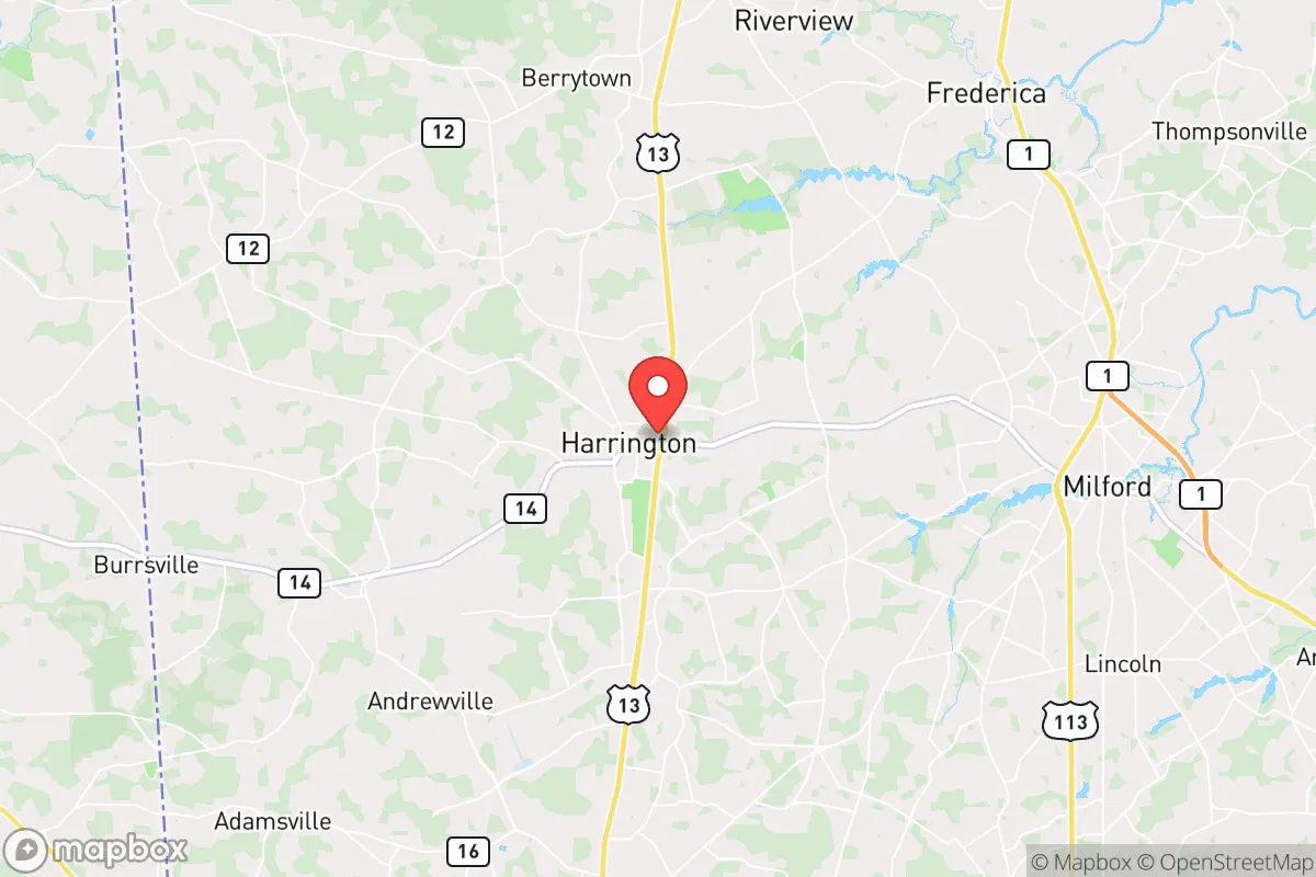
Harrington, Delaware, offers a surprisingly resilient strategic position for those prioritizing self-sufficiency and distance from major population centers, though it is not without its own vulnerabilities. Located in Kent County, roughly 40 miles south of Wilmington and 50 miles north of Salisbury, MD, this small city of roughly 3,800 people sits in a sweet spot—close enough to access regional infrastructure but far enough from the dense corridors of I-95 to avoid the worst of a cascading collapse scenario. The area’s agricultural base, low population density, and relative obscurity make it a viable option for relocators who want to be prepared for civic unrest, supply chain disruptions, or larger-scale disasters, provided they understand the specific trade-offs involved.
Geographic position and natural advantages for long-term security
Harrington’s primary strategic asset is its location within the Delmarva Peninsula, a region that functions as a natural buffer zone. Bounded by the Delaware Bay to the east and the Chesapeake Bay to the west, the peninsula limits ingress and egress to a handful of choke points—namely the Chesapeake Bay Bridge, the Delaware Memorial Bridge, and the Lewes-Cape May Ferry. In a scenario involving mass evacuation from the Northeast Corridor, these routes would become impassable within hours, but for those already living in Harrington, the same geography works as a defensive perimeter. The city sits inland, roughly 20 miles from the coast, reducing exposure to storm surge while still benefiting from the moderating influence of the Atlantic on winter temperatures. The surrounding landscape is flat, agricultural, and sparsely populated, with vast tracts of farmland that offer both privacy and potential for food production. The C&D Canal, about 25 miles north, is a strategic waterway worth noting—it connects the Delaware River to the Chesapeake Bay and could become a contested transit point in a national emergency, but Harrington is far enough south to avoid direct fallout from any disruption there.
Risks, exposures, and proximity to fallout-relevant landmarks
No strategic assessment is complete without acknowledging the liabilities. Harrington’s biggest exposure is its proximity to the Dover Air Force Base, located just 15 miles to the northeast. While the base is a major logistical hub for the U.S. military, it is also a high-value target in any conflict scenario involving state actors. A conventional or asymmetric strike on Dover AFB would generate significant secondary effects—shockwaves, debris, and potential contamination—that could reach Harrington depending on wind direction and yield. Additionally, the base’s role in mass casualty operations (e.g., the Dover Port Mortuary) means that in a pandemic or bioweapon event, the area could become a focal point for contaminated personnel and equipment. The city is also within 50 miles of the Salem and Hope Creek nuclear generating stations in New Jersey, across the Delaware Bay. While prevailing winds typically blow from the west, a release event during a northeasterly flow could deposit fallout across central Delaware. On the plus side, Harrington is far enough from the I-95 urban corridor—Wilmington, Philadelphia, Baltimore—to avoid the immediate chaos of a city collapse. The risk of civil unrest spilling into Harrington is low, but not zero; the city’s small size means that a determined group of outsiders could overwhelm local law enforcement, which consists of a handful of officers. The local hospital, Bayhealth Emergency Center in Harrington, is a small facility with limited capacity for trauma or mass casualty events, so serious medical emergencies would require a 20-minute drive to Dover or Milford.
Practical resilience for a relocator: food, water, energy, and defensibility
For the prepper-minded relocator, Harrington’s practical resilience is a mixed bag that rewards preparation. The city sits atop the Columbia Aquifer, one of the most productive groundwater sources on the East Coast. Well depth in the area typically ranges from 50 to 150 feet, and yields are excellent—most domestic wells can produce 20 to 50 gallons per minute. This means that a property with a properly maintained well and a hand-pump backup can secure a reliable off-grid water supply, a critical advantage in a grid-down scenario. The agricultural character of the region is another major plus. Kent County is one of Delaware’s top producers of corn, soybeans, and poultry, and the local Amish and Mennonite communities in nearby areas like Dover and Felton maintain traditional farming practices that could serve as a knowledge base for new residents. The Harrington Farmers Market, one of the largest in the state, operates seasonally and provides access to local produce, meats, and crafts—useful for building supply networks before a crisis. Energy resilience is more challenging. The local grid is served by Delmarva Power, and outages are common during nor’easters and thunderstorms. Solar potential is moderate—Delaware averages about 4.5 peak sun hours per day—but net metering policies are favorable, and a properly sized solar array with battery storage can cover most household needs. Natural gas is available in town, but rural properties rely on propane or heating oil, so a backup generator and a 500-gallon propane tank are wise investments. Defensibility is a function of property choice. The city itself is laid out in a traditional grid pattern with limited natural cover, making it less ideal for a standoff scenario. However, the surrounding countryside offers numerous options: farmhouses set back from the road, properties with tree lines and drainage ditches, and parcels large enough to create a perimeter. The flat terrain means that line-of-sight is long, which is both an advantage (early warning) and a disadvantage (exposure). A property with a good well, a southern-facing roof for solar, and a defensible setback from the main road is the gold standard here.
Overall, Harrington presents a viable but not perfect strategic relocation option for those with a survivalist mindset. Its strengths lie in geographic isolation, abundant groundwater, and agricultural self-sufficiency, while its weaknesses center on proximity to Dover AFB, limited medical infrastructure, and vulnerability to coastal storm surge and nuclear fallout from New Jersey. For a single individual or a family willing to invest in off-grid systems and build local connections—particularly with the farming community—Harrington offers a realistic base of operations for weathering the kind of slow-burn collapse or acute crisis that many conservatives fear. It is not a bunker, but it is a defensible, resource-rich position that rewards preparation and vigilance. The key is to treat it as a starting point, not a final answer, and to always have a secondary plan for relocation further south or west if the situation deteriorates beyond the peninsula’s capacity to sustain itself.
* Values derived from national, state, county, city and local statistics and may differ in a specific area. Last updated: 2026-04-29T20:14:57.000Z
Narrative content on this page is AI-generated and may contain mistakes. Verify any details that matter before acting on them.
ReloMaps may earn a commission from affiliate links at no extra cost to you.