
Photo: Laura Mann via Unsplash
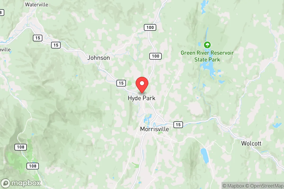
Strategic Assessment of Hyde Park, VT
Meaningful friction. Expect exposure to either population pressure, blast zones, or natural disaster risk. Consider buying a retreat property.
What does the Strategic Assessment tell us?
Our Strategic Assessment grades tactical survivability of an area. Major population centers, military targets, fallout zones, natural disasters, and border exposure all drive risk — lower exposure means a more defensible position in a crisis.
This is heavily inspired by Joel Skousen's Strategic Relocation book. Highly recommended you checkout the book ($)What does this tell us?
Our Strategic Assessment grades tactical survivability of an area. Major population centers, military targets, fallout zones, natural disasters, and border exposure all drive risk — lower exposure means a more defensible position in a crisis.
This is heavily inspired by Joel Skousen's Strategic Relocation book. Highly recommended you checkout the book ($)Strategic Pillars

Key Distances
Regional Safe Places
Below is our recommended "safe zones" in Vermont and the surrounding area based on our strategic heuristics. For most people, it's unrealistic to live in a “safe zone” full-time due to work, family or other personal reasons. They tend to be more rural. However, many of these areas are perfect for second homes and retreat properties that double as a vacation home or even a short-term rental.


Important Note: For informational purposes only. This does not mean nothing bad ever happens in the green zones. Please use common sense. This is based on public data and modeled with AI. We tried to take a conservative approach but mistakes happen. We update this regularly as new information becomes available.
Solar Generator Recommendations
Backup power matters more here than in safer locations. We've picked three solar generators across budgets and capacity tiers — start with the budget unit if you only need a few essentials, or step up if you want to run a fridge and HVAC for days at a time.

Jackery Portable Power Station Explorer 300
Budget OptionPower on the Go: Weighing only 11 lbs, it's convenient to set up and store with book-sized foldable solar panels

BLUETTI Portable Power Station AC180
Designed for both indoor and outdoor scenarios, AC180 is highly capable as it has a robost capacity and continuous output power.

EF ECOFLOW DELTA Pro Ultra Power Station
Upgraded PickEcoFlow DELTA Pro Ultra is a whole-home energy system designed to grow with your family. Integrated with the Smart Home Panel 2, it scales to meet your evolving energy needs — keeping your home powered, intelligent, and secure through every stage of life.
We earn a commission, at no additional cost to you.
Strategic Assessment Analysis
Hyde Park, Vermont, offers a compelling strategic position for those prioritizing resilience and self-sufficiency, but it is not without its trade-offs. Nestled in Lamoille County, this small town of roughly 3,000 residents sits in a valley along the Lamoille River, roughly 30 miles from the Canadian border and 45 miles from Burlington. Its location provides a meaningful buffer from the major population centers and fallout-relevant infrastructure of the Northeast, while still offering access to essential supply routes and regional medical care. For a relocator with a prepper mindset, Hyde Park represents a middle-ground option: remote enough to avoid the worst of urban collapse, yet connected enough to avoid total isolation.
Geographic position and natural advantages for long-term security
Hyde Park’s geography is its primary strategic asset. The town is surrounded by the Green Mountains, with the Worcester Range to the east and the Mount Mansfield massif to the west. These natural barriers provide a degree of physical defensibility and limit the flow of traffic from the more populated Interstate 89 corridor, which runs about 15 miles to the west. The Lamoille River, which runs through the town center, offers a reliable surface water source, though it is not a pristine wilderness stream—it carries agricultural runoff and some industrial legacy from upstream mills. The surrounding forests are dense and largely undeveloped, providing ample cover, firewood, and potential foraging grounds. The area’s elevation (roughly 700 feet) means winters are harsh—average January lows hover around 8°F—but this cold itself is a defensive asset, as it discourages transient populations and slows the spread of disease in a grid-down scenario. The town’s low population density (about 40 people per square mile in the county) means fewer eyes on your activities and less competition for local resources during a crisis.
Risks, exposures, and proximity to fallout-relevant landmarks
The most significant risk for Hyde Park is its proximity to the Burlington-South Burlington metropolitan area, which is home to roughly 220,000 people and includes the University of Vermont Medical Center, the state’s largest hospital and a likely target for civil unrest or resource-seeking refugees. Burlington is also a hub for progressive activism, which could become a flashpoint during national instability. The town sits about 45 miles from the Vermont Yankee nuclear power plant site in Vernon (decommissioned but still storing spent fuel), and roughly 80 miles from the Seabrook Station nuclear plant in New Hampshire. While these distances provide a meaningful buffer from a direct blast or plume, prevailing winds from the southwest could carry fallout into the Lamoille Valley in a worst-case scenario. More immediately concerning is the presence of the Morrisville-Stowe State Airport (about 10 miles away), which could become a FEMA or military logistics hub during a crisis, drawing unwanted attention. The Lamoille River itself is a double-edged sword: it provides water but also poses a flood risk, particularly during spring thaw or heavy rain events, as seen in the 2011 Tropical Storm Irene flooding that damaged roads and bridges in the area. The town’s reliance on a single main road (VT-15) for east-west travel is a vulnerability—a single bridge failure or landslide could cut off access to supplies or medical care.
Practical resilience for a relocator: food, water, energy, and defensibility
For a relocator serious about self-sufficiency, Hyde Park offers a mixed bag. The growing season is short (roughly 120 frost-free days), but the valley soils are fertile enough for small-scale gardening, and the local agricultural scene is active—there are several working farms within a 10-mile radius, including dairy operations and community-supported agriculture (CSA) programs. The Lamoille River and nearby Lake Elmore (about 8 miles south) provide fishing and a backup water source, but you will need robust filtration: the river carries sediment and agricultural chemicals. Groundwater is generally good, with most wells producing 5–15 gallons per minute, but new well drilling can cost $10,000–$20,000. For energy, the region is heavily wooded, making wood heat a viable primary option—most homes in the area already have wood stoves or boilers. Solar potential is moderate (roughly 4.2 peak sun hours per day), but the long, cloudy winters mean you will need a substantial battery bank or a backup generator. The town has no natural gas infrastructure; most homes rely on propane, fuel oil, or wood. Defensibility is decent but not fortress-like: the valley floor is open, but the surrounding hillsides offer good vantage points and limited approach routes. The local population is generally self-reliant and rural-minded, which means less friction with neighbors who share similar values, but also less tolerance for outsiders who do not pull their weight. The nearest major hospital is Copley Hospital in Morrisville (10 minutes away), which is a small critical-access facility—adequate for routine emergencies but not for trauma. For serious medical needs, you are looking at a 45-minute drive to UVM Medical Center in Burlington, which could be compromised during a crisis.
The overall strategic picture for Hyde Park
Hyde Park is not a bug-out location for the unprepared—it is a long-term resilience play for someone willing to invest in infrastructure and community integration. Its strengths are its remoteness, natural water access, and low population density, which provide a solid foundation for weathering short-to-medium-term disruptions. Its weaknesses are its flood risk, single-road dependency, and proximity to a major population center that could become a source of instability. For a conservative-leaning relocator concerned with civic unrest, mass casualty events, or supply chain collapse, Hyde Park offers a viable option if you are willing to harden your property, stockpile supplies, and build relationships with the local farming community. It is not a prepper paradise—the winters are brutal, the growing season is short, and the nearest major city is close enough to be a threat but far enough to be inconvenient. But for those who value quiet, self-reliance, and a community that largely keeps to itself, Hyde Park is a strategic foothold in a state that still values individual liberty. Just do not expect to go unnoticed—everyone knows everyone in a town of 3,000, and your reputation will precede you.
* Values derived from national, state, county, city and local statistics and may differ in a specific area. Last updated: 2026-05-04T02:42:45.000Z
Narrative content on this page is AI-generated and may contain mistakes. Verify any details that matter before acting on them.
ReloMaps may earn a commission from affiliate links at no extra cost to you.