Photo: Wikipedia
Strategic Assessment of Pershing County
Deep buffer from population centers and strategic targets. Low natural disaster risk and minimal exposure to border or coastal threats.
What does the Strategic Assessment tell us?
Our Strategic Assessment grades tactical survivability of an area. Major population centers, military targets, fallout zones, natural disasters, and border exposure all drive risk — lower exposure means a more defensible position in a crisis.
This is heavily inspired by Joel Skousen's Strategic Relocation book. Highly recommended you checkout the book ($)What does this tell us?
Our Strategic Assessment grades tactical survivability of an area. Major population centers, military targets, fallout zones, natural disasters, and border exposure all drive risk — lower exposure means a more defensible position in a crisis.
This is heavily inspired by Joel Skousen's Strategic Relocation book. Highly recommended you checkout the book ($)Strategic Pillars

Key Distances
Strategic Assessment Analysis
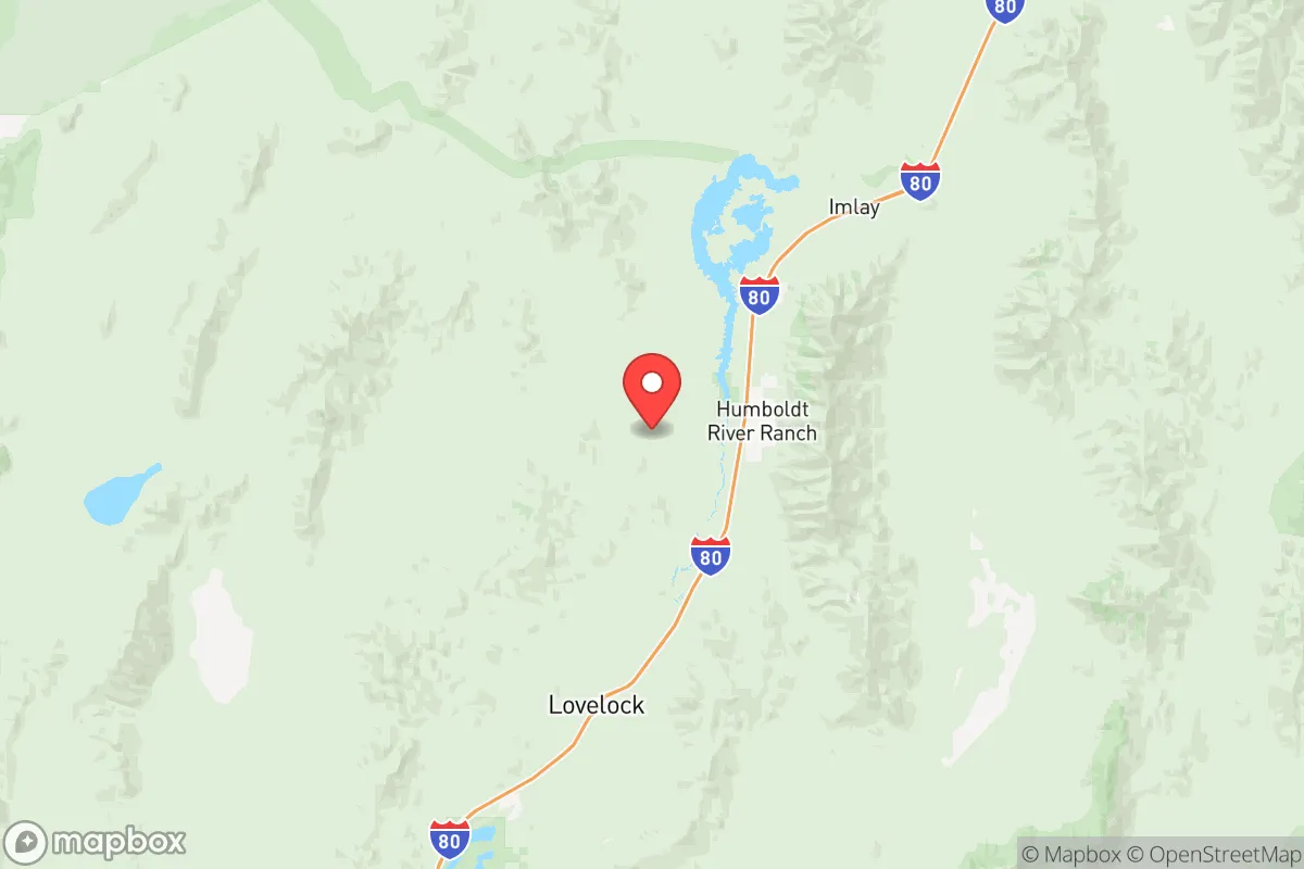
Pershing County, Nevada, offers a strategic relocation option for those prioritizing resilience and distance from major population centers, sitting roughly 90 miles northeast of Reno and 170 miles from the Salt Lake City metro area. Its low population density—around 6,500 residents spread across 6,000 square miles—means you’re not rubbing shoulders with crowds when things go sideways, and the county’s position along Interstate 80 provides a critical east-west corridor without the congestion of urban hubs. The county seat, Lovelock, serves as the practical anchor, with smaller communities like Imlay and Unionville offering even deeper seclusion. For a conservative-leaning individual or family focused on self-reliance, this area’s combination of remoteness and access to a major highway makes it a viable base for weathering civic unrest or supply chain disruptions.
Geographic position and natural advantages for long-term stability
Pershing County sits in the Great Basin, a high desert region with elevations ranging from 3,900 to over 8,000 feet, which provides natural barriers against easy access. The Humboldt River runs through the county, offering a reliable surface water source—critical for off-grid living—and the surrounding Humboldt Range and West Humboldt Range create defensible terrain with limited entry points. Lovelock itself is situated at the intersection of I-80 and US-95, giving you two major routes for evacuation or supply runs, while the nearby Rye Patch Reservoir (about 20 miles north) adds a significant water storage and recreation asset. The county’s agricultural base, including alfalfa and cattle operations, means local food production is already established, reducing reliance on distant supply chains. For a prepper mindset, the area’s isolation from major targets—no refineries, military bases, or ports within 50 miles—means fallout risks from a strategic strike are minimal, though the Hawthorne Army Depot (about 100 miles south) is a potential concern for conventional munitions storage.
Risks, exposures, and proximity to fallout-relevant landmarks
While Pershing County’s remoteness is a strength, it’s not immune to risks. The biggest exposure is the Hawthorne Army Depot, roughly 100 miles south in Mineral County, which stores conventional munitions and could be a target in a conflict scenario—though prevailing winds typically blow south, reducing fallout drift toward Pershing. Closer to home, the Interstate 80 corridor itself is a double-edged sword: it’s your lifeline for supplies, but it also funnels traffic from Reno and Salt Lake City during a crisis, potentially bringing transient populations through Lovelock. The county’s proximity to the Winnemucca area (about 30 miles east) introduces some risk from mining operations, particularly the Turquoise Ridge gold mine, which could attract economic disruption or labor unrest. Natural hazards include drought, wildfire in the surrounding ranges, and occasional flash flooding along the Humboldt River—none catastrophic, but worth planning for with stored water and firebreaks. On the positive side, there are no nuclear power plants, major chemical facilities, or large-scale refineries within 150 miles, making this one of the safer spots in the western US for avoiding industrial fallout.
Practical resilience for a relocator: food, water, energy, and defensibility
For a family or individual looking to set up a resilient homestead, Pershing County offers solid fundamentals. Water access is the top priority: the Humboldt River and Rye Patch Reservoir provide surface water, but groundwater is available at depths of 100-300 feet, and many rural properties already have wells. The county’s agricultural history means soil is workable for gardens, though the short growing season (about 120 days) requires cold-hardy crops like potatoes, carrots, and kale. Food storage is practical here—Lovelock has a small grocery co-op and a Walmart-affiliated store, but bulk supplies from Reno or Salt Lake City are a 2-3 hour drive, so stockpiling is wise. Energy independence is achievable: solar potential is excellent with over 300 sunny days per year, and wind is consistent in the passes, though grid power is available in town. Off-grid setups are common, and local regulations are minimal—no HOA restrictions in unincorporated areas. Defensibility is strong: the open terrain allows for long sightlines, and the surrounding mountains create natural chokepoints. Lovelock’s small police force (about 8 officers) and county sheriff’s office (roughly 15 deputies) mean you can’t rely on rapid law enforcement response, so community networks and personal security measures are essential. The local population is predominantly conservative, with a strong ranching culture, so you’ll find like-minded neighbors who value self-reliance and mutual aid.
The overall strategic picture for Pershing County is one of balanced isolation and practical access. It’s not a bunker—you’ll need to plan for water, food, and energy self-sufficiency—but it offers a rare combination of low risk from national-level disruptions, defensible geography, and a community that shares your values. The trade-off is distance from major medical facilities (the nearest trauma center is in Reno, 90 minutes away) and limited local employment outside mining and agriculture, but for a relocator focused on resilience over convenience, that’s a fair price. If you’re serious about being prepared for civic unrest or mass casualty events, this county deserves a hard look—just bring your own well pump and a good stock of ammunition.
* Values derived from national, state, county, city and local statistics and may differ in a specific area. Last updated: 2026-05-12T09:53:24.000Z
Narrative content on this page is AI-generated and may contain mistakes. Verify any details that matter before acting on them.
ReloMaps may earn a commission from affiliate links at no extra cost to you.