
Photo: Wikipedia
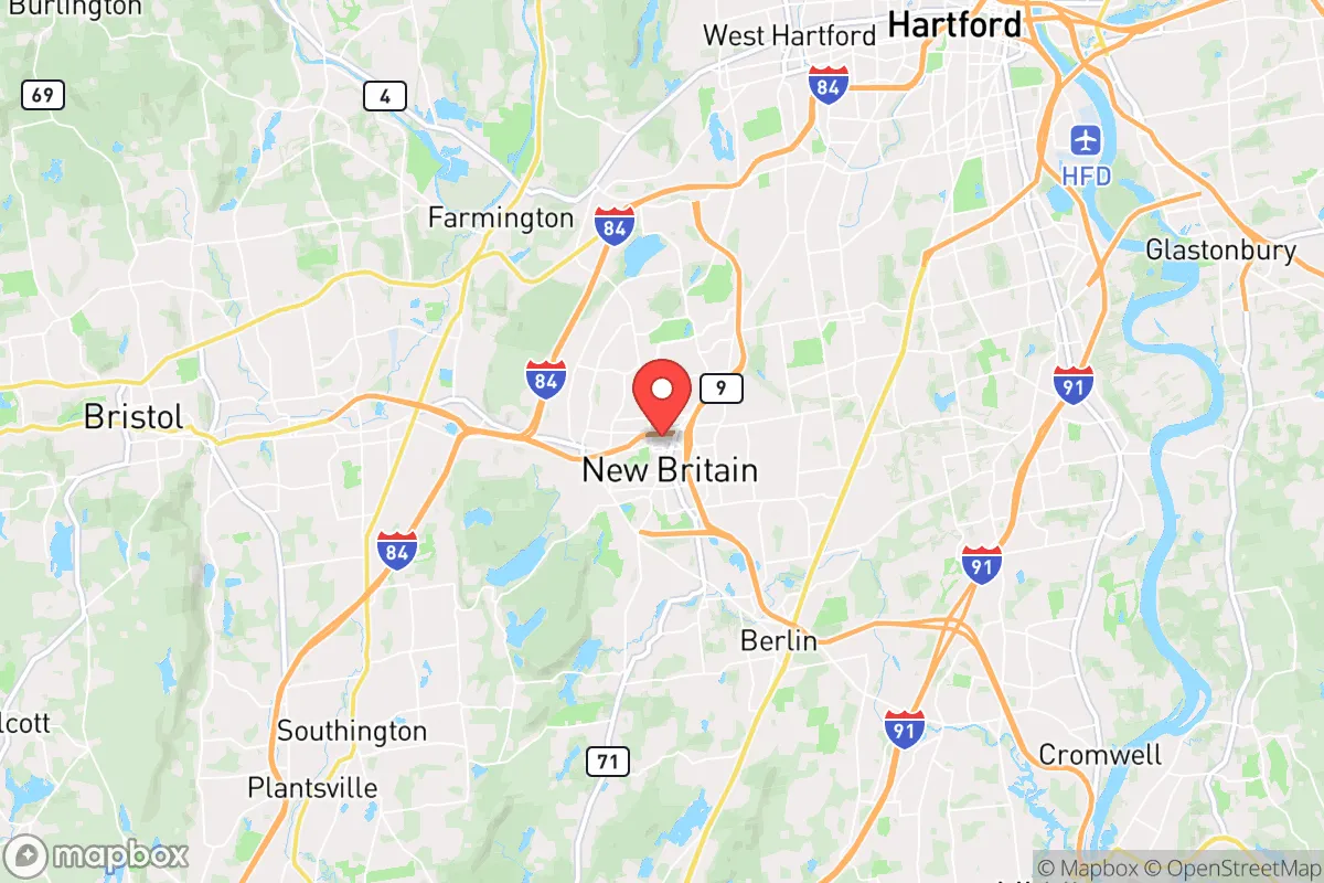
Strategic Assessment of New Britain, CT
Multiple tactical vulnerabilities. Population density, target proximity, or disaster risk are likely compounding. A retreat property and exit planning is required.
What does the Strategic Assessment tell us?
Our Strategic Assessment grades tactical survivability of an area. Major population centers, military targets, fallout zones, natural disasters, and border exposure all drive risk — lower exposure means a more defensible position in a crisis.
This is heavily inspired by Joel Skousen's Strategic Relocation book. Highly recommended you checkout the book ($)What does this tell us?
Our Strategic Assessment grades tactical survivability of an area. Major population centers, military targets, fallout zones, natural disasters, and border exposure all drive risk — lower exposure means a more defensible position in a crisis.
This is heavily inspired by Joel Skousen's Strategic Relocation book. Highly recommended you checkout the book ($)Strategic Pillars

Key Distances
Regional Safe Places
Below is our recommended "safe zones" in Connecticut and the surrounding area based on our strategic heuristics. For most people, it's unrealistic to live in a “safe zone” full-time due to work, family or other personal reasons. They tend to be more rural. However, many of these areas are perfect for second homes and retreat properties that double as a vacation home or even a short-term rental.


Important Note: For informational purposes only. This does not mean nothing bad ever happens in the green zones. Please use common sense. This is based on public data and modeled with AI. We tried to take a conservative approach but mistakes happen. We update this regularly as new information becomes available.
Solar Generator Recommendations
Backup power matters more here than in safer locations. We've picked three solar generators across budgets and capacity tiers — start with the budget unit if you only need a few essentials, or step up if you want to run a fridge and HVAC for days at a time.

Jackery Portable Power Station Explorer 300
Budget OptionPower on the Go: Weighing only 11 lbs, it's convenient to set up and store with book-sized foldable solar panels

BLUETTI Portable Power Station AC180
Designed for both indoor and outdoor scenarios, AC180 is highly capable as it has a robost capacity and continuous output power.

EF ECOFLOW DELTA Pro Ultra Power Station
Upgraded PickEcoFlow DELTA Pro Ultra is a whole-home energy system designed to grow with your family. Integrated with the Smart Home Panel 2, it scales to meet your evolving energy needs — keeping your home powered, intelligent, and secure through every stage of life.
We earn a commission, at no additional cost to you.
Strategic Assessment Analysis
New Britain, Connecticut, presents a mixed bag for the strategic relocator with a prepper mindset. Its core resilience lies in its position as a secondary urban center within a densely populated corridor, offering some industrial capacity and infrastructure, but its proximity to major metropolitan areas and critical infrastructure targets introduces significant vulnerabilities. For those prioritizing self-sufficiency and security in an era of potential civic unrest, New Britain demands a clear-eyed assessment of its geographic assets and its liabilities.
Geographic position and natural advantages for long-term survival
New Britain's location in central Connecticut offers a few genuine strategic advantages. It sits roughly 10 miles southwest of Hartford and about 100 miles from both New York City and Boston, placing it within a region that would be heavily affected by any major disruption in those hubs, but not directly in the blast zone of a primary target. The city is situated in the Connecticut River Valley, which provides relatively fertile soil and access to the Connecticut River watershed, a critical resource for long-term water security. The surrounding landscape includes the Metacomet Ridge and the Hanging Hills, which offer some natural defensibility and potential for off-grid retreats within a 20-30 minute drive. The area's temperate climate, with four distinct seasons, is manageable for those with proper preparation, though winter storms can be a recurring challenge. The presence of Central Connecticut State University provides a pool of skilled labor and potential community resources, though in a collapse scenario, a large student population could also become a liability. The city's industrial history, particularly in hardware and manufacturing, means there is a base of mechanical and engineering knowledge that could be tapped for repairs and fabrication in a post-disaster environment.
Risks, exposures, and proximity to fallout-relevant landmarks
The most significant strategic drawback of New Britain is its location within the Northeast Corridor, one of the most densely populated and economically critical regions in the United States. The city is within a 30-mile radius of Bradley International Airport, a major transportation hub that would be a high-priority target in a conflict scenario. It is also within 15 miles of the Hartford-New Haven rail corridor, a critical piece of national infrastructure. The presence of Pratt & Whitney in East Hartford, a major defense contractor and jet engine manufacturer, is a double-edged sword: it provides economic stability but also makes the region a potential target for sabotage or direct attack. The city itself is not a primary target, but the fallout and secondary effects from a strike on Hartford, New Haven, or even the New York metro area would be severe. The prevailing winds would carry fallout from a New York City event directly over Connecticut. Additionally, the Millstone Nuclear Power Station in Waterford, about 40 miles southeast, presents a risk of radiological release, whether from accident or attack. In a scenario of widespread civil unrest, New Britain's dense urban layout, with many multi-family homes and limited green space, would make it difficult to defend or to maintain a low profile. The city's population of roughly 70,000, combined with its proximity to Hartford's 120,000, means that any major disruption would trigger a rapid outflow of people, clogging the limited arterial roads like I-84 and Route 9.
Practical resilience for a relocator: food, water, energy, and defensibility
For a relocator considering New Britain, the practical challenges of self-sufficiency are substantial. The city's water supply comes from the New Britain Water Department, which draws from reservoirs in the surrounding towns of Berlin, Southington, and New Britain itself. This centralized system is vulnerable to contamination or disruption. A private well is not an option for most in-city properties, so a relocator would need to plan for rainwater catchment, filtration, and storage. The electrical grid is typical of the Northeast, with overhead lines vulnerable to ice storms and high winds. Eversource Energy is the primary provider, and outages lasting several days are not uncommon after major storms. Solar with battery backup is feasible but requires roof space and a significant upfront investment. Natural gas is available in much of the city, which is a plus for heating and cooking, but the pipeline infrastructure is a potential target. Food production is limited by the urban environment. Community gardens exist, but they are not secure. A relocator would need to rely on stockpiling, barter, or securing a secondary property in a more rural area like Litchfield County or the Quiet Corner. Defensibility is poor in the city core. The best option would be a property on the outskirts, near the Berlin or Southington town lines, where there is more space and fewer points of entry. The city's police department is professional but would be overwhelmed in a major crisis. The presence of the New Britain Fire Department and Hartford Hospital (about 10 miles away) is a positive for immediate medical emergencies, but in a long-term collapse, these resources would be depleted quickly.
The overall strategic picture for New Britain is one of calculated risk. It is not a primary target, but it sits in the shadow of several. Its industrial base and central location offer some advantages for those who can leverage them for trade and repair, but its dense urban character, reliance on centralized infrastructure, and proximity to major population centers make it a poor choice for those seeking true self-sufficiency or a low-profile retreat. For a relocator with a prepper mindset, New Britain might serve as a temporary base for building skills and resources before moving to a more defensible rural property, or as a location for a small, well-stocked urban safe house for short-term contingencies. It is not a place to ride out a long-term collapse, but it could be a viable option for those who understand its limitations and have a clear plan for evacuation or adaptation. The key is to treat New Britain as a strategic node, not a final destination, and to have your bug-out route to the north or west already mapped and practiced.
* Values derived from national, state, county, city and local statistics and may differ in a specific area. Last updated: 2026-04-19T08:09:22.000Z
Narrative content on this page is AI-generated and may contain mistakes. Verify any details that matter before acting on them.
ReloMaps may earn a commission from affiliate links at no extra cost to you.