Photo: Wikipedia
Strategic Assessment of Pendleton, OR
Workable tactical position. Some exposure to population density or targets, but generally defensible in a crisis.
What does the Strategic Assessment tell us?
Our Strategic Assessment grades tactical survivability of an area. Major population centers, military targets, fallout zones, natural disasters, and border exposure all drive risk — lower exposure means a more defensible position in a crisis.
This is heavily inspired by Joel Skousen's Strategic Relocation book. Highly recommended you checkout the book ($)What does this tell us?
Our Strategic Assessment grades tactical survivability of an area. Major population centers, military targets, fallout zones, natural disasters, and border exposure all drive risk — lower exposure means a more defensible position in a crisis.
This is heavily inspired by Joel Skousen's Strategic Relocation book. Highly recommended you checkout the book ($)Strategic Pillars

Key Distances
Regional Safe Places
Below is our recommended "safe zones" in Oregon and the surrounding area based on our strategic heuristics. For most people, it's unrealistic to live in a “safe zone” full-time due to work, family or other personal reasons. They tend to be more rural. However, many of these areas are perfect for second homes and retreat properties that double as a vacation home or even a short-term rental.


Important Note: For informational purposes only. This does not mean nothing bad ever happens in the green zones. Please use common sense. This is based on public data and modeled with AI. We tried to take a conservative approach but mistakes happen. We update this regularly as new information becomes available.
Solar Generator Recommendations
Backup power matters more here than in safer locations. We've picked three solar generators across budgets and capacity tiers — start with the budget unit if you only need a few essentials, or step up if you want to run a fridge and HVAC for days at a time.

Jackery Portable Power Station Explorer 300
Budget OptionPower on the Go: Weighing only 11 lbs, it's convenient to set up and store with book-sized foldable solar panels

BLUETTI Portable Power Station AC180
Designed for both indoor and outdoor scenarios, AC180 is highly capable as it has a robost capacity and continuous output power.

EF ECOFLOW DELTA Pro Ultra Power Station
Upgraded PickEcoFlow DELTA Pro Ultra is a whole-home energy system designed to grow with your family. Integrated with the Smart Home Panel 2, it scales to meet your evolving energy needs — keeping your home powered, intelligent, and secure through every stage of life.
We earn a commission, at no additional cost to you.
Strategic Assessment Analysis
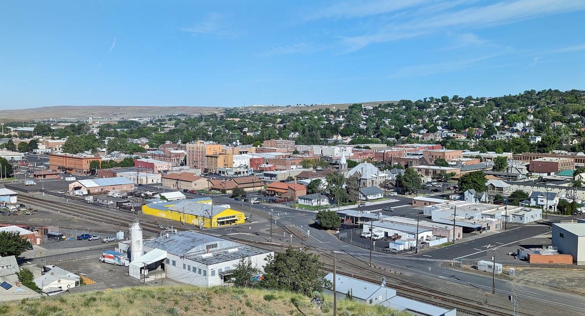
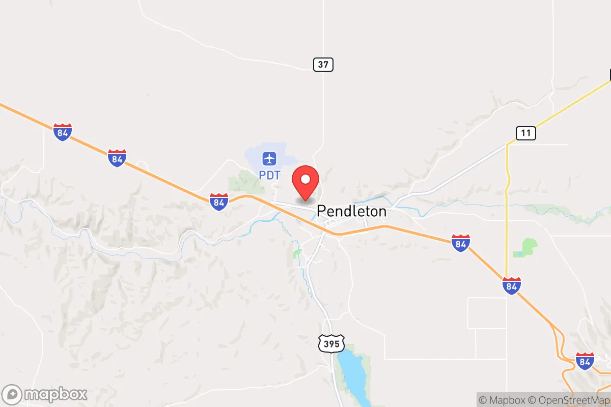
Pendleton, Oregon occupies a strategic sweet spot for those prioritizing resilience in an increasingly uncertain world. Anchored in the northeast corner of the state, it sits far from the major population centers of Portland, Seattle, and Boise—each over three hours away—while maintaining direct access to Interstate 84 and the Columbia River corridor. This positioning offers a unique blend of insulation from urban unrest and the logistical connectivity needed for supply and movement. For the prepper or survivalist looking at the big picture, Pendleton presents a location that is remote enough to buy time, yet connected enough to avoid total isolation.
Geographic position and natural advantages for long-term security
Pendleton's geography is its primary defensive asset. The city lies at the western edge of the Blue Mountains, with the Umatilla River cutting through its southern side. This puts it in a rain shadow that keeps the climate semi-arid—less than 13 inches of precipitation annually—which means fewer mold and rot issues for stored supplies, and less dependence on flood-prone valleys for agriculture. The surrounding Umatilla County is sparsely populated, with roughly 80,000 people spread over 3,200 square miles, giving you room to breathe and maneuver. The Columbia Basin provides fertile ground for dryland wheat farming and grazing, so local food production is already established. Water access is a mixed bag: the Umatilla River runs through town, but surface water rights are heavily allocated, so securing a well or a placement near a tributary is a priority. The region is also within a few hours of the Wallowa-Whitman National Forest and the Umatilla National Forest, offering vast tracts of public land for hunting, foraging, and retreat if things go sideways.
Risks, exposures, and proximity to fallout-relevant landmarks
No location is a fortress, and Pendleton has its exposures. The biggest strategic concern is the Umatilla Chemical Depot, located about 10 miles south of the city near Hermiston. Although the chemical weapons stockpile was destroyed in the 2010s, the site remains a federal facility with potential residual hazards and still operates as a training and logistics hub. In a scenario involving targeted strikes or sabotage, that depot is a liability. Additionally, Pendleton sits within 75 miles of the Hanford Site—the decommissioned nuclear production facility with massive underground contamination. A catastrophic event at Hanford—whether from earthquake, terror, or decay—would send a plume up the Columbia River corridor, potentially affecting Pendleton depending on wind patterns. The city also lies near the active Mount Hood volcanic zone, but that threat is more distant. On the plus side, Pendleton is far from any major military nuclear targets like ICBM silos in Montana or major command centers. The risk profile is moderate: you are not in the blast radius of a major city, but you are within a day's drive of infrastructure that could become a secondary target.
Practical resilience for a relocator: food, water, energy, and defensibility
For a relocator thinking about daily survival, Pendleton offers real advantages and real homework. Food: The region is a breadbasket of Oregon, with extensive wheat, hay, and livestock operations. The Pendleton Farmers Market runs seasonally, but more importantly, buying bulk grain or bartering with local ranchers is feasible if you build relationships early. The area has a strong agricultural economy, meaning food storage is less abstract here than in most suburban settings. Water: Municipal water comes from the Umatilla River, which is vulnerable to contamination upstream (thinking of the depot or Hanford runoff). A drilled well on private land—typically 200-400 feet deep—is the gold standard here, and many rural properties already have one. Rainwater catchment is possible but limited due to low precipitation. Energy: The grid is served by the Bonneville Power Administration, which draws heavily from hydroelectric dams on the Columbia and Snake Rivers. This is a double-edged sword: those dams are critical infrastructure and potential targets. Solar is viable—the area gets around 200 sunny days a year—but winter inversions in the valley can reduce output. A backup generator with a buried propane tank is almost mandatory. Defensibility: Pendleton's layout helps. The city is compact, with the river providing a natural barrier on the south side. The surrounding terrain is rolling hills and rimrock, offering good vantage points for any defensible perimeter you set up. Rural properties south and east of town sit on elevated benches with long sightlines. The Pendleton airport is a small general aviation field, which could be a plus if you need air evacuation or supply drops. Just be aware that the local population is armed—this is eastern Oregon, where gun ownership is the norm—which means the social environment is not hostile to self-reliance, but it does mean you are not the only one prepared.
Overall strategic picture for a survival-minded relocator
Pendleton is a solid B+ on the prepper scorecard. It trades the high risk of West Coast metropolitan collapse for a manageable exposure to specific industrial targets. The isolation is genuine—Portland is 3.5 hours west, Spokane 2.5 hours north, Boise 3.5 hours east—so you are not going to be overrun by fleeing urbanites in the first 48 hours of a crisis. The local community is conservative, rural, and accustomed to hardship: the Pendleton Woolen Mills and the local ranching culture mean people know how to work with their hands and keep things running. The Pacific Northwest's weak link is its heavy reliance on the Columbia River Gorge for transportation and power transmission; a single coordinated attack on the dams could cripple the region's grid and logistics. Pendleton sits close enough to that choke point to feel the pinch, but far enough to avoid the immediate chaos. If you want a base that is off the beaten path, has a defensible rural interface, and is within striking distance of multiple bioregions, Pendleton is worth a hard look. Just do not ignore the depot to the south or the Hanford ghost to the west—plan around them, and you will be in a position to weather what comes.
* Values derived from national, state, county, city and local statistics and may differ in a specific area. Last updated: 2026-05-30T09:23:09.000Z
Narrative content on this page is AI-generated and may contain mistakes. Verify any details that matter before acting on them.
ReloMaps may earn a commission from affiliate links at no extra cost to you.