Photo: Wikipedia
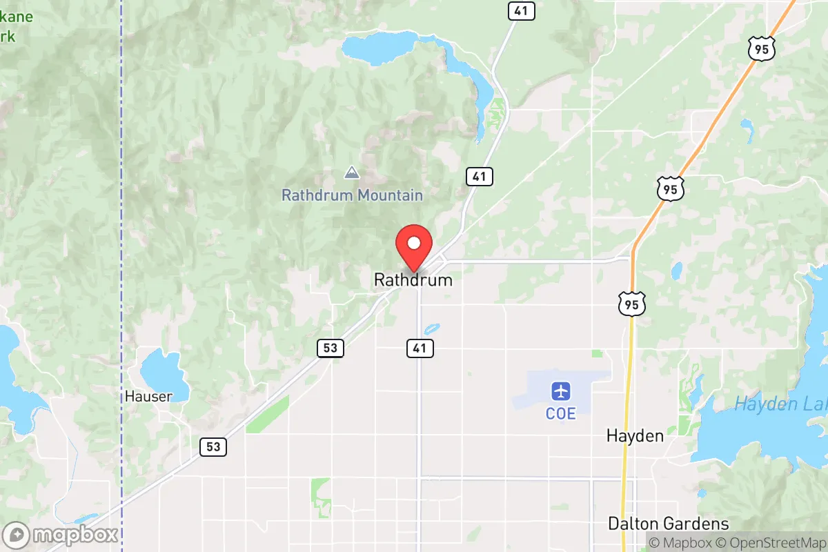
Strategic Assessment of Rathdrum, ID
Workable tactical position. Some exposure to population density or targets, but generally defensible in a crisis.
What does the Strategic Assessment tell us?
Our Strategic Assessment grades tactical survivability of an area. Major population centers, military targets, fallout zones, natural disasters, and border exposure all drive risk — lower exposure means a more defensible position in a crisis.
This is heavily inspired by Joel Skousen's Strategic Relocation book. Highly recommended you checkout the book ($)What does this tell us?
Our Strategic Assessment grades tactical survivability of an area. Major population centers, military targets, fallout zones, natural disasters, and border exposure all drive risk — lower exposure means a more defensible position in a crisis.
This is heavily inspired by Joel Skousen's Strategic Relocation book. Highly recommended you checkout the book ($)Strategic Pillars

Key Distances
Regional Safe Places
Below is our recommended "safe zones" in Idaho and the surrounding area based on our strategic heuristics. For most people, it's unrealistic to live in a “safe zone” full-time due to work, family or other personal reasons. They tend to be more rural. However, many of these areas are perfect for second homes and retreat properties that double as a vacation home or even a short-term rental.


Important Note: For informational purposes only. This does not mean nothing bad ever happens in the green zones. Please use common sense. This is based on public data and modeled with AI. We tried to take a conservative approach but mistakes happen. We update this regularly as new information becomes available.
Solar Generator Recommendations
Backup power matters more here than in safer locations. We've picked three solar generators across budgets and capacity tiers — start with the budget unit if you only need a few essentials, or step up if you want to run a fridge and HVAC for days at a time.

Jackery Portable Power Station Explorer 300
Budget OptionPower on the Go: Weighing only 11 lbs, it's convenient to set up and store with book-sized foldable solar panels

BLUETTI Portable Power Station AC180
Designed for both indoor and outdoor scenarios, AC180 is highly capable as it has a robost capacity and continuous output power.

EF ECOFLOW DELTA Pro Ultra Power Station
Upgraded PickEcoFlow DELTA Pro Ultra is a whole-home energy system designed to grow with your family. Integrated with the Smart Home Panel 2, it scales to meet your evolving energy needs — keeping your home powered, intelligent, and secure through every stage of life.
We earn a commission, at no additional cost to you.
Strategic Assessment Analysis
Rathdrum, Idaho, sits in a strategic pocket of the northern Idaho panhandle that offers a compelling mix of remoteness and accessibility for those prioritizing long-term resilience. Its location roughly 30 miles from Spokane, Washington, and 15 miles from Coeur d'Alene provides a buffer from major urban centers while still allowing for supply runs and medical access. The town’s position along the Rathdrum Prairie, with the Selkirk Mountains to the north and the Spokane River nearby, creates a natural defensive geography that limits approach vectors and offers multiple escape routes into the surrounding national forests. For a relocator concerned with civic unrest, mass casualty events, or large-scale disasters, Rathdrum’s low population density—around 10,000 residents as of 2025—and its distance from major interstate corridors reduce the risk of being caught in a mass evacuation or supply chain collapse.
Geographic position and natural advantages for long-term security
Rathdrum sits at the southern edge of the Idaho Panhandle National Forests, a vast 2.5-million-acre expanse that provides a natural buffer and a potential retreat zone. The town is situated on the Rathdrum Prairie, a high-elevation plateau at roughly 2,200 feet, which offers good drainage and avoids the floodplain risks of lower-lying areas along the Spokane River. The nearby Selkirk and Cabinet Mountains create a rain shadow effect that moderates precipitation, keeping the area drier than the coastal Pacific Northwest—a key advantage for maintaining road access and avoiding landslide risks during severe weather events. The region’s aquifer, the Spokane Valley-Rathdrum Prairie Aquifer, is one of the largest and cleanest in the country, providing a reliable groundwater source that is less vulnerable to surface contamination than many municipal systems. For a prepper, this means the ability to drill a private well with high confidence in water quality, reducing dependency on municipal infrastructure that could fail during a grid-down scenario.
Risks, exposures, and proximity to fallout-relevant landmarks
No location is without vulnerabilities, and Rathdrum has several that a strategic relocator must weigh. The most immediate risk is its proximity to Fairchild Air Force Base, located about 40 miles southwest near Spokane. Fairchild is a key refueling and airlift hub for the U.S. military, housing KC-135 Stratotankers and serving as a staging area for Pacific theater operations. In a major conflict scenario, this base becomes a high-value target for both conventional and asymmetric attacks, and fallout patterns from a strike could drift northeast toward Rathdrum depending on prevailing winds. Additionally, the town lies within 50 miles of the Spokane Rail Yard, a major freight hub that could be a target for sabotage or disruption during civil unrest. The nearby Interstate 90 corridor, which runs through Coeur d'Alene, is a primary east-west route that could become clogged with refugees or military convoys during a crisis, potentially cutting off access to Spokane’s medical facilities. On the natural disaster front, the region is in a moderate seismic zone—the 2020 Stanley earthquake (magnitude 6.5) was felt in Rathdrum—and while major quakes are rare, the area’s glacial till soils can amplify shaking. Wildfire risk is moderate but increasing; the 2021 Sundance Fire burned within 20 miles of town, and dry summers create a seasonal threat that requires defensible space planning.
Practical resilience for a relocator: food, water, energy, and defensibility
For a single individual or family looking to build a self-sufficient homestead, Rathdrum offers a workable baseline. The growing season is short—roughly 100 to 120 frost-free days—but the volcanic loam soils of the Rathdrum Prairie are fertile enough for cold-hardy crops like potatoes, carrots, kale, and apples. Local farmers’ markets and the nearby Kootenai County Fairgrounds provide access to livestock and seed stock for those starting from scratch. Water is the standout advantage: the Rathdrum Prairie Aquifer is so prolific that many residential wells produce 20 to 50 gallons per minute at depths of only 100 to 200 feet, making it feasible to run a household and small-scale irrigation without municipal hookup. Energy resilience is more challenging. The area is served by Avista Utilities, which relies on a mix of hydroelectric and natural gas, but grid reliability is average—winter ice storms can cause multi-day outages. Solar potential is decent, with about 4.5 peak sun hours per day, but snow cover in winter reduces output, so a backup generator or battery bank is essential. Wood heating is practical given the surrounding forests, but air quality regulations in Kootenai County restrict outdoor burning during inversions. Defensibility is mixed. Rathdrum’s layout is spread out, with many properties on acreage that provide standoff distance, but the town’s growth has been rapid—population increased by over 30% between 2010 and 2020—leading to more suburban-style subdivisions that reduce privacy and increase neighbor density. For a relocator, the sweet spot is a parcel of 5 to 20 acres on the northern or eastern edges of town, where the terrain rises into the foothills and offers better line-of-sight and fewer approach routes. The local sheriff’s office is responsive but understaffed, with about 1.5 deputies per 1,000 residents, so a well-stocked armory and a neighborhood watch network are practical investments.
Overall, Rathdrum presents a balanced strategic picture for the conservative prepper. It’s not a bug-out location in the wilderness sense—it’s too close to Spokane and Coeur d’Alene for that—but it functions well as a semi-rural staging area with good water, decent soil, and multiple escape routes into the national forests. The key trade-off is proximity to Fairchild AFB and the I-90 corridor, which introduce a non-zero risk of being caught in a military or civil disruption. For a relocator who values community ties, local governance that leans conservative (Kootenai County voted +18 R in 2024), and a climate that avoids the extremes of the desert or the deep north, Rathdrum is a solid choice. The prudent move is to secure a property with a well, a wood stove, and a defensible perimeter, then build relationships with the local prepper network—there are several active groups in the area—before the next crisis hits. It’s not a fortress, but it’s a defensible position with the resources to ride out a rough patch.
* Values derived from national, state, county, city and local statistics and may differ in a specific area. Last updated: 2026-05-03T04:52:33.000Z
Narrative content on this page is AI-generated and may contain mistakes. Verify any details that matter before acting on them.
ReloMaps may earn a commission from affiliate links at no extra cost to you.