Photo: Ian Hutchinson via Unsplash
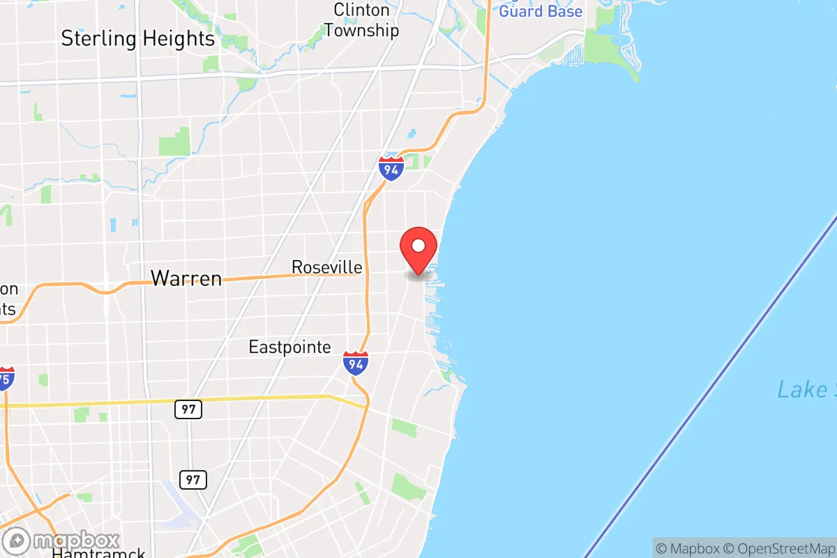
Strategic Assessment of St Clair Shores, MI
Multiple tactical vulnerabilities. Population density, target proximity, or disaster risk are likely compounding. A retreat property and exit planning is required.
What does the Strategic Assessment tell us?
Our Strategic Assessment grades tactical survivability of an area. Major population centers, military targets, fallout zones, natural disasters, and border exposure all drive risk — lower exposure means a more defensible position in a crisis.
This is heavily inspired by Joel Skousen's Strategic Relocation book. Highly recommended you checkout the book ($)What does this tell us?
Our Strategic Assessment grades tactical survivability of an area. Major population centers, military targets, fallout zones, natural disasters, and border exposure all drive risk — lower exposure means a more defensible position in a crisis.
This is heavily inspired by Joel Skousen's Strategic Relocation book. Highly recommended you checkout the book ($)Strategic Pillars

Key Distances
Regional Safe Places
Below is our recommended "safe zones" in Michigan and the surrounding area based on our strategic heuristics. For most people, it's unrealistic to live in a “safe zone” full-time due to work, family or other personal reasons. They tend to be more rural. However, many of these areas are perfect for second homes and retreat properties that double as a vacation home or even a short-term rental.


Important Note: For informational purposes only. This does not mean nothing bad ever happens in the green zones. Please use common sense. This is based on public data and modeled with AI. We tried to take a conservative approach but mistakes happen. We update this regularly as new information becomes available.
Solar Generator Recommendations
Backup power matters more here than in safer locations. We've picked three solar generators across budgets and capacity tiers — start with the budget unit if you only need a few essentials, or step up if you want to run a fridge and HVAC for days at a time.

Jackery Portable Power Station Explorer 300
Budget OptionPower on the Go: Weighing only 11 lbs, it's convenient to set up and store with book-sized foldable solar panels

BLUETTI Portable Power Station AC180
Designed for both indoor and outdoor scenarios, AC180 is highly capable as it has a robost capacity and continuous output power.

EF ECOFLOW DELTA Pro Ultra Power Station
Upgraded PickEcoFlow DELTA Pro Ultra is a whole-home energy system designed to grow with your family. Integrated with the Smart Home Panel 2, it scales to meet your evolving energy needs — keeping your home powered, intelligent, and secure through every stage of life.
We earn a commission, at no additional cost to you.
Strategic Assessment Analysis
St. Clair Shores sits in a precarious strategic position: close enough to Detroit to be within the blast radius of a major attack on the city, yet far enough to offer a buffer zone that many suburban preppers overlook. The city’s location on Lake St. Clair provides a natural water source and a potential escape route via the Great Lakes, but its dense suburban layout and proximity to I-94 and I-696 make it a chokepoint for evacuation during a crisis. For a conservative-leaning relocator weighing resilience against convenience, this area demands a hard look at trade-offs—especially when the state of the country feels increasingly unstable.
Geographic position and natural advantages for long-term survival
St. Clair Shores is a lakeside community of about 58,000 people, nestled along the western shore of Lake St. Clair, roughly 15 miles northeast of downtown Detroit. The lake itself is a massive freshwater resource—over 430 square miles—offering a reliable water supply for drinking, irrigation, and sanitation if municipal systems fail. The city’s network of canals and marinas (over 100 miles of navigable waterways) provides both a defensive barrier and a means of discreet travel by boat, which could be critical if roadways become impassable or contested. The area’s flat terrain and clay-heavy soil are less ideal for agriculture than the loam found further west in Michigan, but the proximity to Lake St. Clair means fishing and waterfowl hunting are viable protein sources. The region’s four-season climate also offers natural preservation: winter freezes can slow spoilage of stored food, while summer heat is rarely extreme enough to ruin supplies without refrigeration. However, the lack of significant elevation or forest cover means you’re exposed—both to weather and to observation—making a low-profile retreat difficult.
Risks, exposures, and proximity to fallout-relevant landmarks
The biggest strategic liability is St. Clair Shores’ proximity to Detroit, a major population center with a history of civil unrest and a high crime rate. In a mass casualty event—whether from terrorism, economic collapse, or a pandemic—Detroit’s 630,000 residents would likely flee outward, and St. Clair Shores sits directly in the path of the most logical escape routes: I-94, I-696, and M-97. The city is also within 20 miles of the Detroit Metropolitan Airport (DTW), a potential target for a coordinated attack, and within 30 miles of the Fermi 2 nuclear power plant in Monroe County. While Fermi 2 is a pressurized water reactor with containment structures, a worst-case release could send fallout northeast toward St. Clair Shores depending on wind patterns. Additionally, the city is ringed by industrial infrastructure: the St. Clair River corridor hosts multiple chemical plants and oil refineries, including the Marathon Petroleum refinery in Detroit (about 12 miles southwest). A major industrial accident or sabotage could release toxic clouds or ignite fires that overwhelm local emergency services. The dense suburban layout—mostly single-family homes on small lots with narrow streets—means that a gridlocked evacuation would be a nightmare, and the lack of rural buffer zones leaves little room for dispersion.
Practical resilience for a relocator: food, water, energy, and defensibility
For a relocator serious about self-sufficiency, St. Clair Shores offers a mixed bag. Water is the strongest asset: Lake St. Clair is a virtually unlimited source, but you’ll need a filtration system (e.g., a Berkey or a Sawyer filter) to handle potential contamination from sewage overflows or industrial runoff. The city’s municipal water comes from the Detroit Water and Sewerage Department, which has a history of infrastructure failures and billing disputes—so a backup well or rainwater catchment is advisable, though well-drilling is limited by the clay soil. Food production is challenging: most lots are 50 to 70 feet wide, leaving little room for gardens, and the soil is often compacted from decades of suburban development. Community gardens exist but are small; you’d need to rely on nearby rural areas (e.g., Macomb County’s farmlands, 20 minutes north) for bulk supplies. Energy resilience is moderate: the grid is reliable day-to-day, but DTE Energy has faced criticism for slow storm restoration and vulnerability to cyberattacks. Solar panels are feasible—the area gets about 170 sunny days per year—but homeowners’ associations (HOAs) in many neighborhoods restrict visible installations. A backup generator running on propane or natural gas is a more practical bet, and the city’s natural gas infrastructure is widespread. Defensibility is the weak point: the flat, open layout and grid-like street pattern make it easy for outsiders to navigate and hard for residents to control access. The canals offer some natural barriers, but they also create blind spots. The local police department (about 80 sworn officers) is well-funded for a city this size, but in a widespread collapse, they’d be overwhelmed. Your best bet is a tight-knit neighborhood watch and a home hardened with reinforced doors, window film, and a safe room—but don’t expect to hold off a determined group for long.
The overall strategic picture for St. Clair Shores is one of calculated risk. It’s not a remote survivalist haven—you’re still within an hour of Detroit’s chaos, and the suburban density means you can’t disappear. But for a relocator who wants to stay connected to the Great Lakes region for family or work reasons, it offers a baseline of resilience: abundant water, moderate energy options, and a community that, while not prepper-friendly in the public sense, has a strong blue-collar ethos and a history of pulling together during crises (e.g., the 2014 water crisis in Flint, which saw St. Clair Shores residents donating supplies). The key is to treat it as a staging ground, not a final retreat. Stockpile supplies for 90 days, maintain a boat for lake escape routes, and have a bug-out plan for northern Michigan (e.g., the Upper Peninsula or the Huron National Forest). If you’re willing to trade absolute security for proximity to resources and a familiar suburban lifestyle, St. Clair Shores can work—but only if you’re prepared to leave when the sirens start.
* Values derived from national, state, county, city and local statistics and may differ in a specific area. Last updated: 2026-04-24T07:43:40.000Z
Narrative content on this page is AI-generated and may contain mistakes. Verify any details that matter before acting on them.
ReloMaps may earn a commission from affiliate links at no extra cost to you.