Photo: Wikipedia
Strategic Assessment of Jefferson County
Multiple tactical vulnerabilities. Population density, target proximity, or disaster risk are likely compounding. A retreat property and exit planning is required.
What does the Strategic Assessment tell us?
Our Strategic Assessment grades tactical survivability of an area. Major population centers, military targets, fallout zones, natural disasters, and border exposure all drive risk — lower exposure means a more defensible position in a crisis.
This is heavily inspired by Joel Skousen's Strategic Relocation book. Highly recommended you checkout the book ($)What does this tell us?
Our Strategic Assessment grades tactical survivability of an area. Major population centers, military targets, fallout zones, natural disasters, and border exposure all drive risk — lower exposure means a more defensible position in a crisis.
This is heavily inspired by Joel Skousen's Strategic Relocation book. Highly recommended you checkout the book ($)Strategic Pillars

Key Distances
Strategic Assessment Analysis
Jefferson County, Texas, offers a mixed bag for the strategic relocator looking for a resilient position in an increasingly uncertain world. Its location on the Gulf Coast provides both significant economic advantages and serious exposure risks, making it a location that demands careful, sober assessment rather than blind optimism. For those willing to navigate its industrial realities and natural hazards, the area presents a unique combination of logistical utility and defensive potential, but it is far from a simple "bug out" destination.
Geographic position and natural advantages for long-term survival
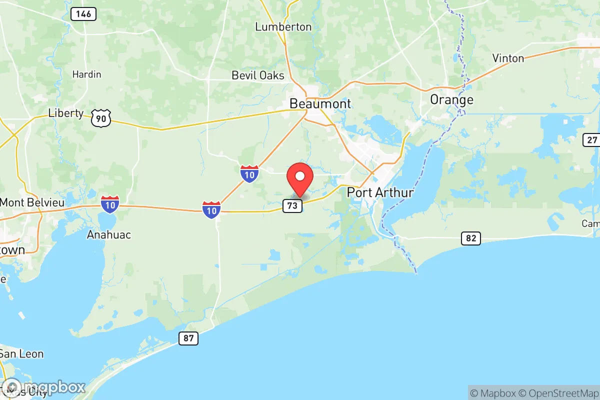
Jefferson County sits at the nexus of several critical transportation corridors, which is a double-edged sword. The county is anchored by the city of Beaumont, which lies at the intersection of Interstate 10 and US Highway 69/96/287. This gives residents direct access to Houston (90 miles west), the Louisiana border (20 miles east), and the Piney Woods region to the north. For a prepper, this means multiple egress routes if you need to move supplies or relocate, but it also means the area is a natural funnel for any mass evacuation from the Houston metroplex. The county's geography is dominated by the Neches River and Sabine River systems, which empty into Sabine Lake and the Gulf of Mexico. This provides abundant freshwater resources, though much of it is brackish near the coast. The Big Thicket National Preserve to the north offers a vast, relatively undeveloped wilderness area for hunting, foraging, and potential off-grid retreats. The terrain is flat and heavily forested with pine and hardwood, offering decent cover but poor defensible high ground. The soil is sandy loam in many areas, which is workable for small-scale agriculture if you can manage the drainage. The climate is humid subtropical, with a long growing season (roughly 250 days) that allows for year-round food production, though the heat and humidity are brutal from June through September.
Risks, exposures, and proximity to fallout-relevant landmarks
This is where Jefferson County becomes a high-risk proposition for the survivalist. The county is home to the Port of Beaumont, one of the busiest military cargo ports in the United States, and the Port Arthur petrochemical complex, which includes refineries operated by Motiva, TotalEnergies, and Valero. In a scenario involving civil unrest, mass casualty events, or geopolitical conflict, these are prime targets for disruption, sabotage, or direct attack. The Beaumont Refinery alone processes over 200,000 barrels of crude oil per day. A major incident at any of these facilities could render large portions of the county uninhabitable due to toxic chemical releases, fires, or explosions. Furthermore, the county is directly in the path of hurricane storm surge from the Gulf. The Sabine Pass area and the low-lying communities of Port Arthur, Groves, and Nederland are particularly vulnerable to flooding. Hurricane Harvey (2017) demonstrated that even inland areas like Beaumont can experience catastrophic flooding, with the Neches River cresting at record levels. For the prepper, the proximity to Houston's refinery corridor (extending from Texas City to Baytown) means that any large-scale event in that region could send refugees, contaminants, or military traffic through Jefferson County. The presence of the US Army's 842nd Transportation Battalion at the Port of Beaumont also makes the area a potential staging ground for federal response operations, which could be a positive or negative depending on your view of government intervention during a crisis.
Practical resilience for a relocator: food, water, energy, and defensibility
On the practical side, Jefferson County offers some genuine advantages for the prepared individual. Water is abundant from the Neches and Sabine rivers, as well as numerous bayous and lakes like Lake Sam Rayburn (just north in Jasper County). However, surface water in this region is heavily contaminated with industrial runoff, agricultural chemicals, and naturally occurring tannins. Any serious water collection plan requires robust filtration (reverse osmosis or distillation) and testing. Food production is viable but challenging. The soil is acidic and sandy, requiring amendment for most vegetables. Deer, feral hogs, and waterfowl are plentiful in the Big Thicket and surrounding bottomlands, providing a reliable protein source. The long growing season allows for multiple crop cycles, but the humidity promotes fungal diseases and pests. Energy independence is feasible due to the region's abundant sunlight (though often clouded by Gulf moisture) and the potential for small-scale hydro or wind in the river corridors. The local electrical grid is notoriously fragile during storms, so solar with battery backup is a wise investment. Defensibility is the weak point. The flat terrain offers little natural cover for a perimeter. The best defensive positions are in the northern part of the county, near the Big Thicket or along the Neches River bluffs (which rise 20-30 feet in places). Rural properties near China or Hamshire offer more seclusion than the dense suburban sprawl of Beaumont and Port Arthur. The county's population density is moderate (roughly 250,000 people), but the urban core is dense enough that any collapse scenario would see significant movement of people seeking food and water. The presence of multiple interstate highways and rail lines means the area is a natural corridor for both trade and trouble.
The overall strategic picture for Jefferson County is one of calculated risk. It is not a place for the casual prepper looking for a quiet, low-profile retreat. The industrial targets, hurricane exposure, and flat terrain make it a high-maintenance location that demands constant vigilance and significant investment in hardening, water purification, and evacuation planning. However, for the relocator with a specific skill set—perhaps in maritime operations, industrial logistics, or medical response—the county offers a unique niche. The economic base is strong enough to support a dual-income lifestyle while you build your resilience infrastructure. The proximity to the Gulf and the Louisiana swamps provides a potential escape route by water if land routes become compromised. Ultimately, Jefferson County is a location for the strategic thinker who understands that resilience is not about hiding, but about positioning yourself where you can leverage resources while mitigating threats. If you can manage the industrial fallout risk and the weather, the land itself can sustain you. If you cannot, the county will eat you alive. Choose accordingly.
* Values derived from national, state, county, city and local statistics and may differ in a specific area. Last updated: 2026-06-06T16:30:44.000Z
Narrative content on this page is AI-generated and may contain mistakes. Verify any details that matter before acting on them.
ReloMaps may earn a commission from affiliate links at no extra cost to you.