Photo: Wikipedia
Strategic Assessment of Washakie County
Deep buffer from population centers and strategic targets. Low natural disaster risk and minimal exposure to border or coastal threats.
What does the Strategic Assessment tell us?
Our Strategic Assessment grades tactical survivability of an area. Major population centers, military targets, fallout zones, natural disasters, and border exposure all drive risk — lower exposure means a more defensible position in a crisis.
This is heavily inspired by Joel Skousen's Strategic Relocation book. Highly recommended you checkout the book ($)What does this tell us?
Our Strategic Assessment grades tactical survivability of an area. Major population centers, military targets, fallout zones, natural disasters, and border exposure all drive risk — lower exposure means a more defensible position in a crisis.
This is heavily inspired by Joel Skousen's Strategic Relocation book. Highly recommended you checkout the book ($)Strategic Pillars

Key Distances
Strategic Assessment Analysis
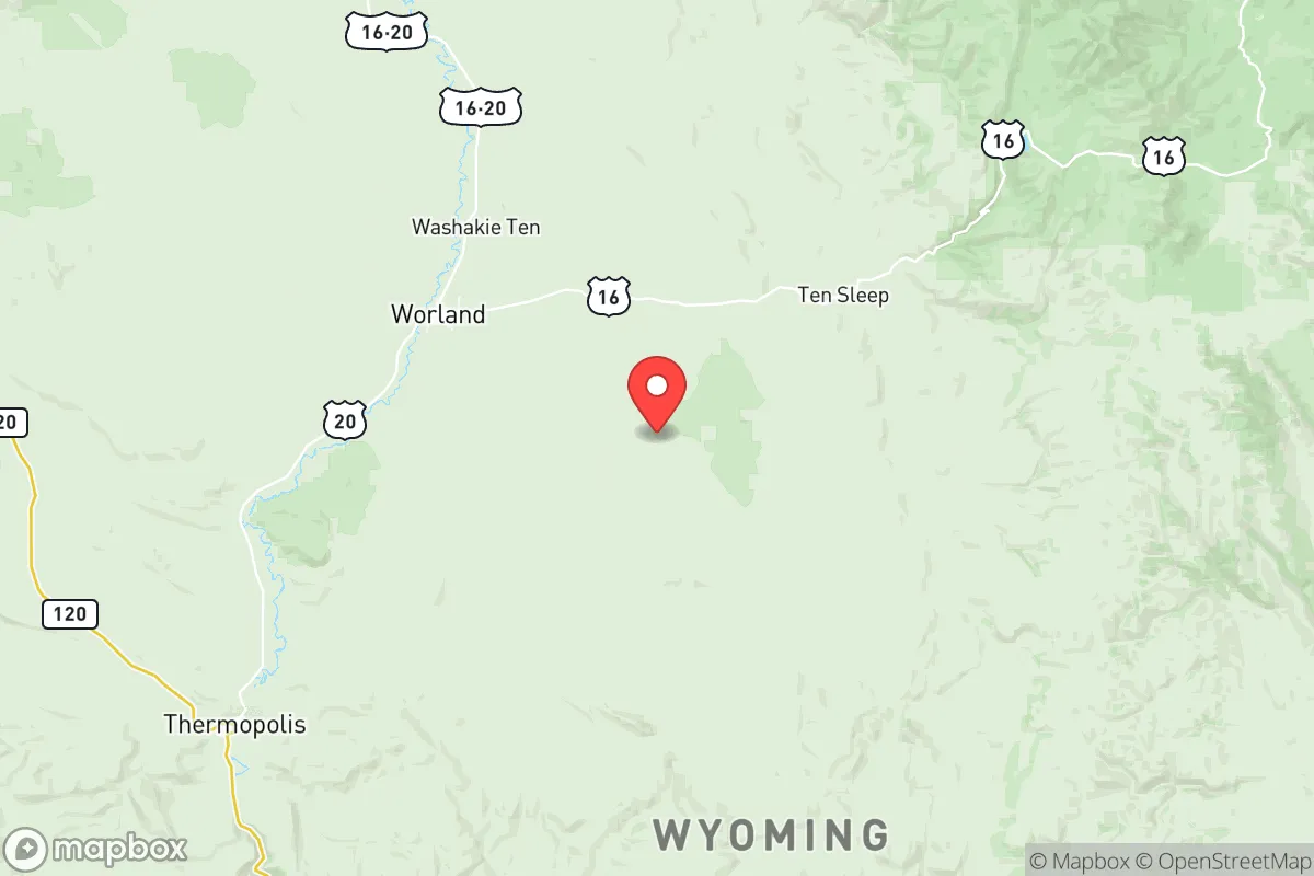
Washakie County, Wyoming, anchored by the county seat of Worland, offers a strategic combination of geographic isolation and resource abundance that makes it a serious candidate for relocation-minded individuals prioritizing long-term resilience. With a population density of roughly 2.5 people per square mile and no major interstate highways slicing through it, this region in the Bighorn Basin provides natural buffering from the cascading effects of urban unrest or infrastructure collapse. For someone looking at the national picture and wanting to be out of easy reach of both crowds and supply chain choke points, Washakie County presents a compelling, though not risk-free, option.
Why Washakie County’s location in the Bighorn Basin matters for strategic relocation
Washakie County sits in the heart of the Bighorn Basin, a large, high-desert valley ringed by the Bighorn Mountains to the east and the Absaroka Range to the west. This basin acts as a natural funnel and buffer — the passes into it are limited and easily observed, which means traffic into the area is naturally constrained. Worland, the only town of significant size, sits along the Bighorn River, a perennial water source fed by mountain snowmelt. The smaller communities — Ten Sleep, Manderson, and Kirby — offer even deeper isolation without being completely cut off from supplies. The distance to any major urban center is substantial: Casper is roughly 120 miles south, and Billings, Montana, is about 100 miles north. That mileage translates to time and friction for anyone traveling to or from the area, which is an asset in a scenario where urban evacuation routes are clogged or dangerous. The geographic position also means the county is far removed from the nation's primary industrial corridors, missile fields, and port cities — no major refineries, no intermodal rail hubs, no nuclear power plants within a hundred miles.
What are the real risks and fallout exposures in Washakie County
From a fallout and targeting perspective, Washakie County is about as clean as it gets in the lower 48. There are no Tier 1 strategic targets — no ICBM silos, no nuclear power plants, no major military installations — within the county or in adjacent areas. The nearest significant industrial infrastructure is the oil and gas processing around Riverton and Cody, but those are not primary strategic targets. The real risks here are environmental and logistical rather than geopolitical. The Bighorn Basin experiences extreme winter weather, with blizzards that can close the two primary highways — US-16 and US-20 — for days at a time. Wildfire risk in the surrounding national forest land, particularly the Bighorn National Forest to the east, is real and growing. Medical infrastructure is thin: the Washakie Medical Center in Worland is a critical access hospital, but for trauma or specialized care, a medevac flight to Billings or Casper is the reality. The Worland Municipal Airport is useful for evacuation but not for sustained supply flights. For a relocator, these are the exposures to plan for — not fallout clouds from a distant strike, but the more immediate threats of isolation, weather, and the limits of rural emergency services.
How relocators can secure food, water, energy, and defensibility in Washakie County
Washakie County has genuine advantages in the four core areas of self-sufficiency. Water is the strongest asset: the Bighorn River runs through the county year-round, and several irrigation districts (including the Kirby and Manderson districts) provide access to surface water rights for agricultural use. Groundwater is also available, though well depths vary. Food production is viable: the Bighorn Basin is one of Wyoming’s most productive agricultural zones, with sugar beets, dry beans, and hay as major crops. A relocator with some land can grow a serious garden and raise livestock — the area is known for cattle ranching and, increasingly, for small-scale diversified farms near Worland and Ten Sleep. Energy is manageable: natural gas and oil production occur within the county, and local utilities (Rocky Mountain Power, Basin Electric) serve the area, but off-grid solar is practical given the high number of sunny days per year. Wood for heating is available from the Bighorn National Forest with a permit. Defensibility comes from the terrain and distances: the basin’s entry points are few, and the open views across the sagebrush steppe mean you can see anything approaching from miles away. The communities — Worland, Ten Sleep, Manderson, Kirby — are small enough that neighbors know each other, and the county sheriff’s office is responsive, but self-reliance is the norm, not the exception.
The overall strategic picture for Washakie County is one of genuine retreat rather than mere relocation. If your assessment of the national trajectory includes the possibility of sustained civic disruption, supply chain failure, or regional conflict, then being in a place with no strategic value to an adversary, no chokepoints for mass movement, and a working agricultural base is a sound hedge. The trade-offs are real — harsh winters, limited healthcare, and the psychological weight of isolation — but for those who value distance from the risk zones over ease of urban life, Washakie County delivers. It’s not a prepared bunker; it’s a place where a prepared person can build one. The county’s low profile and high self-sufficiency potential make it one of the more survivable areas in the Rocky Mountain West for a relocator thinking decades ahead rather than just the next election cycle.
* Values derived from national, state, county, city and local statistics and may differ in a specific area. Last updated: 2026-05-21T00:56:08.000Z
Narrative content on this page is AI-generated and may contain mistakes. Verify any details that matter before acting on them.
ReloMaps may earn a commission from affiliate links at no extra cost to you.