
Photo: Wikipedia
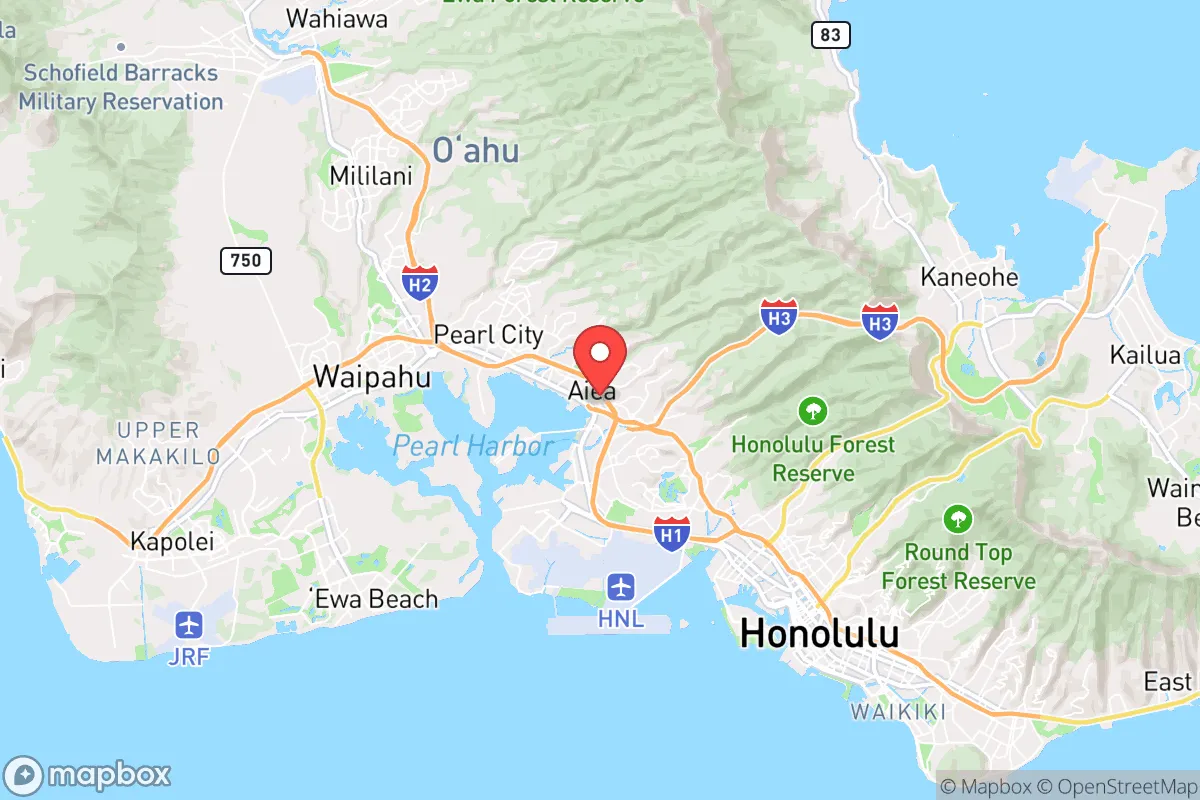
Strategic Assessment of Aiea, HI
Multiple tactical vulnerabilities. Population density, target proximity, or disaster risk are likely compounding. A retreat property and exit planning is required.
What does the Strategic Assessment tell us?
Our Strategic Assessment grades tactical survivability of an area. Major population centers, military targets, fallout zones, natural disasters, and border exposure all drive risk — lower exposure means a more defensible position in a crisis.
This is heavily inspired by Joel Skousen's Strategic Relocation book. Highly recommended you checkout the book ($)What does this tell us?
Our Strategic Assessment grades tactical survivability of an area. Major population centers, military targets, fallout zones, natural disasters, and border exposure all drive risk — lower exposure means a more defensible position in a crisis.
This is heavily inspired by Joel Skousen's Strategic Relocation book. Highly recommended you checkout the book ($)Strategic Pillars

Key Distances
Regional Safe Places
Below is our recommended "safe zones" in Hawaii and the surrounding area based on our strategic heuristics. For most people, it's unrealistic to live in a “safe zone” full-time due to work, family or other personal reasons. They tend to be more rural. However, many of these areas are perfect for second homes and retreat properties that double as a vacation home or even a short-term rental.


Important Note: For informational purposes only. This does not mean nothing bad ever happens in the green zones. Please use common sense. This is based on public data and modeled with AI. We tried to take a conservative approach but mistakes happen. We update this regularly as new information becomes available.
Solar Generator Recommendations
Backup power matters more here than in safer locations. We've picked three solar generators across budgets and capacity tiers — start with the budget unit if you only need a few essentials, or step up if you want to run a fridge and HVAC for days at a time.

Jackery Portable Power Station Explorer 300
Budget OptionPower on the Go: Weighing only 11 lbs, it's convenient to set up and store with book-sized foldable solar panels

BLUETTI Portable Power Station AC180
Designed for both indoor and outdoor scenarios, AC180 is highly capable as it has a robost capacity and continuous output power.

EF ECOFLOW DELTA Pro Ultra Power Station
Upgraded PickEcoFlow DELTA Pro Ultra is a whole-home energy system designed to grow with your family. Integrated with the Smart Home Panel 2, it scales to meet your evolving energy needs — keeping your home powered, intelligent, and secure through every stage of life.
We earn a commission, at no additional cost to you.
Strategic Assessment Analysis
Aiea, Hawaii presents a complex strategic picture for the conservative prepper. Its location on the leeward side of Oahu offers some natural protection from prevailing weather, but its proximity to Pearl Harbor, Joint Base Pearl Harbor-Hickam, and downtown Honolulu places it squarely in a high-risk zone for any major geopolitical or domestic disruption. The area’s resilience is a double-edged sword: you get the logistical advantages of being near a major port and military hub, but you also inherit the target profile that comes with it. For a single individual or family looking to ride out societal collapse, Aiea is less a bunker and more a forward operating base—useful, but only if you understand the risks and have a plan to move inland or to a secondary location when things go sideways.
Geographic position and natural advantages for long-term survival
Aiea sits on the southern coast of Oahu, nestled between the Waianae and Koolau mountain ranges. This position gives it a moderate microclimate with less rainfall than windward areas, which is a practical advantage for gardening and rainwater catchment if you can secure the space. The elevation climbs quickly as you move north into Aiea Heights, offering some terrain-based defensibility and cooler temperatures that reduce heat stress during a grid-down scenario. The area’s proximity to Pearl Harbor and the H-1 freeway means you have rapid access to the ocean for fishing and the mountains for foraging, but that same connectivity makes it a chokepoint during any evacuation. The natural harbor and deep-water channels are strategic assets for trade or resupply in a crisis, but they also make Aiea a likely staging area for military or federal operations, which could bring unwanted attention. For a prepper, the key takeaway is that Aiea’s geography is a mixed bag—good for short-term resource gathering, but not ideal for a long-term hideout.
Risks, exposures, and proximity to fallout-relevant landmarks
The biggest strategic liability of Aiea is its proximity to high-value targets. Joint Base Pearl Harbor-Hickam is less than three miles away, and the harbor itself is a primary logistics hub for the Pacific Fleet. In any major conflict—whether with China, North Korea, or a domestic insurgency—this area would be a first-strike or sabotage target. The fallout from a conventional or EMP attack would render Aiea uninhabitable for weeks or months, and the radiation plume from a nuclear detonation at the harbor would sweep directly over the town depending on wind direction. Beyond military threats, Aiea sits in a tsunami inundation zone; a major seismic event in the Aleutian Trench could send a wave over the low-lying areas near the coast. The Ala Wai Canal and Pearl Harbor itself are also vulnerable to industrial spills or sabotage of fuel storage facilities. For a conservative prepper, the calculus is simple: you are living next to a bullseye. The only mitigating factor is that Aiea’s hillside neighborhoods offer some elevation, but the majority of the population lives within a mile of the water. If you are considering Aiea, you need a bug-out plan that gets you to the North Shore or the Big Island within 24 hours.
Practical resilience for a relocator: food, water, energy, and defensibility
Daily life in Aiea for a prepper requires a self-sufficiency mindset because the local infrastructure is fragile. The power grid is island-wide and vulnerable to storms, fuel shortages, and cyberattacks; a single downed line can leave parts of Aiea without electricity for days. Water comes from the Board of Water Supply, which relies on pumped groundwater and reservoirs—if the pumps stop, you have about 48 hours of pressure. Rainwater catchment is feasible in the hills but not in the dense neighborhoods near the highway. Food security is a major concern: Aiea has a few grocery stores like Times and Foodland, but supply chains are heavily dependent on container ships. A port closure or labor strike would empty shelves within a week. Gardening space is limited in most residential lots, though some homes in Aiea Heights have enough yard for raised beds. Defensibility is poor in the flat areas—your neighbors are close, and the streets are narrow, making it easy for a mob or looters to trap you. The hillside homes offer better sightlines and natural barriers, but they also have limited escape routes. For energy, solar panels are a good investment, but you will need battery storage because the grid is unreliable. A generator is essential, but fuel storage is restricted in many HOAs. The practical reality is that Aiea is a place to live before things fall apart, not during. If you are a single person or a family with the resources to maintain a low profile and stockpile supplies, you can make it work for a few months. But for long-term resilience, you are better off looking at the Big Island or Kauai.
The overall strategic picture for Aiea is that it offers convenience and access to resources, but at a steep risk premium. For a conservative prepper who values community and wants to be near military infrastructure for potential protection, it might seem appealing. But the reality is that Aiea is a high-density, high-target area with limited escape routes and fragile supply lines. If you are serious about surviving a major societal disruption—whether from war, economic collapse, or natural disaster—Aiea should be a temporary staging point, not a permanent retreat. The smart play is to use it as a base to build relationships and gather intelligence, then relocate to a more defensible location when the indicators turn red. If you are set on Oahu, look at the rural areas of the North Shore or the windward side, where you have more land, less population density, and better natural barriers. Aiea is a place to pass through, not to dig in.
* Values derived from national, state, county, city and local statistics and may differ in a specific area. Last updated: 2026-05-04T02:33:39.000Z
Narrative content on this page is AI-generated and may contain mistakes. Verify any details that matter before acting on them.
ReloMaps may earn a commission from affiliate links at no extra cost to you.