
Photo: Wikipedia
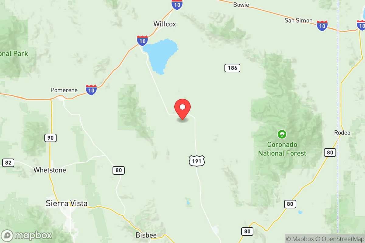
Strategic Assessment of Cochise County
Workable tactical position. Some exposure to population density or targets, but generally defensible in a crisis.
What does the Strategic Assessment tell us?
Our Strategic Assessment grades tactical survivability of an area. Major population centers, military targets, fallout zones, natural disasters, and border exposure all drive risk — lower exposure means a more defensible position in a crisis.
This is heavily inspired by Joel Skousen's Strategic Relocation book. Highly recommended you checkout the book ($)What does this tell us?
Our Strategic Assessment grades tactical survivability of an area. Major population centers, military targets, fallout zones, natural disasters, and border exposure all drive risk — lower exposure means a more defensible position in a crisis.
This is heavily inspired by Joel Skousen's Strategic Relocation book. Highly recommended you checkout the book ($)Strategic Pillars

Key Distances
Strategic Assessment Analysis
Cochise County, Arizona, offers a compelling strategic position for those prioritizing resilience and distance from the most likely flashpoints of national instability. Its location in the southeastern corner of the state places it far from the congested, high-risk corridors of Phoenix and Tucson, while still providing access to essential infrastructure and a deeply rooted, self-reliant culture. The county's combination of a dry climate, defensible terrain, and a population that leans heavily toward independence and conservative values makes it a serious candidate for a relocation base, particularly for individuals and families who view preparedness as a core lifestyle principle.
Geographic position and natural advantages for long-term security
Cochise County's geography is its first and most significant asset. The county is anchored by the city of Sierra Vista, which sits at roughly 4,600 feet in elevation on the eastern slope of the Huachuca Mountains. This elevation provides a moderate climate that avoids the extreme summer heat of the lower desert valleys, reducing water demand and making off-grid living more feasible. The county is bordered to the east by the San Bernardino Valley and the Peloncillo Mountains, creating a natural buffer zone between the population centers of Arizona and the more volatile border region. To the west, the Dragoon Mountains and Whetstone Mountains offer rugged, defensible terrain and numerous canyons and valleys that are difficult to access without local knowledge. The San Pedro River, one of the last free-flowing rivers in the Southwest, runs north-south through the county, providing a rare and reliable surface water source in an otherwise arid region. This river corridor is a critical natural resource for any long-term resilience plan, supporting riparian habitat and offering potential for small-scale irrigation. The county's position also places it roughly 70 miles from the Douglas port of entry and 80 miles from Nogales, meaning it is close enough to monitor border activity but far enough from the immediate chaos of a major crossing point. For a relocator, the key takeaway is that Cochise County sits in a sweet spot: remote enough to avoid the first wave of any urban collapse, but connected enough to maintain supply lines and communication.
Risks, exposures, and proximity to fallout-relevant landmarks
No strategic assessment is complete without a clear-eyed look at the risks. The most obvious exposure is the international border. The county shares a roughly 80-mile border with Mexico, and while the terrain is rugged, it is not impermeable. The Douglas and Naco ports of entry are potential chokepoints for both legitimate traffic and illicit movement. In a scenario of widespread civil unrest or a breakdown of federal authority, the border could become a vector for uncontrolled migration, cartel activity, or even military incursions. This is not a theoretical risk; the county has experienced periodic surges in border crossings and associated crime. However, the local population is acutely aware of this, and the Cochise County Sheriff's Office and local ranchers maintain a high level of vigilance and operational capability. The presence of Fort Huachuca, a major U.S. Army installation just west of Sierra Vista, is a double-edged sword. On one hand, it brings a significant military and intelligence community presence, which can provide a stabilizing force and a pool of skilled, security-minded residents. On the other hand, Fort Huachuca is a potential target for any adversary seeking to disrupt U.S. communications and intelligence networks. The base is home to the U.S. Army Intelligence Center of Excellence and the Network Enterprise Technology Command, making it a high-value asset. A relocator must weigh the benefits of living near a military base against the increased probability of that area being a target in a major conflict. There are no major refineries, nuclear power plants, or large-scale chemical facilities within the county, which is a significant positive. The nearest major industrial target is likely the Palo Verde Nuclear Generating Station near Phoenix, roughly 180 miles northwest, or the Davis-Monthan Air Force Base in Tucson, about 70 miles northwest. Both are far enough to avoid direct fallout or blast effects from a conventional strike, but a major event at either could still disrupt supply chains and power grids that reach Cochise County.
Practical resilience for a relocator: food, water, energy, and defensibility
For a family or individual looking to establish a resilient homestead, Cochise County offers a mix of advantages and challenges that require serious planning. Water is the primary concern. The county is in a high desert, with annual precipitation averaging around 15 inches in the lower elevations and up to 25 inches in the Huachuca Mountains. The San Pedro River is a perennial water source, but accessing it legally and sustainably requires land ownership along its corridor, which is expensive and heavily regulated. Most residential wells in the Sierra Vista area draw from the Upper San Pedro Basin, which is experiencing long-term groundwater depletion due to population growth and agricultural use. A relocator should budget for a deep well (300-500 feet) and consider rainwater harvesting as a primary backup. The county's building codes in unincorporated areas are relatively lax, allowing for the construction of cisterns and off-grid water systems without excessive permitting. Food production is viable but limited by the growing season, which runs from April to October in the lower valleys and May to September at higher elevations. The Sulphur Springs Valley, east of the Dragoon Mountains, is a major agricultural area, producing hay, corn, and livestock. Local farmers' markets in Bisbee and Sierra Vista provide access to fresh produce, but a serious prepper should plan to establish their own garden and consider raising small livestock like chickens or goats. The county's rural nature means that most residents are accustomed to some level of self-sufficiency, and there is a strong network of local ranchers and farmers who trade goods and knowledge. Energy is a bright spot. The county averages over 280 sunny days per year, making solar power a highly reliable option. Net metering is available through UniSource Energy Services and Sulphur Springs Valley Electric Cooperative, but a truly resilient setup should include battery storage and a backup generator, as grid outages can occur during monsoon storms or wildfire seasons. Defensibility is excellent in the mountainous areas. Properties in the Huachuca and Dragoon foothills offer natural chokepoints, long sightlines, and limited access roads. A well-chosen property with a single, gated entrance and a reliable water source can be made very secure. The local culture is heavily armed and pro-Second Amendment, which means that in a crisis, the community is likely to organize for mutual defense rather than rely on distant law enforcement.
The overall strategic picture for Cochise County is one of high potential tempered by real, manageable risks. It is not a bug-out location for a weekend warrior; it is a place for a serious, long-term commitment to a self-reliant lifestyle. The county offers a rare combination of defensible terrain, a reliable water source in the San Pedro River, a climate that supports year-round habitation, and a population that is already oriented toward independence and preparedness. The proximity to the border and the presence of Fort Huachuca are the two factors that demand the most attention. A relocator who chooses a property in the northern or western parts of the county, away from the border and with good access to the mountains, can mitigate the border risk significantly. The Fort Huachuca risk is harder to avoid, but the base also provides a steady economic base and a community of people with security clearances and tactical skills. For a conservative-leaning individual or family who sees the current national trajectory as unstable and wants a place where they can build a resilient, independent life, Cochise County deserves a top spot on the short list. It is not a perfect sanctuary, but in a world of imperfect options, it is one of the most strategically sound pieces of ground in the American Southwest.
* Values derived from national, state, county, city and local statistics and may differ in a specific area. Last updated: 2026-05-14T12:26:00.000Z
Narrative content on this page is AI-generated and may contain mistakes. Verify any details that matter before acting on them.
ReloMaps may earn a commission from affiliate links at no extra cost to you.