Photo: Wikipedia
Strategic Assessment of Batesville, AR
Workable tactical position. Some exposure to population density or targets, but generally defensible in a crisis.
What does the Strategic Assessment tell us?
Our Strategic Assessment grades tactical survivability of an area. Major population centers, military targets, fallout zones, natural disasters, and border exposure all drive risk — lower exposure means a more defensible position in a crisis.
This is heavily inspired by Joel Skousen's Strategic Relocation book. Highly recommended you checkout the book ($)What does this tell us?
Our Strategic Assessment grades tactical survivability of an area. Major population centers, military targets, fallout zones, natural disasters, and border exposure all drive risk — lower exposure means a more defensible position in a crisis.
This is heavily inspired by Joel Skousen's Strategic Relocation book. Highly recommended you checkout the book ($)Strategic Pillars

Key Distances
Regional Safe Places
Below is our recommended "safe zones" in Arkansas and the surrounding area based on our strategic heuristics. For most people, it's unrealistic to live in a “safe zone” full-time due to work, family or other personal reasons. They tend to be more rural. However, many of these areas are perfect for second homes and retreat properties that double as a vacation home or even a short-term rental.


Important Note: For informational purposes only. This does not mean nothing bad ever happens in the green zones. Please use common sense. This is based on public data and modeled with AI. We tried to take a conservative approach but mistakes happen. We update this regularly as new information becomes available.
Solar Generator Recommendations
Backup power matters more here than in safer locations. We've picked three solar generators across budgets and capacity tiers — start with the budget unit if you only need a few essentials, or step up if you want to run a fridge and HVAC for days at a time.

Jackery Portable Power Station Explorer 300
Budget OptionPower on the Go: Weighing only 11 lbs, it's convenient to set up and store with book-sized foldable solar panels

BLUETTI Portable Power Station AC180
Designed for both indoor and outdoor scenarios, AC180 is highly capable as it has a robost capacity and continuous output power.

EF ECOFLOW DELTA Pro Ultra Power Station
Upgraded PickEcoFlow DELTA Pro Ultra is a whole-home energy system designed to grow with your family. Integrated with the Smart Home Panel 2, it scales to meet your evolving energy needs — keeping your home powered, intelligent, and secure through every stage of life.
We earn a commission, at no additional cost to you.
Strategic Assessment Analysis
Batesville, Arkansas, offers a compelling strategic position for those prioritizing resilience and long-term stability, combining a strong local economy with a location that balances rural security and regional access. Situated in the Ozark foothills along the White River, this county seat of Independence County has historically weathered economic shifts and natural events with a steady, self-reliant character. For a relocator with a prepper or survivalist mindset, Batesville presents a viable base of operations that is far enough from major metropolitan chaos to offer breathing room, yet close enough to supply lines and medical infrastructure to be practical.
Geographic position and natural advantages for long-term security
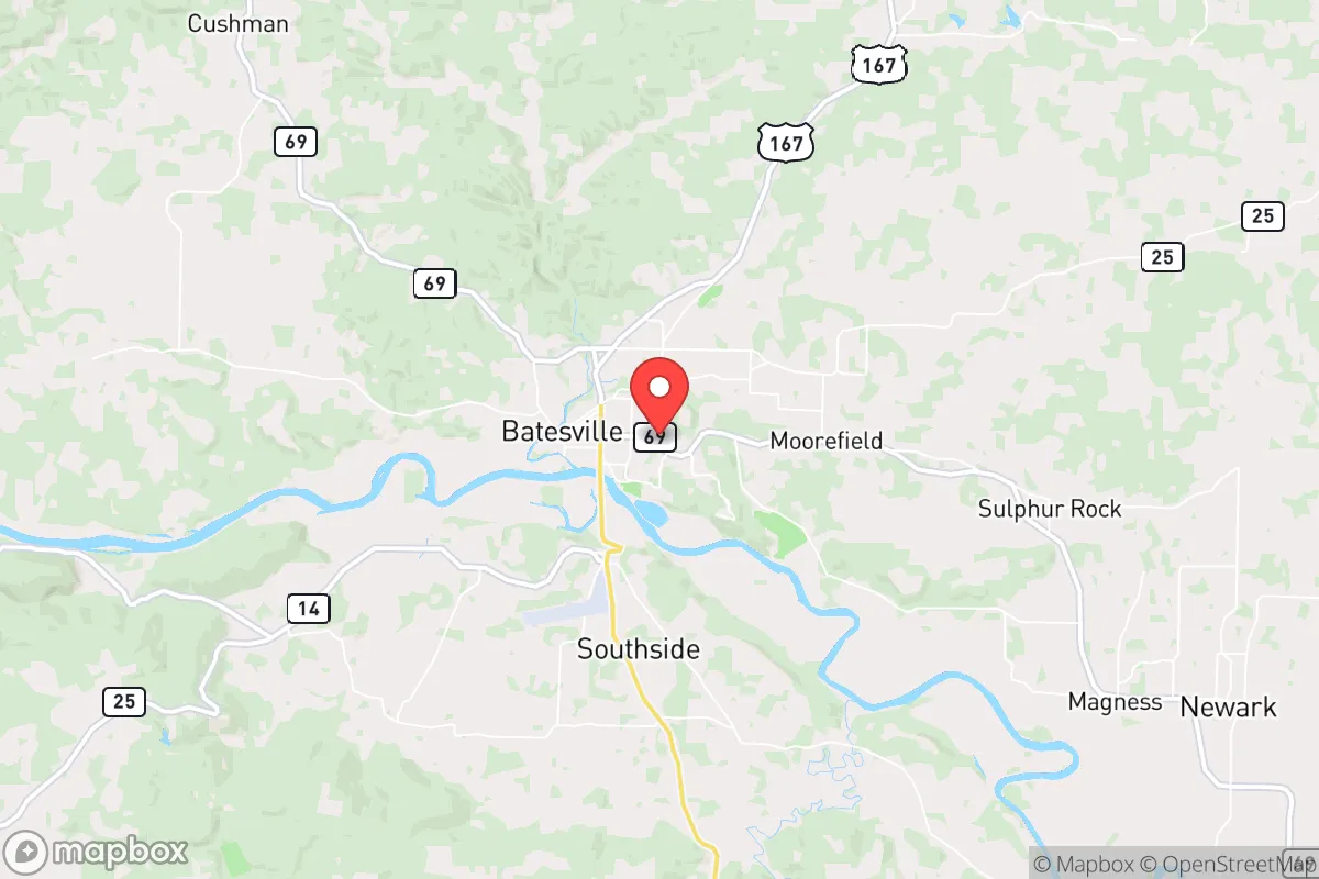
Batesville’s geography is its first line of defense. The city sits roughly 90 miles northeast of Little Rock and about 100 miles west of Memphis, Tennessee—close enough for occasional supply runs or specialized medical care, but far enough that the immediate fallout from a major urban crisis (civil unrest, grid collapse, or a mass casualty event) would likely be diluted by distance and rural buffer zones. The surrounding terrain is rolling hills and hardwood forests, offering natural cover, defensible chokepoints on rural roads, and ample watershed. The White River, which runs through the city, is a perennial water source that doesn’t dry up in drought years—a critical asset for off-grid water planning. The area sits outside the primary tornado alley’s most violent corridor, though severe weather is still a factor; the local topography helps break up storm systems compared to the flatlands to the west. Elevation averages around 340 feet, with higher ground to the north and east providing good vantage points and reduced flood risk for those choosing property wisely.
Risks, exposures, and proximity to fallout-relevant landmarks
No location is without vulnerabilities, and Batesville has a few that demand attention. The city itself is home to a major industrial employer—the White River Lock and Dam (a U.S. Army Corps of Engineers facility) and several manufacturing plants, including a large Unilever facility and a FutureFuel Chemical Company plant. FutureFuel is a chemical manufacturer that produces biodiesel and specialty chemicals; while not a nuclear target, any industrial accident or intentional sabotage could release hazardous materials. The lock and dam on the White River is a potential chokepoint for river traffic and a target for disruption, but it’s not a high-value strategic asset likely to draw a direct strike. More concerning is the proximity to Little Rock Air Force Base (about 70 miles southwest), which hosts C-130 operations and is a potential target in a major conflict. Batesville is outside the immediate blast and fallout zones for a strike on that base, but prevailing winds from the southwest could carry fallout toward the area in a worst-case scenario. The city is also within 150 miles of the Fort Chaffee training area and the Arkansas Nuclear One power plant near Russellville (about 120 miles west). A catastrophic failure at that plant could affect the region depending on wind patterns, but Batesville is far enough to avoid the most severe contamination zones. For civil unrest, the city’s population of roughly 11,000 means any large-scale protest or riot would likely be small and manageable, but the nearby University of Arkansas Community College at Batesville could be a flashpoint if national tensions escalate. The biggest practical risk is flooding along the White River—the city has experienced major floods in 2019 and 2021, so any property purchase should be carefully vetted against FEMA flood maps.
Practical resilience for a relocator: food, water, energy, and defensibility
For someone serious about self-sufficiency, Batesville offers strong fundamentals. Water is abundant: the White River is a reliable surface source, and the Ozark aquifer system provides good well water in most areas outside the immediate floodplain. The city’s municipal water comes from the river, but a private well with a hand pump or solar-powered pump is a wise backup. Food production is viable—the growing season runs about 210 days, with fertile river-bottom soil and plenty of acreage available for gardens, orchards, and small livestock. Local farmers’ markets and the Independence County Cooperative Extension office provide resources for heirloom seeds and sustainable practices. Hunting is permitted on public lands in the Ozark National Forest (about 30 miles north) and on private land with permission; deer, turkey, and small game are plentiful. Energy resilience is improving: the area has decent solar insolation (about 4.5 peak sun hours per day on average), and many rural properties already have backup generators due to occasional ice storms knocking out grid power. Wood heating is common, with abundant hardwood timber for fuel. Defensibility is a mixed bag. The city itself is laid out along the river and major highways (US-167 and AR-25), which are natural ingress routes for outsiders. For a more secure homestead, look to the rural areas north of town toward the White River bluffs or east toward the Strawberry River valley—these areas offer dead-end roads, hilltop views, and natural barriers. The local gun culture is strong and supportive; Independence County has a high rate of firearm ownership and a sheriff’s office that is generally pro-Second Amendment. There are several gun shops and ranges within a 30-minute drive, and the local community is accustomed to self-reliance. Medical infrastructure is adequate for daily needs: White River Medical Center is a 100+ bed facility with an emergency room and surgical capabilities, but for major trauma or specialized care, you’re looking at a 90-minute drive to Little Rock. Stockpiling antibiotics, trauma supplies, and having a telemedicine plan is prudent.
The overall strategic picture for Batesville is one of balanced viability. It’s not a hardened bunker location, nor is it a remote wilderness retreat—it’s a functional, middle-American town with enough resources and distance from major targets to serve as a solid base for a prepared individual or family. The local economy is diversified enough to weather recessions (manufacturing, healthcare, education, and agriculture), and the community is politically and culturally aligned with conservative values of self-reliance and mutual aid. The biggest drawbacks are the industrial hazards from the chemical plant and the flood risk along the river, both of which can be mitigated with careful site selection. For someone looking to relocate with an eye toward long-term stability, civic resilience, and the ability to ride out national-level disruptions, Batesville deserves serious consideration. It’s not flashy, but it’s solid—and in a world where flashy often means fragile, solid is exactly what you want.
* Values derived from national, state, county, city and local statistics and may differ in a specific area. Last updated: 2026-04-30T04:39:08.000Z
Narrative content on this page is AI-generated and may contain mistakes. Verify any details that matter before acting on them.
ReloMaps may earn a commission from affiliate links at no extra cost to you.