Photo: Wikipedia
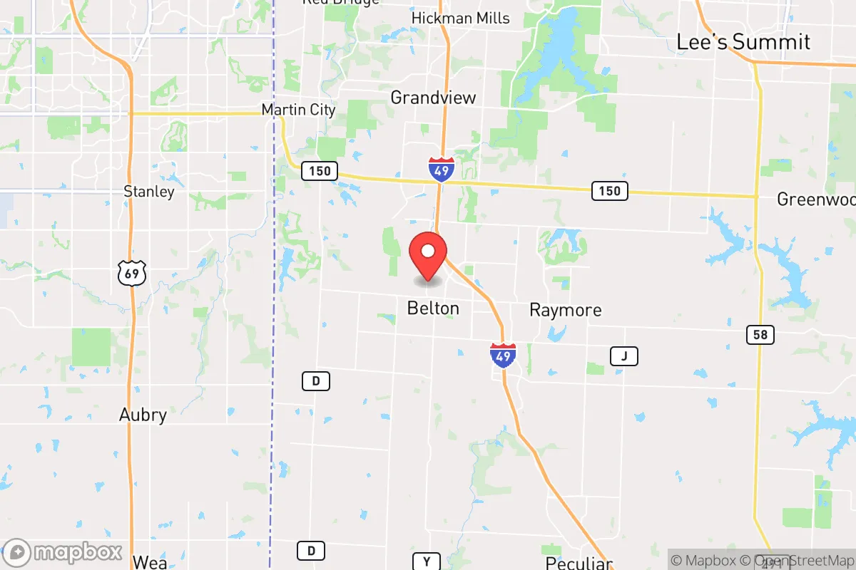
Strategic Assessment of Belton, MO
Meaningful friction. Expect exposure to either population pressure, blast zones, or natural disaster risk. Consider buying a retreat property.
What does the Strategic Assessment tell us?
Our Strategic Assessment grades tactical survivability of an area. Major population centers, military targets, fallout zones, natural disasters, and border exposure all drive risk — lower exposure means a more defensible position in a crisis.
This is heavily inspired by Joel Skousen's Strategic Relocation book. Highly recommended you checkout the book ($)What does this tell us?
Our Strategic Assessment grades tactical survivability of an area. Major population centers, military targets, fallout zones, natural disasters, and border exposure all drive risk — lower exposure means a more defensible position in a crisis.
This is heavily inspired by Joel Skousen's Strategic Relocation book. Highly recommended you checkout the book ($)Strategic Pillars

Key Distances
Regional Safe Places
Below is our recommended "safe zones" in Missouri and the surrounding area based on our strategic heuristics. For most people, it's unrealistic to live in a “safe zone” full-time due to work, family or other personal reasons. They tend to be more rural. However, many of these areas are perfect for second homes and retreat properties that double as a vacation home or even a short-term rental.


Important Note: For informational purposes only. This does not mean nothing bad ever happens in the green zones. Please use common sense. This is based on public data and modeled with AI. We tried to take a conservative approach but mistakes happen. We update this regularly as new information becomes available.
Solar Generator Recommendations
Backup power matters more here than in safer locations. We've picked three solar generators across budgets and capacity tiers — start with the budget unit if you only need a few essentials, or step up if you want to run a fridge and HVAC for days at a time.

Jackery Portable Power Station Explorer 300
Budget OptionPower on the Go: Weighing only 11 lbs, it's convenient to set up and store with book-sized foldable solar panels

BLUETTI Portable Power Station AC180
Designed for both indoor and outdoor scenarios, AC180 is highly capable as it has a robost capacity and continuous output power.

EF ECOFLOW DELTA Pro Ultra Power Station
Upgraded PickEcoFlow DELTA Pro Ultra is a whole-home energy system designed to grow with your family. Integrated with the Smart Home Panel 2, it scales to meet your evolving energy needs — keeping your home powered, intelligent, and secure through every stage of life.
We earn a commission, at no additional cost to you.
Strategic Assessment Analysis
Belton, Missouri, sits in a precarious but potentially rewarding position for the strategic relocator. Located roughly 25 miles south of downtown Kansas City along the I-49 corridor, it offers a buffer from the immediate chaos of a major metro while still being close enough to be affected by its collapse. For the prepper or survivalist, the key question isn't whether Belton is a perfect fortress—it isn't—but whether its specific mix of proximity, infrastructure, and community resilience provides a viable base for weathering the storms ahead. The answer is a qualified yes, provided you understand the trade-offs and plan accordingly.
Geographic position and natural advantages for long-term survival
Belton’s location is its strongest card, but it’s a double-edged sword. The city sits on the western edge of the Ozark Plateau, where the flat agricultural plains of western Missouri begin to roll into the more wooded, hilly terrain to the south and east. This transition zone offers a mix of open farmland for potential self-sufficiency and wooded cover for retreat or concealment. The area is drained by the South Grand River and several smaller creeks, providing surface water sources that are more reliable than the arid West but less abundant than the Ozarks proper. For a relocator, this means you have a realistic shot at drilling a well or developing a rainwater catchment system without fighting bedrock or extreme drought, though water table depth varies. The soil in Cass County is generally productive loam, suitable for market gardening or subsistence farming, which is a significant advantage over rocky or sandy regions. The climate is four-season, with hot, humid summers and cold winters, but it avoids the extremes of tornado alley’s core or the deep freeze of the northern plains. This makes extended grid-down living more feasible than in harsher biomes, though you’ll still need to plan for seasonal extremes.
Risks, exposures, and proximity to fallout-relevant landmarks
Here’s where the analysis gets sobering. Belton’s proximity to Kansas City is the primary strategic liability. Kansas City is a Tier 1 target in any major conflict scenario, hosting a Federal Reserve Bank, major transportation hubs (including the nation’s second-largest rail center by tonnage), and critical infrastructure like the BNSF intermodal facility and multiple power plants. A single airburst or ground burst over downtown KC would produce fallout that could reach Belton within hours, depending on wind direction. The prevailing winds are from the south and southwest, which is marginally favorable—fallout from a strike on KC would likely drift northeast, away from Belton. But a strike on Whiteman Air Force Base (home to the B-2 Spirit bomber), located about 50 miles east-southeast near Knob Noster, is a more direct threat. Prevailing winds from the southwest would carry fallout from Whiteman directly toward the Belton area. You need a fallout shelter plan, not just a bug-out bag, if you’re serious about this location. Beyond nuclear risk, Belton is in a region prone to severe thunderstorms, hail, and the occasional tornado—the 2003 Belton tornado was an F3 that caused significant damage. Flooding along the South Grand River is a periodic concern for low-lying properties. Civil unrest spilling out of Kansas City is a realistic scenario; the 2020 riots in KC saw looting and arson that reached the southern suburbs, and Belton’s position along I-49 makes it a natural corridor for both evacuees and looters. The city’s police department is small (around 30 officers), and mutual aid from surrounding agencies would be strained in a regional crisis.
Practical resilience for a relocator: food, water, energy, and defensibility
For the individual or family looking to establish a resilient homestead, Belton offers a mixed bag. Water is the first concern. Municipal water comes from the Missouri River via Kansas City’s system, which is vulnerable to both contamination and infrastructure failure. A private well is the gold standard here, and many properties in the rural parts of Cass County have them. If you’re buying in town, you’ll need to plan for storage and filtration. The average annual rainfall is about 40 inches, making rainwater collection a viable secondary source. Food production is feasible but requires work. The growing season runs roughly April through October, and the soil is good for vegetables, fruit trees, and small grains. Local ordinances in Belton allow for backyard chickens and small livestock, though you’ll want to check HOA covenants if you’re in a subdivision. For larger animals like goats or cattle, you need to be outside city limits. The area has a strong agricultural heritage, so knowledge and supplies (seeds, tools, feed) are available locally—a non-trivial advantage. Energy resilience is a weak point. The grid is served by Evergy, which has a mixed reliability record. Solar is viable, with about 200 sunny days per year, but you’ll need battery storage and a backup generator for the cloudy stretches. Natural gas is available in town, but a propane tank is the better bet for off-grid cooking and heating. Wood heating is possible if you have land, but the local timber is mostly oak and hickory—good burning, but you’ll need to manage your supply. Defensibility is the hardest variable. Belton is not a natural fortress. It’s a flat to gently rolling landscape with open sightlines and a grid of county roads. A rural property with a long driveway, perimeter fencing, and a good line of sight to approach routes is your best bet. The town itself is too porous to hold against a determined group, but a well-prepared household on the outskirts can be very hard to approach without warning. The local gun culture is strong—Missouri is a constitutional carry state—and the Cass County Sheriff’s office is generally supportive of Second Amendment rights. You won’t be alone in your preparations, which is both a comfort and a potential source of competition for resources.
The overall strategic picture for Belton is one of calculated risk. It offers a realistic path to self-sufficiency in a moderate climate with decent soil and water access, all within a region that still values independence and preparedness. But it sits in the shadow of a major target and on a corridor that will see heavy traffic in any crisis. This is not a retreat location for those seeking total isolation; it’s a forward operating base for those who want to stay close enough to the region’s resources while maintaining a buffer. If you’re willing to invest in a fallout shelter, a well, and a solid perimeter, Belton can work. If you’re looking for a remote mountain hideout, keep driving south. For the strategic relocator who understands that no location is perfect, Belton is a defensible compromise—but only if you go in with eyes wide open and a plan for the worst-case scenarios.
* Values derived from national, state, county, city and local statistics and may differ in a specific area. Last updated: 2026-04-29T20:35:49.000Z
Narrative content on this page is AI-generated and may contain mistakes. Verify any details that matter before acting on them.
ReloMaps may earn a commission from affiliate links at no extra cost to you.