
Photo: Wikipedia
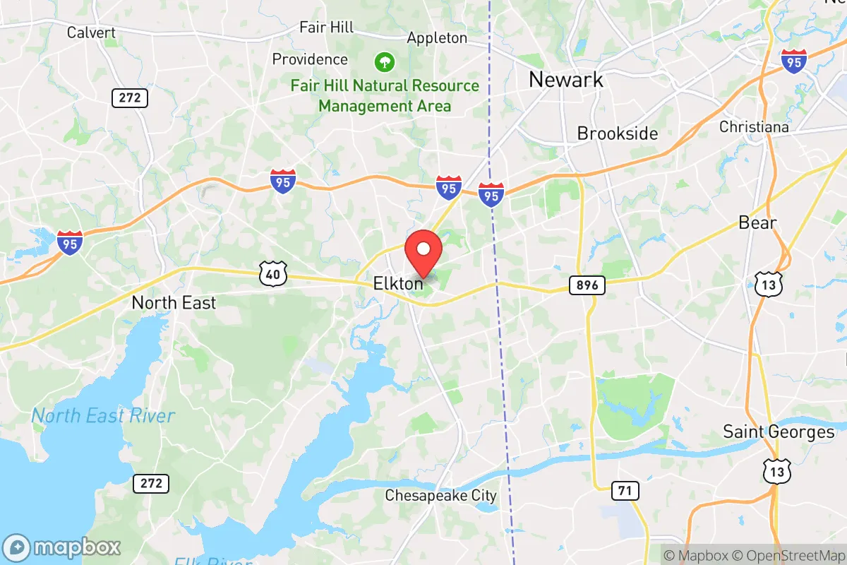
Strategic Assessment of Elkton, MD
Multiple tactical vulnerabilities. Population density, target proximity, or disaster risk are likely compounding. A retreat property and exit planning is required.
What does the Strategic Assessment tell us?
Our Strategic Assessment grades tactical survivability of an area. Major population centers, military targets, fallout zones, natural disasters, and border exposure all drive risk — lower exposure means a more defensible position in a crisis.
This is heavily inspired by Joel Skousen's Strategic Relocation book. Highly recommended you checkout the book ($)What does this tell us?
Our Strategic Assessment grades tactical survivability of an area. Major population centers, military targets, fallout zones, natural disasters, and border exposure all drive risk — lower exposure means a more defensible position in a crisis.
This is heavily inspired by Joel Skousen's Strategic Relocation book. Highly recommended you checkout the book ($)Strategic Pillars

Key Distances
Regional Safe Places
Below is our recommended "safe zones" in Maryland and the surrounding area based on our strategic heuristics. For most people, it's unrealistic to live in a “safe zone” full-time due to work, family or other personal reasons. They tend to be more rural. However, many of these areas are perfect for second homes and retreat properties that double as a vacation home or even a short-term rental.


Important Note: For informational purposes only. This does not mean nothing bad ever happens in the green zones. Please use common sense. This is based on public data and modeled with AI. We tried to take a conservative approach but mistakes happen. We update this regularly as new information becomes available.
Solar Generator Recommendations
Backup power matters more here than in safer locations. We've picked three solar generators across budgets and capacity tiers — start with the budget unit if you only need a few essentials, or step up if you want to run a fridge and HVAC for days at a time.

Jackery Portable Power Station Explorer 300
Budget OptionPower on the Go: Weighing only 11 lbs, it's convenient to set up and store with book-sized foldable solar panels

BLUETTI Portable Power Station AC180
Designed for both indoor and outdoor scenarios, AC180 is highly capable as it has a robost capacity and continuous output power.

EF ECOFLOW DELTA Pro Ultra Power Station
Upgraded PickEcoFlow DELTA Pro Ultra is a whole-home energy system designed to grow with your family. Integrated with the Smart Home Panel 2, it scales to meet your evolving energy needs — keeping your home powered, intelligent, and secure through every stage of life.
We earn a commission, at no additional cost to you.
Strategic Assessment Analysis
Elkton, Maryland, sits in a precarious but potentially advantageous position for those prioritizing resilience and strategic relocation. Its location at the head of the Chesapeake Bay, straddling the I-95 corridor between Philadelphia and Baltimore, offers both critical access and significant exposure. For a prepper or survivalist with a conservative worldview, the key question is whether this small town’s geographic advantages outweigh its proximity to major population centers and their associated risks. The answer is nuanced: Elkton provides a solid base for those who understand its vulnerabilities and are willing to actively manage them, but it is not a remote bug-out location.
Geographic position and natural advantages for long-term resilience
Elkton’s primary strategic asset is its location at the nexus of multiple transportation and natural corridors. It sits on the Elk River, a tidal tributary of the Chesapeake Bay, providing direct water access for fishing, transport, and potential escape routes. The surrounding Cecil County is a mix of farmland, forest, and small towns, offering a degree of rural buffer that is increasingly rare along the Northeast megalopolis. The area’s proximity to the Susquehanna River and the Conowingo Dam (about 15 miles north) means a reliable freshwater source, though the dam itself is a critical infrastructure point. The local topography is gently rolling, with no major mountain barriers, but the numerous creeks and wetlands create natural chokepoints and defensible positions for those who know the land. The climate is temperate, with four distinct seasons, allowing for year-round gardening and livestock management, though winters can be cold enough to stress unprepared systems. For a relocator, the ability to tap into both freshwater and tidal resources, combined with arable land within a 20-minute drive of town, is a significant plus.
Risks, exposures, and proximity to fallout-relevant landmarks
The most glaring vulnerability for Elkton is its position on the I-95 corridor, a primary evacuation route and target for disruption during any major crisis. The town is roughly 45 miles from both Philadelphia and Baltimore, placing it within the blast and fallout zones of any nuclear or radiological event targeting those cities. The nearby Perryville train derailment history and the constant flow of hazardous materials on I-95 and the CSX rail line mean chemical spills or industrial accidents are a real, recurring risk. The Conowingo Dam, while a water source, is also a high-value target for sabotage or natural failure, which could flood large portions of the lower Susquehanna and Elk River valleys. Additionally, the Aberdeen Proving Ground (about 20 miles south) is a major military installation that could become a focal point for federal response or, conversely, a target. The presence of the Peach Bottom Atomic Power Station (about 25 miles west in Pennsylvania) adds a nuclear risk that, while low-probability, is high-consequence. For the conservative prepper, these are not deal-breakers, but they demand a layered defense: a well-stocked bug-out bag, a vehicle capable of leaving the I-95 corridor quickly, and a plan to move north or west into Pennsylvania’s more rural interior if the situation deteriorates.
Practical resilience for a relocator: food, water, energy, and defensibility
For daily life and crisis preparedness, Elkton offers a mixed bag. The local water supply is municipally sourced from the Elk River and groundwater, but a private well is feasible in the outlying areas—a critical advantage for those who want to avoid reliance on a potentially compromised grid. The soil in Cecil County is generally fertile, and there is a strong local farming community, with farmers’ markets and CSAs available. A relocator with land can realistically establish a substantial garden and small livestock operation. Energy-wise, the area is served by Delmarva Power, but grid reliability is average; winter storms and summer heat waves can cause outages. Solar is viable, though the region’s cloud cover reduces efficiency compared to the Southwest. Wood heating is a practical backup, given the forested landscape. Defensibility is moderate: the town itself is a typical small American downtown with limited natural barriers, but the surrounding rural roads offer good fields of fire and limited access points for outsiders. The local gun culture is present but not as pronounced as in the Deep South; Cecil County is a “may-issue” jurisdiction for concealed carry, which requires a demonstrated need, though the legal climate is more favorable than in Baltimore or Philadelphia. The county’s sheriff’s office is generally supportive of Second Amendment rights, but the proximity to Maryland’s restrictive state laws (e.g., magazine capacity limits, handgun roster) is a constant friction point for the serious prepper.
The overall strategic picture for Elkton is one of calculated risk. It is not a remote sanctuary, but it is a viable base for those who want to stay connected to the Northeast’s economic and social fabric while maintaining a credible level of self-sufficiency. The key is to treat Elkton as a forward operating base, not a final redoubt. The smart relocator will invest in a property with a well, septic, and wood heat, establish relationships with local farmers and tradesmen, and have a clear evacuation plan for the worst-case scenarios. The town’s location on the water and near major highways is a double-edged sword: it provides access to resources and escape routes, but also exposes you to the chaos of a collapsing urban corridor. For the conservative individual or family who is willing to put in the work—digging a well, storing food, learning to navigate the local political landscape—Elkton offers a solid, if not spectacular, foundation for resilience. It is a place to live prepared, not a place to hide.
* Values derived from national, state, county, city and local statistics and may differ in a specific area. Last updated: 2026-04-22T03:47:34.000Z
Narrative content on this page is AI-generated and may contain mistakes. Verify any details that matter before acting on them.
ReloMaps may earn a commission from affiliate links at no extra cost to you.