
Photo: Wikipedia
Strategic Assessment of Evanston, WY
Strong survivability profile. Good buffer from population centers, with manageable environmental and tactical risks.
What does the Strategic Assessment tell us?
Our Strategic Assessment grades tactical survivability of an area. Major population centers, military targets, fallout zones, natural disasters, and border exposure all drive risk — lower exposure means a more defensible position in a crisis.
This is heavily inspired by Joel Skousen's Strategic Relocation book. Highly recommended you checkout the book ($)What does this tell us?
Our Strategic Assessment grades tactical survivability of an area. Major population centers, military targets, fallout zones, natural disasters, and border exposure all drive risk — lower exposure means a more defensible position in a crisis.
This is heavily inspired by Joel Skousen's Strategic Relocation book. Highly recommended you checkout the book ($)Strategic Pillars

Key Distances
Regional Safe Places
Below is our recommended "safe zones" in Wyoming and the surrounding area based on our strategic heuristics. For most people, it's unrealistic to live in a “safe zone” full-time due to work, family or other personal reasons. They tend to be more rural. However, many of these areas are perfect for second homes and retreat properties that double as a vacation home or even a short-term rental.
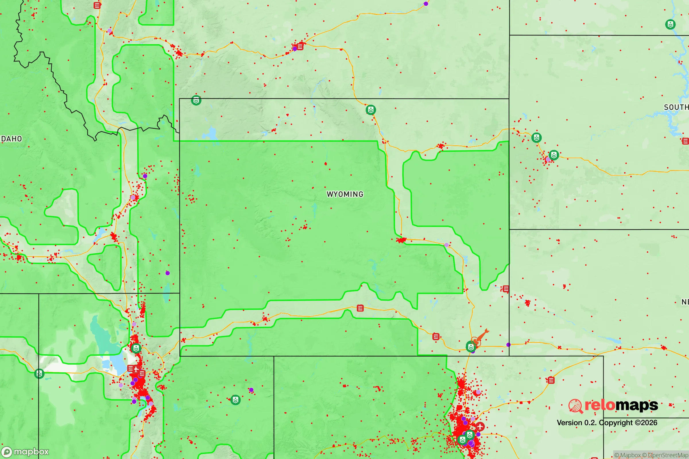
Important Note: For informational purposes only. This does not mean nothing bad ever happens in the green zones. Please use common sense. This is based on public data and modeled with AI. We tried to take a conservative approach but mistakes happen. We update this regularly as new information becomes available.
Solar Generator Recommendations
Backup power matters more here than in safer locations. We've picked three solar generators across budgets and capacity tiers — start with the budget unit if you only need a few essentials, or step up if you want to run a fridge and HVAC for days at a time.

Jackery Portable Power Station Explorer 300
Budget OptionPower on the Go: Weighing only 11 lbs, it's convenient to set up and store with book-sized foldable solar panels

BLUETTI Portable Power Station AC180
Designed for both indoor and outdoor scenarios, AC180 is highly capable as it has a robost capacity and continuous output power.

EF ECOFLOW DELTA Pro Ultra Power Station
Upgraded PickEcoFlow DELTA Pro Ultra is a whole-home energy system designed to grow with your family. Integrated with the Smart Home Panel 2, it scales to meet your evolving energy needs — keeping your home powered, intelligent, and secure through every stage of life.
We earn a commission, at no additional cost to you.
Strategic Assessment Analysis
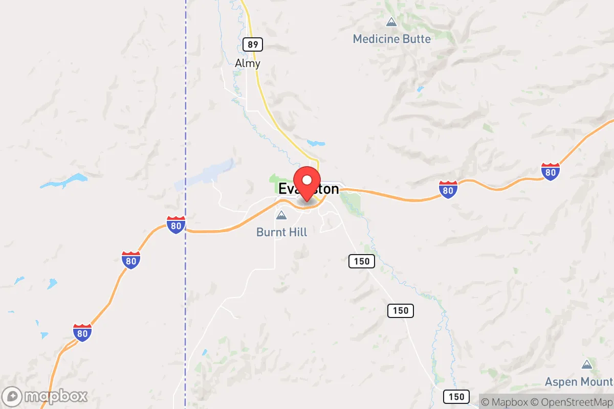
Evanston, Wyoming, sits in a strategic sweet spot that few relocation analysts fully appreciate: it is far enough from the major population centers of the Intermountain West to avoid the worst of cascading urban collapse, yet close enough to critical transportation corridors and natural resources to sustain a post-disruption household. Located just off Interstate 80 in the southwest corner of the state, Evanston offers a combination of geographic isolation, access to high-altitude water sources, and a low population density that makes it a serious contender for anyone thinking through long-term resilience. For the prepper or survivalist looking at the deteriorating national picture, this town of roughly 12,000 people presents a defensible, resource-rich base of operations—provided you understand both its strengths and its very real vulnerabilities.
Geographic position and natural advantages for long-term survival
Evanston’s location at the intersection of the Bear River and the Wasatch Range gives it a natural buffer against the chaos that would likely engulf larger cities in a crisis. The town sits at 6,800 feet elevation, which provides a significant defensive advantage: the surrounding mountains and high desert create natural chokepoints on the few roads leading in and out. To the west, the Wasatch Front—home to Salt Lake City and its 1.2 million people—is roughly 80 miles away, a distance that in a grid-down scenario would become a formidable barrier due to mountain passes and limited fuel availability. To the east, the Red Desert and the Great Divide Basin stretch for hundreds of miles of nearly empty high plains, making overland travel from the Front Range cities (Denver, Cheyenne) a multi-day ordeal. This isolation is Evanston’s primary strategic asset. The Bear River, which flows through the town, is one of the few major rivers in the region that originates in high-altitude snowpack and runs year-round, providing a reliable surface water source that does not depend on municipal infrastructure. The Uinta Mountains to the south hold some of the deepest snowpack in the lower 48, meaning that even in drought years, Evanston’s watershed is more resilient than most places in the arid West. For a relocator, this means you are not dependent on the Colorado River system or the over-allocated reservoirs that serve Las Vegas, Phoenix, and Los Angeles—a critical advantage as those systems face increasing strain.
Risks, exposures, and proximity to fallout-relevant landmarks
No location is without its downsides, and Evanston has several that a serious prepper must account for. The most obvious is its proximity to the Union Pacific mainline and Interstate 80, both of which run directly through town. In a national emergency, I-80 would become a primary evacuation and military logistics corridor, potentially drawing refugees, looters, or government convoys through the area. The transcontinental railroad also carries hazardous materials—including crude oil from the Bakken fields and various chemicals—and a derailment or deliberate attack could contaminate the Bear River watershed for miles downstream. Evanston is also roughly 50 miles from the Hill Air Force Base complex near Ogden, Utah, which houses the F-35 fleet and significant munitions storage. In a major conflict, that base would be a high-priority target, and while Evanston is outside the likely blast radius of a conventional strike, fallout patterns from a dirty bomb or a chemical weapons incident at the base could drift eastward depending on wind conditions. The town itself has no major industrial or military targets, which is a plus, but it sits within the 100-mile zone of several potential flashpoints. On the natural disaster front, the area is seismically active—the Wasatch Fault runs just west of the Utah border—and a major earthquake (magnitude 7.0 or greater) could disrupt I-80 and the railroad for weeks, effectively cutting Evanston off from supply chains. Wildfire risk is moderate but increasing with drought; the surrounding sagebrush and pinyon-juniper woodlands can burn hot and fast, though the town’s low-density layout and firebreaks from the river and irrigated fields provide some natural protection.
Practical resilience for a relocator: food, water, energy, and defensibility
For a household looking to become self-sufficient, Evanston offers a mix of promising and challenging conditions. Water is the strongest asset: the Bear River runs through town with a mean annual flow of over 600 cubic feet per second, and senior water rights in Wyoming are among the most secure in the West. A well-drilled into the alluvial aquifer near the river can produce potable water at depths of 50 to 150 feet, and the local water table is generally reliable. However, the growing season is short—only about 90 to 100 frost-free days—which limits what you can grow outdoors. Cold-hardy crops like potatoes, carrots, kale, and certain grains (oats, barley) do well, but forget about tomatoes or corn without a greenhouse. The soil is alkaline and rocky, so raised beds with imported topsoil are almost mandatory for serious gardening. For protein, the area supports mule deer, pronghorn, and elk hunting on public lands (the Uinta-Wasatch-Cache National Forest and the BLM lands south of town), and the Bear River has native cutthroat trout. Livestock is feasible if you have acreage—cattle and sheep ranching are the traditional economy—but winter feeding costs are high. Energy is a mixed picture: Evanston is in a coal and natural gas region, with the Bridger Coal Mine and the Jim Bridger Power Plant about 30 miles east, but those are grid-dependent. For off-grid power, solar is marginal at this latitude and elevation—winter days are short and snow cover reduces panel output—but small-scale wind turbines can work well in the consistent winds that blow through the Bear River Valley. Wood heating is viable if you have access to public lands for firewood collection, though the high desert lacks dense timber; you will need to plan for a mix of propane, wood, and solar. Defensibility is good for a small group: the town is compact, with the river forming a natural boundary on the north and the railroad grade providing a raised perimeter on the south. The surrounding terrain is open enough to provide long sightlines, and the few bridges over the Bear River are easily controlled. For a family or a small team, Evanston offers a defendable position with multiple escape routes into the Uintas or the Red Desert—but it is not a fortress, and a determined group with vehicles could still approach from multiple directions.
The overall strategic picture for Evanston is one of cautious optimism for the prepared relocator. It is not a bug-out location for the weekend warrior; it is a place where you can build a sustainable, long-term homestead if you are willing to invest in infrastructure—greenhouses, well pumps, solar-plus-wind hybrid systems, and a serious food storage program. The town’s small size and conservative culture (Uinta County voted +57 for Trump in 2020) mean that community trust and mutual aid are more viable here than in a coastal suburb, but you will still need to earn your place. The biggest strategic risk is not natural disaster or even fallout—it is the possibility that Evanston becomes a waypoint for refugees fleeing the Wasatch Front in a collapse scenario. If Salt Lake City empties, I-80 will become a river of desperate people, and Evanston’s location astride that corridor could turn from an asset into a liability. The countermeasure is to establish yourself as a producer, not a consumer—grow food, store water, and build relationships with neighbors before the crisis hits. For the conservative prepper who wants to be out of the blast zone but not so remote that logistics become impossible, Evanston sits in a narrow band of viability that few other towns in the Intermountain West can match. It is a place to bet on, but only if you come prepared to work.
* Values derived from national, state, county, city and local statistics and may differ in a specific area. Last updated: 2026-04-21T11:28:45.000Z
Narrative content on this page is AI-generated and may contain mistakes. Verify any details that matter before acting on them.
ReloMaps may earn a commission from affiliate links at no extra cost to you.