
Photo: Wikipedia
Strategic Assessment of Franklin, NH
Meaningful friction. Expect exposure to either population pressure, blast zones, or natural disaster risk. Consider buying a retreat property.
What does the Strategic Assessment tell us?
Our Strategic Assessment grades tactical survivability of an area. Major population centers, military targets, fallout zones, natural disasters, and border exposure all drive risk — lower exposure means a more defensible position in a crisis.
This is heavily inspired by Joel Skousen's Strategic Relocation book. Highly recommended you checkout the book ($)What does this tell us?
Our Strategic Assessment grades tactical survivability of an area. Major population centers, military targets, fallout zones, natural disasters, and border exposure all drive risk — lower exposure means a more defensible position in a crisis.
This is heavily inspired by Joel Skousen's Strategic Relocation book. Highly recommended you checkout the book ($)Strategic Pillars

Key Distances
Regional Safe Places
Below is our recommended "safe zones" in New Hampshire and the surrounding area based on our strategic heuristics. For most people, it's unrealistic to live in a “safe zone” full-time due to work, family or other personal reasons. They tend to be more rural. However, many of these areas are perfect for second homes and retreat properties that double as a vacation home or even a short-term rental.


Important Note: For informational purposes only. This does not mean nothing bad ever happens in the green zones. Please use common sense. This is based on public data and modeled with AI. We tried to take a conservative approach but mistakes happen. We update this regularly as new information becomes available.
Solar Generator Recommendations
Backup power matters more here than in safer locations. We've picked three solar generators across budgets and capacity tiers — start with the budget unit if you only need a few essentials, or step up if you want to run a fridge and HVAC for days at a time.

Jackery Portable Power Station Explorer 300
Budget OptionPower on the Go: Weighing only 11 lbs, it's convenient to set up and store with book-sized foldable solar panels

BLUETTI Portable Power Station AC180
Designed for both indoor and outdoor scenarios, AC180 is highly capable as it has a robost capacity and continuous output power.

EF ECOFLOW DELTA Pro Ultra Power Station
Upgraded PickEcoFlow DELTA Pro Ultra is a whole-home energy system designed to grow with your family. Integrated with the Smart Home Panel 2, it scales to meet your evolving energy needs — keeping your home powered, intelligent, and secure through every stage of life.
We earn a commission, at no additional cost to you.
Strategic Assessment Analysis
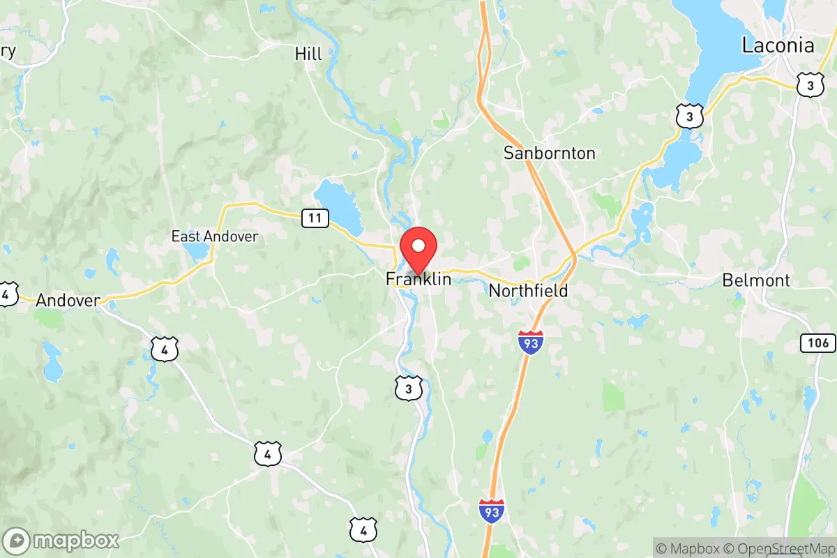
Franklin, New Hampshire, offers a compelling strategic position for those prioritizing resilience and self-sufficiency, sitting at the confluence of the Pemigewasset and Winnipesaukee Rivers in the Lakes Region. Its location roughly 20 miles north of Concord and 30 miles from the Massachusetts border provides a buffer from the immediate fallout of a major metropolitan collapse, while still being within a practical distance for supply runs or medical care in stable times. The city’s population hovers around 8,500, giving it a small-town feel with access to essential services, but its real value lies in the surrounding natural infrastructure and the relative isolation from high-density population centers that would become liabilities during widespread unrest.
Geographic position and natural advantages for long-term security
Franklin’s geography is its primary strategic asset. The city sits in a valley carved by the Merrimack River’s headwaters, with the surrounding terrain rising into the foothills of the White Mountains. This topography offers natural defensibility—elevated positions to the north and east provide observation points, while the river corridors create chokepoints that could be monitored or controlled. The area is part of the broader Lakes Region, meaning abundant freshwater sources beyond municipal supplies: the Winnipesaukee River flows through town, and nearby lakes like Winnisquam and Newfound offer backup water access. The region’s forest cover is dense, providing both cover and a long-term resource for timber, fuel, and game. For a relocator, this means you’re not boxed in by suburban sprawl; you have escape routes north into the White Mountain National Forest or east toward the Maine border, both sparsely populated zones that would remain viable retreat areas during a crisis.
Risks, exposures, and proximity to fallout-relevant landmarks
The primary risk for Franklin is its proximity to the Boston-Worcester-Manchester corridor, a high-density population zone that would be a epicenter for civil unrest, supply chain collapse, or mass casualty events. While Franklin is 90 miles from Boston, that distance is a double-edged sword: close enough to feel the ripple effects of a metropolitan collapse—refugee flows, resource competition, and potential violence—but far enough that the initial shockwave might not be immediate. The city is also within 50 miles of the Seabrook Nuclear Power Plant in New Hampshire, a potential target for sabotage or accident. A plume from Seabrook could reach Franklin depending on wind patterns, though the prevailing winds typically carry eastward toward the coast. Additionally, the nearby Concord area (20 miles south) hosts state government infrastructure, which could become a target for unrest or a focal point for martial law enforcement. The I-93 corridor, running north-south through the region, is a primary evacuation route that could become clogged or dangerous during a crisis. For a prepper, these factors mean you need a plan for self-sufficiency that doesn’t rely on road access for at least 30 days, and you should avoid properties directly in the river valley flood zones, which are vulnerable to both natural disasters and being cut off by bridge failures.
Practical resilience for a relocator: food, water, energy, and defensibility
Franklin’s practical resilience is strong for a small city, but requires active preparation. The city’s water supply comes from the Merrimack River watershed, but municipal treatment plants are vulnerable to power outages or contamination events. A prepper should secure a private well on a property with a hand pump or solar-powered backup, or have a plan to draw from the Winnipesaukee River with a filtration system. The region’s growing season is short (roughly May to September), but the soil in the valley is fertile for small-scale agriculture, and local farms like Moulton Farm and Apple Hill Farm offer resources for seed stock and livestock. For energy, the area is served by Eversource, but grid reliability is moderate—winter ice storms can knock out power for days. Solar panels with battery storage are a wise investment, and wood stoves are common for heating, given the abundant local firewood. Defensibility is mixed: Franklin’s downtown is compact and walkable, but the residential outskirts offer better standoff distance. Properties on dead-end roads or with natural barriers (ridges, rivers) are ideal. The local police force is small (about 15 officers), and during a major event, state police would be stretched thin. The community itself is a mix of longtime residents and newer arrivals, with a culture of self-reliance that aligns with prepper values—gun ownership is common, and the local sportsman’s clubs offer training and networking. However, the city’s proximity to the state capital means it could see National Guard movements or checkpoints during a declared emergency, so a low-profile approach is advisable.
Overall, Franklin presents a balanced strategic picture for the conservative-minded relocator seeking a buffer from urban collapse without complete isolation. Its natural advantages—water, terrain, forest cover—are genuine assets, but the risks from the Boston corridor and Seabrook are real and require mitigation through property selection and preparation. The city is not a hardened bunker location; it’s a practical base for those willing to invest in self-sufficiency while maintaining access to regional resources. For a single individual or family, the key is to secure a property with private water, off-grid energy capability, and defensible access, then integrate into the local network of like-minded residents. Franklin won’t save you from a direct nuclear event or a full societal breakdown, but it offers a fighting chance in the more likely scenarios of civil unrest, supply chain disruptions, or regional disasters. The smart move is to treat it as a staging ground—not a final redoubt—with a plan to move deeper into the White Mountains if conditions deteriorate further.
* Values derived from national, state, county, city and local statistics and may differ in a specific area. Last updated: 2026-04-19T09:38:14.000Z
Narrative content on this page is AI-generated and may contain mistakes. Verify any details that matter before acting on them.
ReloMaps may earn a commission from affiliate links at no extra cost to you.