Photo: Wikipedia
Strategic Assessment of Front Royal, VA
Meaningful friction. Expect exposure to either population pressure, blast zones, or natural disaster risk. Consider buying a retreat property.
What does the Strategic Assessment tell us?
Our Strategic Assessment grades tactical survivability of an area. Major population centers, military targets, fallout zones, natural disasters, and border exposure all drive risk — lower exposure means a more defensible position in a crisis.
This is heavily inspired by Joel Skousen's Strategic Relocation book. Highly recommended you checkout the book ($)What does this tell us?
Our Strategic Assessment grades tactical survivability of an area. Major population centers, military targets, fallout zones, natural disasters, and border exposure all drive risk — lower exposure means a more defensible position in a crisis.
This is heavily inspired by Joel Skousen's Strategic Relocation book. Highly recommended you checkout the book ($)Strategic Pillars

Key Distances
Regional Safe Places
Below is our recommended "safe zones" in Virginia and the surrounding area based on our strategic heuristics. For most people, it's unrealistic to live in a “safe zone” full-time due to work, family or other personal reasons. They tend to be more rural. However, many of these areas are perfect for second homes and retreat properties that double as a vacation home or even a short-term rental.


Important Note: For informational purposes only. This does not mean nothing bad ever happens in the green zones. Please use common sense. This is based on public data and modeled with AI. We tried to take a conservative approach but mistakes happen. We update this regularly as new information becomes available.
Solar Generator Recommendations
Backup power matters more here than in safer locations. We've picked three solar generators across budgets and capacity tiers — start with the budget unit if you only need a few essentials, or step up if you want to run a fridge and HVAC for days at a time.

Jackery Portable Power Station Explorer 300
Budget OptionPower on the Go: Weighing only 11 lbs, it's convenient to set up and store with book-sized foldable solar panels

BLUETTI Portable Power Station AC180
Designed for both indoor and outdoor scenarios, AC180 is highly capable as it has a robost capacity and continuous output power.

EF ECOFLOW DELTA Pro Ultra Power Station
Upgraded PickEcoFlow DELTA Pro Ultra is a whole-home energy system designed to grow with your family. Integrated with the Smart Home Panel 2, it scales to meet your evolving energy needs — keeping your home powered, intelligent, and secure through every stage of life.
We earn a commission, at no additional cost to you.
Strategic Assessment Analysis
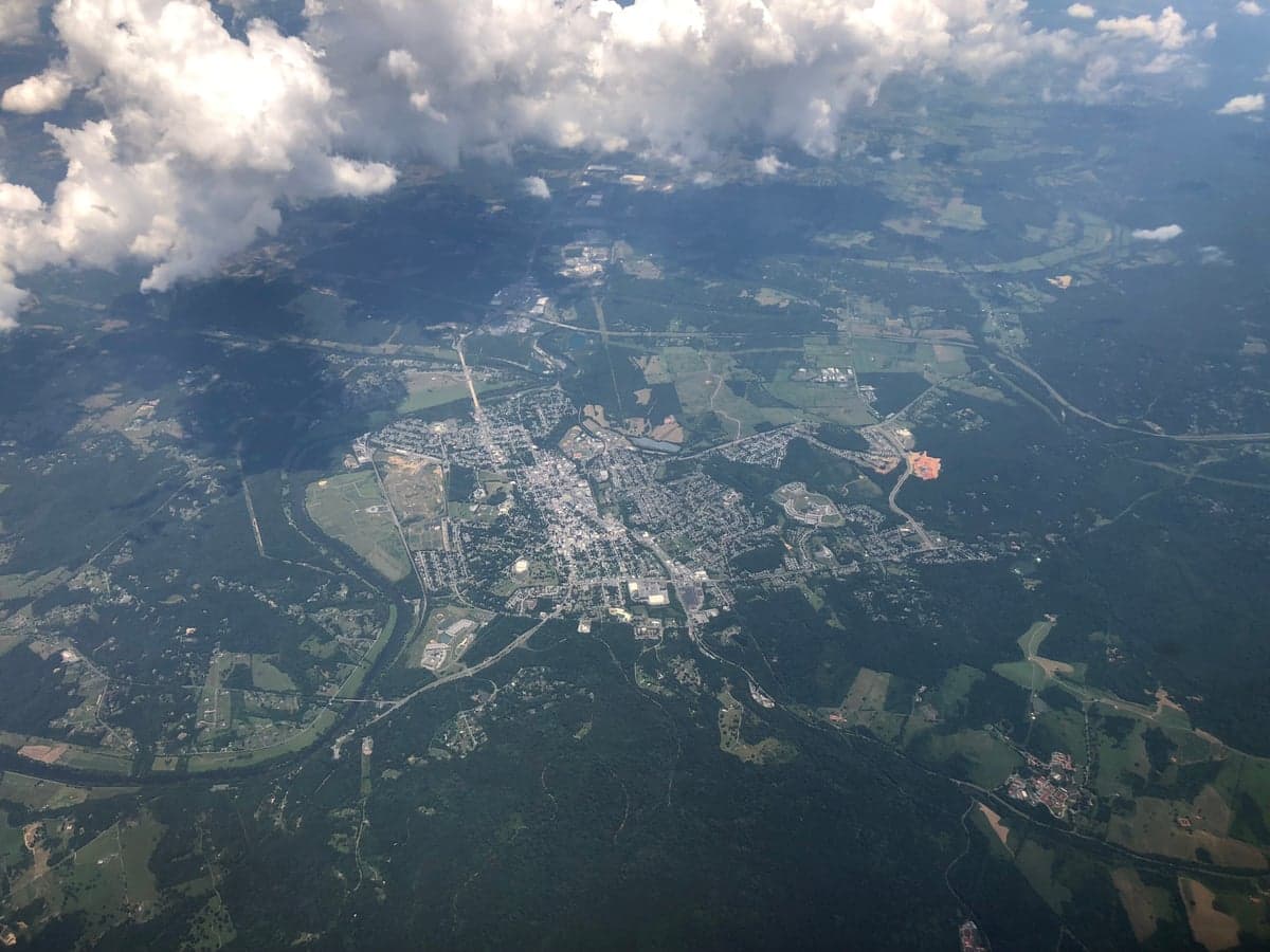
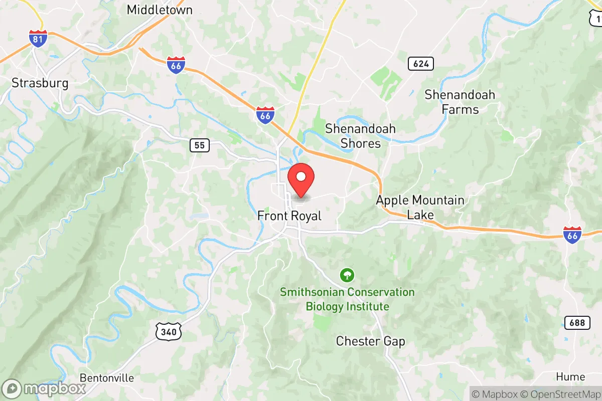
Front Royal, Virginia, occupies a strategic position that balances proximity to critical infrastructure with the natural buffers needed for long-term resilience. Nestled at the northern entrance of the Shenandoah Valley, this town of roughly 15,000 offers a rare combination: it sits just 70 miles from the Washington D.C. metro area—close enough to monitor the pulse of national events—yet is shielded by the Blue Ridge Mountains and the Shenandoah National Park. For a relocator with a prepper mindset, this isn't just a pretty landscape; it's a defensible chokepoint with multiple egress routes, a robust local food system, and a community that still values self-reliance over government dependency. The key question is whether the area's advantages outweigh its exposure to the fallout of a collapsing federal hub.
Geographic position and natural advantages for long-term security
Front Royal's location at the confluence of the Shenandoah River and the South Fork gives it a natural water advantage that most suburban sprawl zones lack. The town is the gateway to Skyline Drive and the Appalachian Trail, meaning you have immediate access to hundreds of thousands of acres of public land for hunting, foraging, and retreat if needed. The surrounding Warren County is a patchwork of limestone karst, forested ridges, and agricultural bottomland—terrain that makes large-scale military or mob movement difficult without using the few paved corridors. From a defensive standpoint, the area controls the northern entrance to the Shenandoah Valley, a historic invasion route. If you need to bug out, you have I-66 east toward the chaos or I-81 south toward deeper rural Virginia and Tennessee. But the real play here is that Front Royal sits on the eastern edge of the Valley, meaning you can retreat west into the mountains or south into less populated counties like Page or Shenandoah within 30 minutes. The town itself is a rail and highway hub, which is a double-edged sword—it gives you supply access but also makes it a potential target for infrastructure disruption.
Risks, exposures, and proximity to fallout-relevant landmarks
The single biggest risk for Front Royal is its proximity to the D.C. metroplex. At 70 miles from the Capitol, you are within the blast and electromagnetic pulse (EMP) radius of a high-yield nuclear detonation over the National Mall. An airburst of 300 kilotons would produce a thermal pulse and overpressure that could cause structural damage and fires as far as Front Royal, depending on wind direction. More realistically, the town lies directly under the flight paths for Andrews Air Force Base and Dulles International Airport, making it a potential secondary target or a zone for falling debris from intercepted missiles. The nearby Blue Ridge Tunnel and I-66 corridor are critical transportation links that would be jammed instantly during a crisis. Additionally, the Front Royal area hosts a major FBI training facility (Quantico is 40 miles east) and the Army's Fort Belvoir is within 60 miles—both are high-value targets. On the ground, the town's reliance on the Shenandoah River for water means contamination from upstream industrial sites or a chemical spill at the nearby I-81 trucking corridor could cut off your supply. The risk profile is moderate-to-high: you are not in a blast zone, but you are in the "fallout fringe" where panic, refugees, and supply chain collapse will hit first.
Practical resilience for a relocator: food, water, energy, and defensibility
For a prepper looking to establish a sustainable homestead, Front Royal offers genuine advantages. The Shenandoah Valley is one of the most productive agricultural regions in the Mid-Atlantic, with Warren County hosting dozens of small farms, orchards, and livestock operations. You can source grass-fed beef, pastured poultry, and heirloom vegetables within a 15-minute drive of downtown, and the local farmers' market operates year-round. Water is abundant: the Shenandoah River and its tributaries provide surface water, and the limestone geology means many properties have viable well water at depths of 100-300 feet. The area's growing season runs from April to October, allowing for serious gardening and food preservation. Energy resilience is mixed—the local electric grid is served by Dominion Energy and is prone to outages during winter storms and summer thunderstorms. However, the mountainous terrain makes solar viable, and many rural properties already have propane tanks and wood-burning stoves. Defensibility is where Front Royal shines: the town is surrounded by ridges that create natural observation points and chokepoints. The Shenandoah National Park to the east provides a nearly impassable barrier for vehicles, while the Massanutten Mountain range to the west creates a funnel effect for anyone approaching from the valley floor. If you secure a property on the western side of town, you have a clear line of sight to the main approaches and can retreat into the George Washington National Forest. The local gun culture is strong—Warren County has a high rate of firearm ownership and multiple shooting ranges—so you won't stand out as a prepper. The downside is that the town itself has a growing drug problem (opioids and meth), which means you need to secure your property against desperate locals, not just external threats.
The overall strategic picture for Front Royal is one of calculated risk. You are trading proximity to the federal leviathan for a defensible position with abundant natural resources. If you believe the country is heading toward a period of civil unrest, economic collapse, or a major conflict, Front Royal gives you a base from which you can monitor events in D.C. while having a viable retreat into the mountains. The town's infrastructure is fragile—one bridge closure on I-66 or a rail disruption could isolate it—but that isolation is also its strength. For a single individual or a family with a prepper mindset, Front Royal offers a realistic balance: close enough to the action to know what's happening, far enough to survive the initial shock, and embedded in a landscape that rewards self-sufficiency. The key is to avoid the subdivisions near the town center and instead secure land on the western slopes or in the southern part of the county. If you can handle the summer humidity and the occasional black bear, this is one of the better strategic bets on the East Coast for those who want to be prepared without going full off-grid in the middle of nowhere.
* Values derived from national, state, county, city and local statistics and may differ in a specific area. Last updated: 2026-04-21T11:45:23.000Z
Narrative content on this page is AI-generated and may contain mistakes. Verify any details that matter before acting on them.
ReloMaps may earn a commission from affiliate links at no extra cost to you.