Photo: Wikipedia
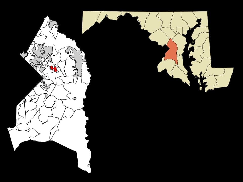
Strategic Assessment of Glenarden, MD
Multiple tactical vulnerabilities. Population density, target proximity, or disaster risk are likely compounding. A retreat property and exit planning is required.
What does the Strategic Assessment tell us?
Our Strategic Assessment grades tactical survivability of an area. Major population centers, military targets, fallout zones, natural disasters, and border exposure all drive risk — lower exposure means a more defensible position in a crisis.
This is heavily inspired by Joel Skousen's Strategic Relocation book. Highly recommended you checkout the book ($)What does this tell us?
Our Strategic Assessment grades tactical survivability of an area. Major population centers, military targets, fallout zones, natural disasters, and border exposure all drive risk — lower exposure means a more defensible position in a crisis.
This is heavily inspired by Joel Skousen's Strategic Relocation book. Highly recommended you checkout the book ($)Strategic Pillars

Key Distances
Regional Safe Places
Below is our recommended "safe zones" in Maryland and the surrounding area based on our strategic heuristics. For most people, it's unrealistic to live in a “safe zone” full-time due to work, family or other personal reasons. They tend to be more rural. However, many of these areas are perfect for second homes and retreat properties that double as a vacation home or even a short-term rental.


Important Note: For informational purposes only. This does not mean nothing bad ever happens in the green zones. Please use common sense. This is based on public data and modeled with AI. We tried to take a conservative approach but mistakes happen. We update this regularly as new information becomes available.
Solar Generator Recommendations
Backup power matters more here than in safer locations. We've picked three solar generators across budgets and capacity tiers — start with the budget unit if you only need a few essentials, or step up if you want to run a fridge and HVAC for days at a time.

Jackery Portable Power Station Explorer 300
Budget OptionPower on the Go: Weighing only 11 lbs, it's convenient to set up and store with book-sized foldable solar panels

BLUETTI Portable Power Station AC180
Designed for both indoor and outdoor scenarios, AC180 is highly capable as it has a robost capacity and continuous output power.

EF ECOFLOW DELTA Pro Ultra Power Station
Upgraded PickEcoFlow DELTA Pro Ultra is a whole-home energy system designed to grow with your family. Integrated with the Smart Home Panel 2, it scales to meet your evolving energy needs — keeping your home powered, intelligent, and secure through every stage of life.
We earn a commission, at no additional cost to you.
Strategic Assessment Analysis
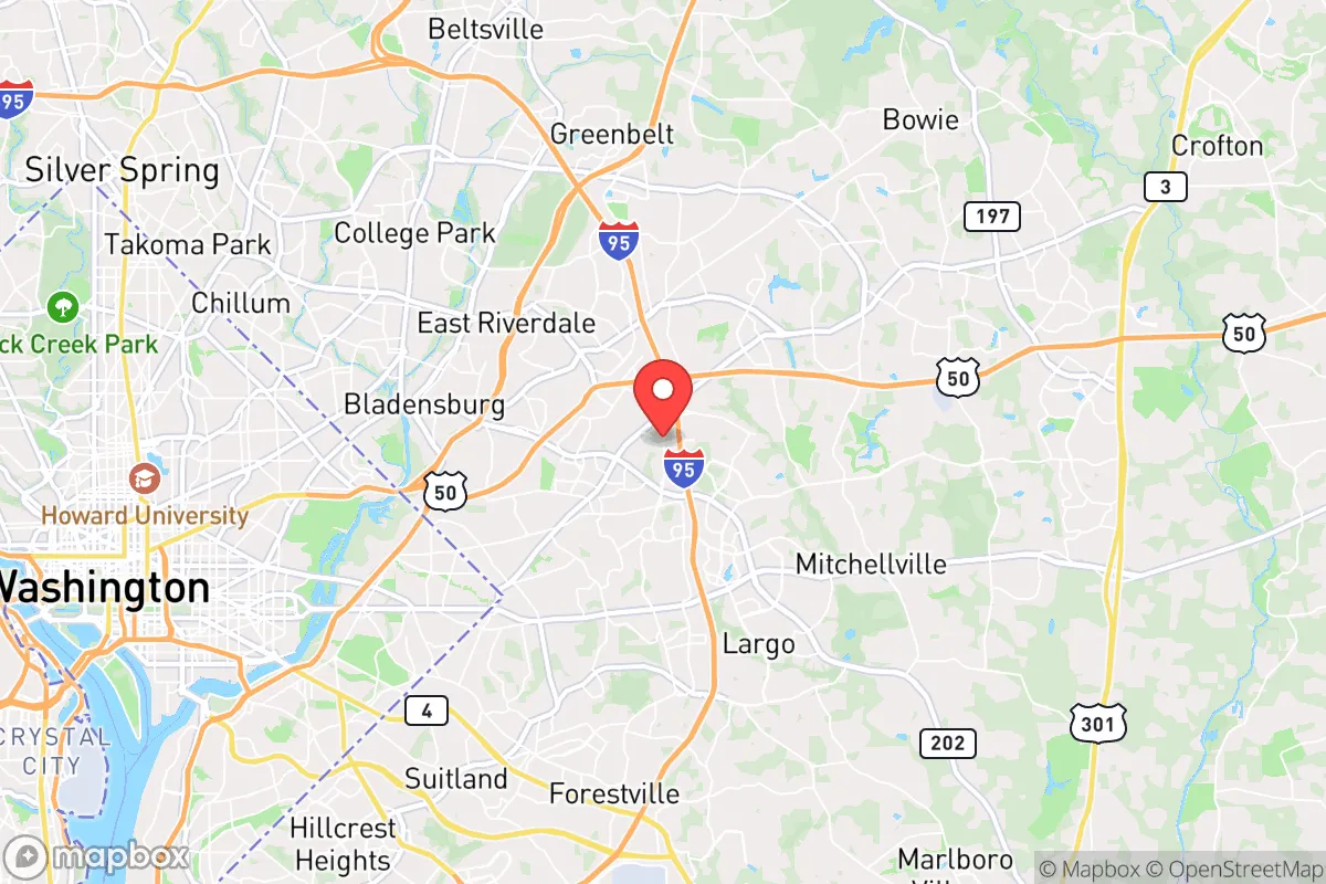
Glenarden, Maryland, sits in a precarious strategic position that demands a clear-eyed assessment. Located just east of Washington, D.C., and within the Capital Beltway, this Prince George’s County community offers proximity to federal infrastructure but carries severe liabilities for anyone prioritizing long-term resilience. For a conservative-leaning relocator—whether single or raising a family—the area’s advantages in transportation and access are overshadowed by its vulnerability to civil unrest, grid dependency, and proximity to high-value targets. This analysis strips away the real estate gloss and examines Glenarden as a potential base for preparedness-minded individuals.
Geographic position and natural advantages for a prepared household
Glenarden’s location at the intersection of the Capital Beltway (I-95/I-495) and Maryland Route 202 provides rapid egress to the broader Mid-Atlantic region, but that same connectivity makes it a chokepoint during any evacuation scenario. The area sits on the Atlantic Coastal Plain, with relatively flat terrain and sandy loam soils that drain poorly—meaning flooding is a recurring issue after heavy rains, particularly near the Western Branch of the Patuxent River. The natural environment offers limited defensible terrain; there are no significant hills, forests, or natural barriers to slow movement. The nearest substantial wooded area is the Patuxent Research Refuge, about 10 miles south, but that land is federally managed and not a viable retreat option. For a prepper, the lack of natural cover and the dense suburban grid of single-family homes and townhouses means any disruption—power outage, supply chain break, or civil unrest—would quickly expose residents to noise, light, and movement from neighbors. The area’s elevation averages around 100 feet above sea level, which offers no strategic vantage point. On the positive side, the proximity to the Patuxent River and several small lakes (like Lake Artemesia, about 5 miles north) provides potential water sources, though all are within developed areas and would require treatment. The climate is humid subtropical, with hot summers and mild winters—a mixed bag for off-grid living, as heat stress becomes a factor for anyone without reliable cooling.
Risks, exposures, and proximity to fallout-relevant landmarks
This is where Glenarden’s strategic picture turns grim. The city lies roughly 12 miles from the U.S. Capitol and 10 miles from Joint Base Andrews, making it a secondary impact zone for any event targeting federal or military assets. In a scenario involving a nuclear detonation or large-scale conventional attack on Washington, D.C., Glenarden would be within the moderate-to-severe fallout zone depending on wind patterns. The area is also within 5 miles of the Washington Gas transmission pipeline that runs through Prince George’s County—a critical infrastructure node that could become a secondary hazard during a major event. Civil unrest is a more immediate concern: Prince George’s County has a history of protests and civil disturbances, particularly along the Route 202 corridor and near the Capital Beltway. During the 2020 unrest, Glenarden saw roadblocks and looting in nearby commercial areas, and the local police response was hampered by the county’s broader resource strain. The proximity to D.C. means any national-level crisis—economic collapse, election disputes, or mass casualty events—will spill over into Glenarden within hours. The city’s population density of roughly 3,500 people per square mile means that a localized event (like a chemical spill on I-95 or a power substation failure) would affect thousands of residents simultaneously. The area is also in a FEMA-designated flood zone for the Patuxent River watershed, with several neighborhoods (particularly around Glenarden Parkway and Ardwick-Ardmore) experiencing repetitive flood losses. For a relocator, the risk profile is clear: Glenarden is a high-exposure, low-defensibility location that offers no buffer from the nation’s capital.
Practical resilience for a relocator: food, water, energy, and defensibility
For anyone serious about self-sufficiency, Glenarden presents significant hurdles. The city’s water supply comes from the Washington Suburban Sanitary Commission (WSSC), which draws from the Potomac River and the Patuxent reservoirs. In a grid-down scenario, WSSC’s system is vulnerable to both cyberattack and physical disruption—the treatment plants are known targets, and the distribution network has aging infrastructure with frequent main breaks. A household would need at least two weeks of stored water per person, plus a reliable filtration system (e.g., Berkey or Sawyer) for local sources like the Patuxent River or small ponds. Food storage is more feasible: Glenarden has several grocery stores (Safeway, Aldi, and a Walmart Supercenter within 3 miles), but these would be stripped within hours of any crisis. The area lacks significant agricultural land—the nearest working farms are in Upper Marlboro, about 8 miles southeast—so gardening space is limited to suburban backyards. For energy, the grid is served by Pepco, which has a mixed reliability record; outages during storms can last 24-48 hours. Solar panels are viable (the area gets about 200 sunny days per year), but homeowners’ associations in many Glenarden neighborhoods restrict visible installations. A generator is essential, but fuel supply would be a problem during a regional crisis—gas stations along Route 202 and Central Avenue would see long lines and likely run dry. Defensibility is the weakest link. The suburban layout—with interconnected streets, minimal fencing, and many cul-de-sacs—makes it difficult to secure a perimeter. Single-family homes on quarter-acre lots offer no standoff distance, and the dense tree canopy provides cover for anyone approaching. For a family, the best option is a home with a basement (common in the area) that can serve as a safe room, but that’s a reactive measure, not a proactive defense. The local police presence is moderate, but response times during a widespread event would be measured in hours, not minutes.
The overall strategic picture for Glenarden is one of calculated risk for a relocator with a prepper mindset. The area’s advantages—proximity to federal jobs, good schools (like Glenarden Woods Elementary), and a relatively affordable housing market compared to D.C. proper—are real but come with severe trade-offs. For a single individual or family willing to invest in robust storage, redundant power, and a solid evacuation plan, Glenarden could serve as a temporary base while building a more defensible retreat further out (e.g., in western Maryland or the Shenandoah Valley). But as a permanent location for long-term resilience, it falls short. The combination of high population density, proximity to high-value targets, and limited natural buffers makes it a location where preparedness is a constant, expensive effort rather than a sustainable lifestyle. If you’re looking for a place to ride out the coming instability, Glenarden is a waypoint, not a destination.
* Values derived from national, state, county, city and local statistics and may differ in a specific area. Last updated: 2026-04-19T07:41:47.000Z
Narrative content on this page is AI-generated and may contain mistakes. Verify any details that matter before acting on them.
ReloMaps may earn a commission from affiliate links at no extra cost to you.