
Photo: Wikipedia
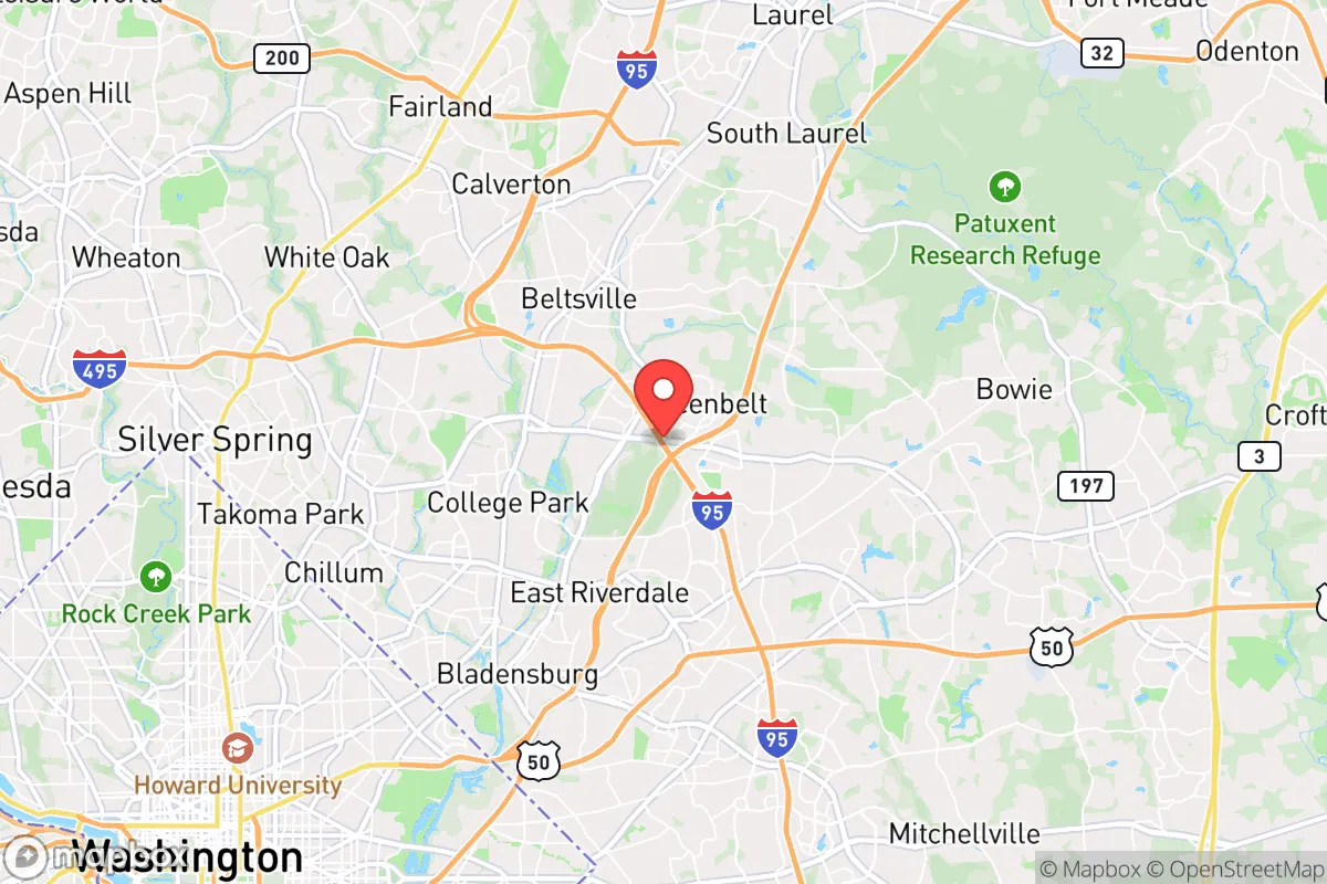
Strategic Assessment of Greenbelt, MD
Multiple tactical vulnerabilities. Population density, target proximity, or disaster risk are likely compounding. A retreat property and exit planning is required.
What does the Strategic Assessment tell us?
Our Strategic Assessment grades tactical survivability of an area. Major population centers, military targets, fallout zones, natural disasters, and border exposure all drive risk — lower exposure means a more defensible position in a crisis.
This is heavily inspired by Joel Skousen's Strategic Relocation book. Highly recommended you checkout the book ($)What does this tell us?
Our Strategic Assessment grades tactical survivability of an area. Major population centers, military targets, fallout zones, natural disasters, and border exposure all drive risk — lower exposure means a more defensible position in a crisis.
This is heavily inspired by Joel Skousen's Strategic Relocation book. Highly recommended you checkout the book ($)Strategic Pillars

Key Distances
Regional Safe Places
Below is our recommended "safe zones" in Maryland and the surrounding area based on our strategic heuristics. For most people, it's unrealistic to live in a “safe zone” full-time due to work, family or other personal reasons. They tend to be more rural. However, many of these areas are perfect for second homes and retreat properties that double as a vacation home or even a short-term rental.


Important Note: For informational purposes only. This does not mean nothing bad ever happens in the green zones. Please use common sense. This is based on public data and modeled with AI. We tried to take a conservative approach but mistakes happen. We update this regularly as new information becomes available.
Solar Generator Recommendations
Backup power matters more here than in safer locations. We've picked three solar generators across budgets and capacity tiers — start with the budget unit if you only need a few essentials, or step up if you want to run a fridge and HVAC for days at a time.

Jackery Portable Power Station Explorer 300
Budget OptionPower on the Go: Weighing only 11 lbs, it's convenient to set up and store with book-sized foldable solar panels

BLUETTI Portable Power Station AC180
Designed for both indoor and outdoor scenarios, AC180 is highly capable as it has a robost capacity and continuous output power.

EF ECOFLOW DELTA Pro Ultra Power Station
Upgraded PickEcoFlow DELTA Pro Ultra is a whole-home energy system designed to grow with your family. Integrated with the Smart Home Panel 2, it scales to meet your evolving energy needs — keeping your home powered, intelligent, and secure through every stage of life.
We earn a commission, at no additional cost to you.
Strategic Assessment Analysis
Greenbelt, Maryland, sits in a precarious strategic position that demands serious consideration for anyone prioritizing resilience and preparedness. While its location within the Washington, D.C. metropolitan area offers certain logistical advantages, it also places residents directly in the path of the highest-risk scenarios for civic unrest, mass casualty events, and infrastructure collapse. For a conservative-leaning relocator focused on self-reliance and long-term security, Greenbelt presents a mixed bag: proximity to federal power centers and major transit corridors is a double-edged sword, offering both potential escape routes and primary targets for disruption.
Geographic position and natural advantages for a prepared relocator
Greenbelt’s position in Prince George’s County, roughly 13 miles northeast of the U.S. Capitol, places it within the dense suburban ring of the National Capital Region. The area benefits from the Anacostia River watershed and proximity to the Patuxent River, which provide natural water sources—a critical asset for off-grid survival. The terrain is relatively flat but punctuated by forested patches, including the Greenbelt Park (1,176 acres of federally managed woodland) and the Beltsville Agricultural Research Center (6,500 acres of open fields and research plots). These green spaces offer limited but real opportunities for foraging, small-scale hunting, and temporary shelter if urban systems fail. The Baltimore-Washington Parkway and I-95/495 (Capital Beltway) intersect nearby, giving residents potential egress routes north toward Pennsylvania or west toward the Appalachian foothills. However, these same highways will become choke points during any evacuation scenario, as they are among the most congested corridors in the country. The area’s elevation is modest (around 160 feet above sea level), offering no natural defensive high ground, but the fall line between the Piedmont and Coastal Plain means slightly better drainage and less flood risk than low-lying D.C. neighborhoods.
Risks, exposures, and proximity to fallout-relevant landmarks
The single greatest vulnerability for Greenbelt is its proximity to high-value federal targets. The city lies within a 15-mile radius of the Pentagon, the White House, the U.S. Capitol, and multiple intelligence agencies (NSA at Fort Meade is 12 miles east). In any scenario involving a mass casualty event, electromagnetic pulse (EMP) attack, or large-scale civil unrest, these sites will be primary targets or flashpoints. The Joint Base Andrews (10 miles southeast) and Fort Meade (12 miles east) are military installations that could become staging areas or secondary targets. The Beltsville Agricultural Research Center itself, while a green space, houses high-containment labs (BSL-3) that could pose a biohazard risk if compromised. Additionally, the Washington Gas pipeline and multiple high-voltage transmission lines crisscross the area, creating infrastructure fragility during grid-down events. The Capital Beltway and Baltimore-Washington Parkway will become impassable within hours of any major incident, as seen during the 9/11 attacks and the 2020 unrest. For a prepper, the density of population (roughly 24,000 residents in Greenbelt proper, with over 900,000 in Prince George’s County) means competition for resources—food, water, fuel, and medical supplies—will be intense and immediate. The Greenbelt Metro Station (on the Green Line) is a transit hub that could funnel evacuees or, conversely, become a target for disruption.
Practical resilience for a relocator: food, water, energy, and defensibility
For a single individual or family committed to preparedness, Greenbelt offers a few practical assets but significant challenges. Water access is the strongest natural advantage: the Anacostia River and Indian Creek run through the area, and the Patuxent River is within a 15-minute drive. However, these waters are heavily polluted with urban runoff and industrial contaminants, requiring advanced filtration (reverse osmosis or distillation) for safe consumption. Food production is limited by the suburban lot sizes—most homes sit on quarter-acre plots or less. Community gardens exist (e.g., the Greenbelt Community Garden), but they are not secure for long-term subsistence. The Beltsville Agricultural Research Center is a potential source of seeds and agricultural knowledge, but it is federally controlled and likely to be locked down during a crisis. Energy resilience is hampered by the area’s reliance on the PJM Interconnection grid; solar panel installations are feasible but face shading from mature trees and HOA restrictions in some neighborhoods. Natural gas is widely available for heating, but pipelines are vulnerable to disruption. Defensibility is poor: Greenbelt is a typical suburban grid with multiple entry points, no natural barriers, and a police force (Prince George’s County Police) that will be overwhelmed in a widespread event. The Greenbelt Police Department has about 60 officers, but mutual aid agreements with D.C. and surrounding counties will be strained. For a relocator, the best defensive strategy is to have a bug-out location pre-established in a rural area (e.g., western Maryland or West Virginia) and a vehicle with a full tank of gas and a go-bag ready at all times. The MARC Camden Line train offers a rail egress option, but it is unreliable during disruptions.
The overall strategic picture for Greenbelt is one of high risk with limited reward for the serious prepper. Its location near the federal core makes it a likely epicenter of chaos during any national-level crisis, and the population density ensures that resources will be scarce and competition fierce. The natural water sources and green spaces are real assets, but they are insufficient to sustain a family long-term without extensive pre-positioning of supplies and a robust security plan. For a conservative relocator who values self-reliance and wants to avoid the worst of urban collapse, Greenbelt is best viewed as a temporary staging area—a place to live while working in the D.C. area, but with a clear exit strategy and a fully stocked retreat property elsewhere. If you are committed to staying, invest in underground water storage, a high-capacity filtration system, a solar generator, and a community network of like-minded neighbors. The Greenbelt Co-op Supermarket and local farmers’ markets are useful for daily life, but they will be empty within 48 hours of a major event. In short: Greenbelt is not a survivalist’s haven, but with meticulous planning and a low-profile approach, it can be a functional base for those who must remain in the region for work or family obligations. The key is to treat it as a high-risk, high-awareness environment—not a long-term sanctuary.
* Values derived from national, state, county, city and local statistics and may differ in a specific area. Last updated: 2026-04-22T01:16:10.000Z
Narrative content on this page is AI-generated and may contain mistakes. Verify any details that matter before acting on them.
ReloMaps may earn a commission from affiliate links at no extra cost to you.