Photo: Wikipedia
Strategic Assessment of Hermiston, OR
Workable tactical position. Some exposure to population density or targets, but generally defensible in a crisis.
What does the Strategic Assessment tell us?
Our Strategic Assessment grades tactical survivability of an area. Major population centers, military targets, fallout zones, natural disasters, and border exposure all drive risk — lower exposure means a more defensible position in a crisis.
This is heavily inspired by Joel Skousen's Strategic Relocation book. Highly recommended you checkout the book ($)What does this tell us?
Our Strategic Assessment grades tactical survivability of an area. Major population centers, military targets, fallout zones, natural disasters, and border exposure all drive risk — lower exposure means a more defensible position in a crisis.
This is heavily inspired by Joel Skousen's Strategic Relocation book. Highly recommended you checkout the book ($)Strategic Pillars

Key Distances
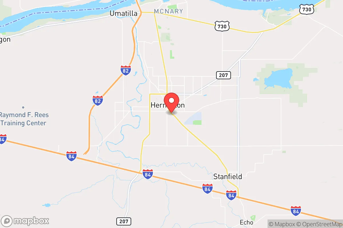
Regional Safe Places
Below is our recommended "safe zones" in Oregon and the surrounding area based on our strategic heuristics. For most people, it's unrealistic to live in a “safe zone” full-time due to work, family or other personal reasons. They tend to be more rural. However, many of these areas are perfect for second homes and retreat properties that double as a vacation home or even a short-term rental.


Important Note: For informational purposes only. This does not mean nothing bad ever happens in the green zones. Please use common sense. This is based on public data and modeled with AI. We tried to take a conservative approach but mistakes happen. We update this regularly as new information becomes available.
Solar Generator Recommendations
Backup power matters more here than in safer locations. We've picked three solar generators across budgets and capacity tiers — start with the budget unit if you only need a few essentials, or step up if you want to run a fridge and HVAC for days at a time.

Jackery Portable Power Station Explorer 300
Budget OptionPower on the Go: Weighing only 11 lbs, it's convenient to set up and store with book-sized foldable solar panels

BLUETTI Portable Power Station AC180
Designed for both indoor and outdoor scenarios, AC180 is highly capable as it has a robost capacity and continuous output power.

EF ECOFLOW DELTA Pro Ultra Power Station
Upgraded PickEcoFlow DELTA Pro Ultra is a whole-home energy system designed to grow with your family. Integrated with the Smart Home Panel 2, it scales to meet your evolving energy needs — keeping your home powered, intelligent, and secure through every stage of life.
We earn a commission, at no additional cost to you.
Strategic Assessment Analysis
Hermiston, Oregon, sits as a quiet but strategically significant outlier in the Pacific Northwest—a region often dominated by Portland and Seattle’s political and economic volatility. Its resilience stems from a combination of geographic isolation, a robust agricultural economy, and a community culture that leans heavily toward self-reliance and conservative values. For a relocator assessing long-term security, Hermiston offers a rare blend of food production capacity, water access, and distance from major population centers that could become flashpoints during unrest or disaster.
Geographic position and natural advantages for long-term security
Hermiston’s location in northeastern Oregon, roughly 30 miles from the Washington border, places it in a sweet spot: far enough from the I-5 corridor’s chaos but close enough to access critical infrastructure if needed. The city sits on the Columbia River Plateau, a semi-arid region that avoids the heavy snowpack and earthquake risks of the Cascades. The Columbia River itself is a major asset—it provides irrigation for the surrounding farmland and a potential water source for a prepared household. The area’s elevation (roughly 460 feet) and flat terrain reduce wildfire risk compared to forested parts of Oregon, though dry summers still demand caution. Hermiston’s position also puts it within a two-hour drive of the Tri-Cities (Richland, Kennewick, Pasco) in Washington, which offers medical and supply options without the density of a major metro. For a prepper, this means you’re not completely cut off, but you’re not living in a target-rich environment either.
Risks, exposures, and proximity to fallout-relevant landmarks
No location is without vulnerabilities, and Hermiston has a few that demand attention. The most obvious is the Hanford Nuclear Site, located just 30 miles northwest near Richland, Washington. Hanford is a decommissioned plutonium production facility with massive underground waste tanks—some of which have leaked. While a catastrophic release is unlikely, the proximity to a high-profile nuclear waste storage site is a real consideration for anyone mapping fallout zones. In the event of a major earthquake or terrorist attack on Hanford, prevailing winds could carry contamination southeast toward Hermiston. Additionally, the Umatilla Chemical Depot, about 15 miles south, once stored chemical weapons (now largely destroyed), but the site remains a potential target. On the plus side, Hermiston is far from Portland (180 miles), Seattle (230 miles), and Spokane (130 miles), meaning you’re unlikely to face the immediate civil unrest, supply chain collapse, or refugee flows that would hit those cities first. The nearest large population center is the Tri-Cities (roughly 300,000 people), which is manageable but still a risk if things go sideways. For a conservative relocator, the lack of dense urban populations nearby is a major strategic win—less competition for resources, fewer eyes on your property, and a lower chance of being caught in a mass casualty event.
Practical resilience for a relocator: food, water, energy, and defensibility
Hermiston’s agricultural base is its strongest card. The area is a major producer of potatoes, onions, corn, and hay, with the Hermiston Watermelon being a local icon. For a prepper, this means local food supply chains are robust, and you can source directly from farms or even grow your own on the fertile soil. The Columbia River provides abundant water, but you’ll need to secure a well or a river-access property—municipal water could be compromised in a grid-down scenario. Energy is a mixed bag: the region gets power from the Bonneville Dam system, which is reliable but vulnerable to cyberattack or physical sabotage. Solar is viable here—Hermiston averages over 200 sunny days per year—so a solar array with battery storage is a smart investment. Natural gas is available in town, but rural properties may rely on propane. Defensibility is decent: the flat terrain means you can’t hide in hills, but the low population density (roughly 18,000 in the city, 20,000 in the surrounding area) means you can find a property with good sightlines and limited neighbors. The local culture is heavily agricultural and conservative, with a strong hunting and firearms tradition—you’ll find like-minded people who value preparedness. The Umatilla County Sheriff’s Office is generally pro-Second Amendment, and Oregon’s recent gun laws (Measure 114) have faced legal challenges, but you should still check current regulations before moving. For daily life, Hermiston has a Walmart, a hospital (Good Shepherd Medical Center), and basic services, but you’ll need to stock up on specialized gear or medical supplies from larger cities.
The overall strategic picture for Hermiston is one of calculated trade-offs. You gain food security, water access, and distance from urban chaos, but you accept proximity to Hanford and a flat landscape that offers limited natural cover. For a conservative relocator looking to ride out societal instability, this is a solid B+ location—not a bug-out paradise, but a functional, low-profile base where you can build a resilient life. The key is to secure a property with a well, solar, and a defensible perimeter, and to integrate into the local community rather than stand out as an outsider. Hermiston won’t make you rich or famous, but it might keep you alive when the rest of the country is burning.
* Values derived from national, state, county, city and local statistics and may differ in a specific area. Last updated: 2026-05-29T16:32:23.000Z
Narrative content on this page is AI-generated and may contain mistakes. Verify any details that matter before acting on them.
ReloMaps may earn a commission from affiliate links at no extra cost to you.