
Photo: Wikipedia
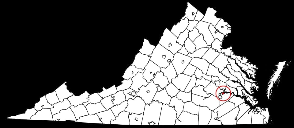
Strategic Assessment of Hopewell, VA
Meaningful friction. Expect exposure to either population pressure, blast zones, or natural disaster risk. Consider buying a retreat property.
What does the Strategic Assessment tell us?
Our Strategic Assessment grades tactical survivability of an area. Major population centers, military targets, fallout zones, natural disasters, and border exposure all drive risk — lower exposure means a more defensible position in a crisis.
This is heavily inspired by Joel Skousen's Strategic Relocation book. Highly recommended you checkout the book ($)What does this tell us?
Our Strategic Assessment grades tactical survivability of an area. Major population centers, military targets, fallout zones, natural disasters, and border exposure all drive risk — lower exposure means a more defensible position in a crisis.
This is heavily inspired by Joel Skousen's Strategic Relocation book. Highly recommended you checkout the book ($)Strategic Pillars

Key Distances
Regional Safe Places
Below is our recommended "safe zones" in Virginia and the surrounding area based on our strategic heuristics. For most people, it's unrealistic to live in a “safe zone” full-time due to work, family or other personal reasons. They tend to be more rural. However, many of these areas are perfect for second homes and retreat properties that double as a vacation home or even a short-term rental.


Important Note: For informational purposes only. This does not mean nothing bad ever happens in the green zones. Please use common sense. This is based on public data and modeled with AI. We tried to take a conservative approach but mistakes happen. We update this regularly as new information becomes available.
Solar Generator Recommendations
Backup power matters more here than in safer locations. We've picked three solar generators across budgets and capacity tiers — start with the budget unit if you only need a few essentials, or step up if you want to run a fridge and HVAC for days at a time.

Jackery Portable Power Station Explorer 300
Budget OptionPower on the Go: Weighing only 11 lbs, it's convenient to set up and store with book-sized foldable solar panels

BLUETTI Portable Power Station AC180
Designed for both indoor and outdoor scenarios, AC180 is highly capable as it has a robost capacity and continuous output power.

EF ECOFLOW DELTA Pro Ultra Power Station
Upgraded PickEcoFlow DELTA Pro Ultra is a whole-home energy system designed to grow with your family. Integrated with the Smart Home Panel 2, it scales to meet your evolving energy needs — keeping your home powered, intelligent, and secure through every stage of life.
We earn a commission, at no additional cost to you.
Strategic Assessment Analysis
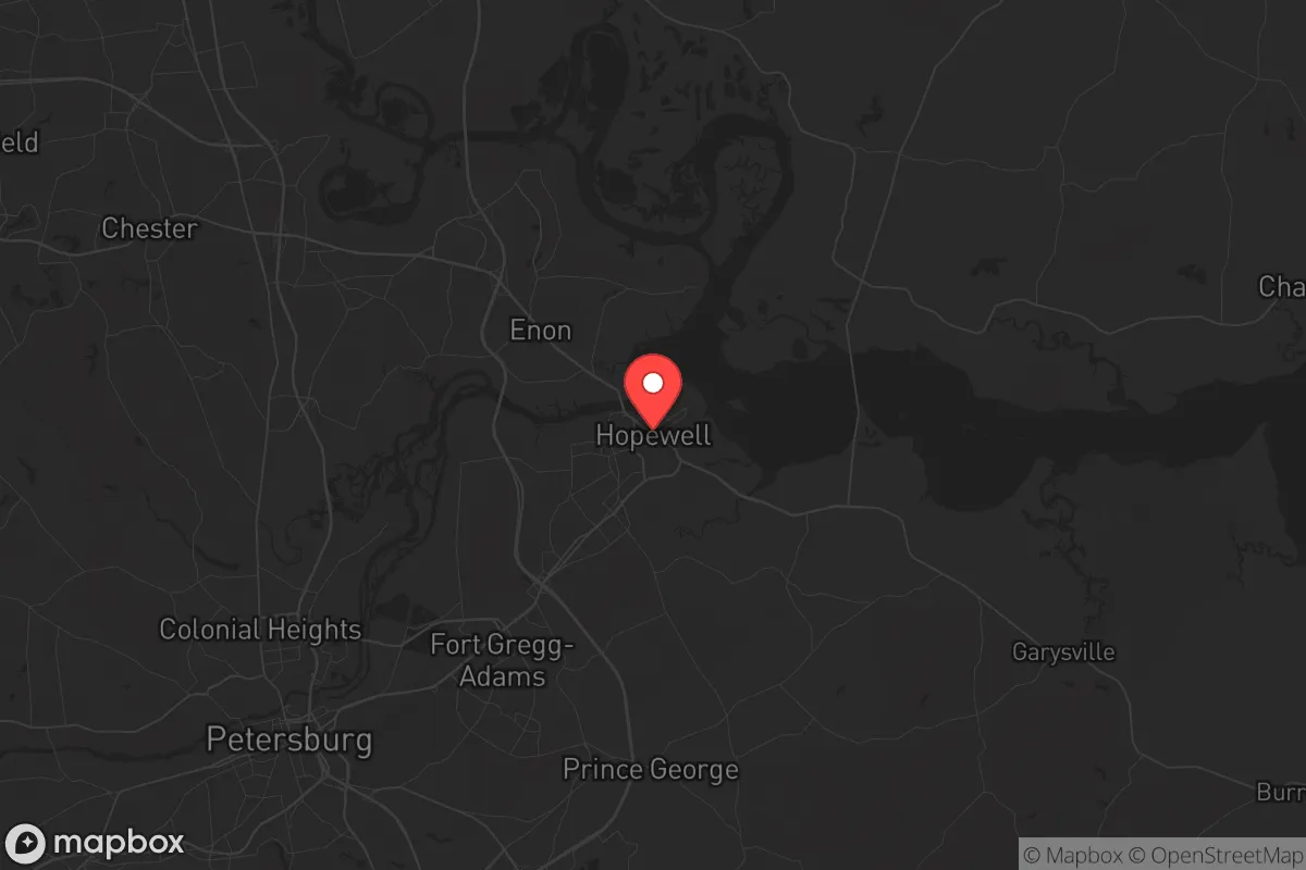
Hopewell, Virginia, sits at a strategic crossroads that offers a mixed bag for someone thinking long-term about resilience and self-reliance. Its location along the James and Appomattox Rivers, combined with its proximity to major transportation corridors like I-95 and Route 10, gives it both advantages and serious liabilities. For a prepper or survivalist looking at the mid-Atlantic, Hopewell is not a bunker location—it’s a buffer zone, close enough to Richmond and the Hampton Roads metro areas to feel the shockwaves of any major event, but far enough to offer a fighting chance if you’ve got a plan and a network.
Geographic position and natural advantages for long-term survival
Hopewell’s geography is defined by water. The confluence of the James and Appomattox Rivers provides a reliable surface water source, which is a non-negotiable for any long-term survival scenario. The surrounding terrain is mostly flat to gently rolling, with mixed hardwood forests that offer decent cover and potential for foraging, trapping, and small-scale timber use. The area sits in USDA Hardiness Zone 7b, meaning a longer growing season than much of the Northeast—you can get two crop cycles in if you know what you’re doing. The James River also historically served as a major trade and transport route, and while modern infrastructure has shifted to highways, the river remains a viable secondary route for moving goods or people if roads become impassable. The nearby Petersburg National Battlefield and Appomattox-Buckingham State Forest offer public land that, while not private, provides additional buffer space and resources if you’re willing to navigate the legalities. For a relocator, the key natural advantage here is water access and a temperate climate that doesn’t freeze you out for half the year.
Risks, exposures, and proximity to fallout-relevant landmarks
This is where Hopewell gets complicated. The city is less than 25 miles from Richmond, a major state capital and population center that would be a primary target for civil unrest, mass casualty events, or any coordinated attack on infrastructure. I-95, which runs just west of Hopewell, is a critical north-south artery that would become a chokepoint or a target in any major disruption. Closer to home, Hopewell itself hosts a massive chemical plant—the Honeywell facility and other industrial sites along the river—which means a single accident or sabotage event could render large portions of the area uninhabitable for weeks or months. The James River is also downstream from the North Anna Nuclear Generating Station, about 60 miles northwest. While that’s not a direct blast radius concern, a catastrophic failure there would put Hopewell in a downstream contamination zone. Additionally, Fort Gregg-Adams (formerly Fort Lee) is just south of the city, a major military logistics hub that could become a focal point for federal response or, conversely, a target in a conflict scenario. For a prepper, these are not deal-breakers, but they demand a layered plan: you need to know your evacuation routes, have a go-bag ready, and understand that Hopewell’s industrial and military proximity means you’re living in a potential secondary impact zone.
Practical resilience for a relocator: food, water, energy, and defensibility
On the practical side, Hopewell offers a mixed picture. Water is abundant from the rivers, but you’ll need filtration and treatment—industrial runoff and agricultural pollution are real concerns. The city’s municipal water system is aging, and in a grid-down scenario, you’d want a well or a reliable surface water collection setup. Food-wise, the surrounding region has decent agricultural potential, but Hopewell itself is urbanized; you’d need to secure land outside the city limits for serious gardening or livestock. The local farmers’ market and nearby farms in Prince George and Charles City counties offer some local food infrastructure, but don’t count on it in a crisis. Energy reliability is a concern: the grid here is tied to the same regional system that serves Richmond and Hampton Roads, so any widespread outage will hit Hopewell hard. Solar is viable given the region’s moderate cloud cover, but you’ll need battery storage to get through winter storms. Defensibility is the weakest point. Hopewell is flat, with no natural high ground, and its street grid is open and easily traversed. A rural property with a long driveway and tree cover would be far more defensible than anything in the city proper. For a relocator, the smart play is to buy land in the surrounding counties—Charles City, Prince George, or Surry—and use Hopewell as a supply hub, not a primary residence. The city’s hardware stores, medical facilities (John Randolph Medical Center), and big-box retailers make it a useful resupply point, but you don’t want to be living there when things go sideways.
The overall strategic picture for Hopewell is that of a high-risk, medium-reward location for a prepper or survivalist. It’s not a retreat—it’s a forward operating base. If you’re looking for a place to hunker down and ride out a long-term collapse, you’d be better off further west, toward the Blue Ridge or into the Shenandoah Valley. But if you need to stay within striking distance of the mid-Atlantic job market, have family obligations in the region, or want to maintain access to urban resources while keeping a foot in a more rural area, Hopewell can work—provided you’re honest about its vulnerabilities. The industrial hazards, proximity to Richmond and I-95, and lack of natural defensibility mean you need a solid plan, a network of like-minded people, and the willingness to bug out if the situation deteriorates. For a single individual or a family willing to put in the work—dig a well, install solar, stockpile supplies, and build relationships with local farmers and gun clubs—Hopewell offers a viable, if imperfect, base of operations. Just don’t mistake it for a safe haven. It’s a place to be prepared, not to be complacent.
* Values derived from national, state, county, city and local statistics and may differ in a specific area. Last updated: 2026-04-19T20:40:14.000Z
Narrative content on this page is AI-generated and may contain mistakes. Verify any details that matter before acting on them.
ReloMaps may earn a commission from affiliate links at no extra cost to you.