
Photo: Wikipedia
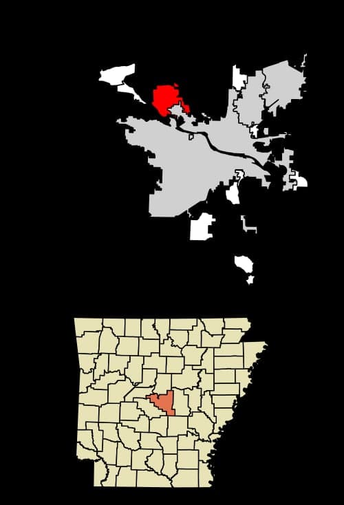
Strategic Assessment of Maumelle, AR
Workable tactical position. Some exposure to population density or targets, but generally defensible in a crisis.
What does the Strategic Assessment tell us?
Our Strategic Assessment grades tactical survivability of an area. Major population centers, military targets, fallout zones, natural disasters, and border exposure all drive risk — lower exposure means a more defensible position in a crisis.
This is heavily inspired by Joel Skousen's Strategic Relocation book. Highly recommended you checkout the book ($)What does this tell us?
Our Strategic Assessment grades tactical survivability of an area. Major population centers, military targets, fallout zones, natural disasters, and border exposure all drive risk — lower exposure means a more defensible position in a crisis.
This is heavily inspired by Joel Skousen's Strategic Relocation book. Highly recommended you checkout the book ($)Strategic Pillars

Key Distances
Regional Safe Places
Below is our recommended "safe zones" in Arkansas and the surrounding area based on our strategic heuristics. For most people, it's unrealistic to live in a “safe zone” full-time due to work, family or other personal reasons. They tend to be more rural. However, many of these areas are perfect for second homes and retreat properties that double as a vacation home or even a short-term rental.


Important Note: For informational purposes only. This does not mean nothing bad ever happens in the green zones. Please use common sense. This is based on public data and modeled with AI. We tried to take a conservative approach but mistakes happen. We update this regularly as new information becomes available.
Solar Generator Recommendations
Backup power matters more here than in safer locations. We've picked three solar generators across budgets and capacity tiers — start with the budget unit if you only need a few essentials, or step up if you want to run a fridge and HVAC for days at a time.

Jackery Portable Power Station Explorer 300
Budget OptionPower on the Go: Weighing only 11 lbs, it's convenient to set up and store with book-sized foldable solar panels

BLUETTI Portable Power Station AC180
Designed for both indoor and outdoor scenarios, AC180 is highly capable as it has a robost capacity and continuous output power.

EF ECOFLOW DELTA Pro Ultra Power Station
Upgraded PickEcoFlow DELTA Pro Ultra is a whole-home energy system designed to grow with your family. Integrated with the Smart Home Panel 2, it scales to meet your evolving energy needs — keeping your home powered, intelligent, and secure through every stage of life.
We earn a commission, at no additional cost to you.
Strategic Assessment Analysis
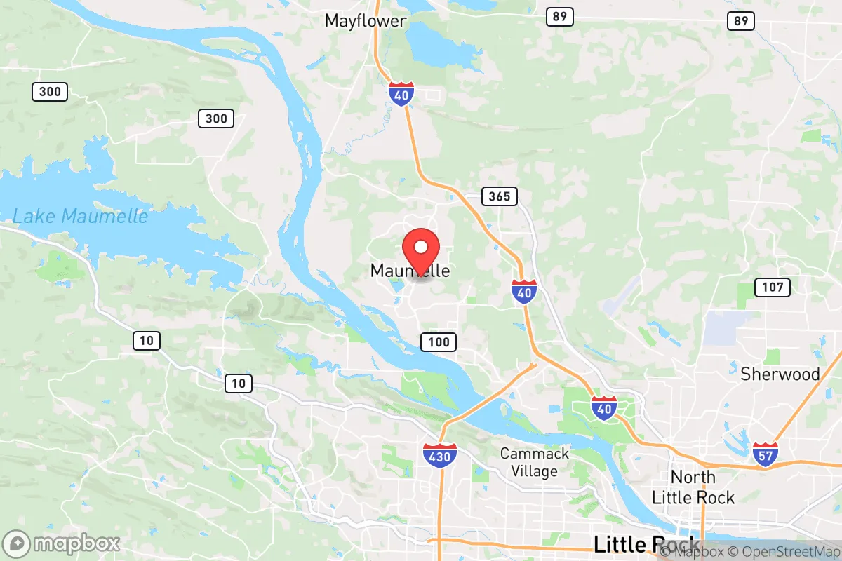
Maumelle, Arkansas, offers a strategic relocation option for those prioritizing resilience and preparedness, balancing proximity to essential infrastructure with a buffer from the most acute risks of urban collapse. Situated just northwest of Little Rock along the Arkansas River, this planned community of roughly 18,000 residents provides a defensible position with natural barriers, a lower population density than the capital, and access to key resources without being directly entangled in a major metropolitan grid. For a conservative-leaning individual or family concerned with civic unrest, mass casualty events, or systemic disruptions, Maumelle’s geographic and demographic profile presents a credible middle-ground—close enough to leverage urban supply chains, far enough to avoid being a primary target or choke point.
Geographic position and natural advantages for long-term security
Maumelle sits on the southern edge of the Arkansas River Valley, with the river forming a natural southern boundary and the foothills of the Ouachita Mountains rising to the north and west. This positioning offers several strategic benefits. The Arkansas River provides a reliable water source and a potential transportation corridor, while the surrounding hills and forests create natural chokepoints and defensible terrain. The city itself is laid out on a series of ridges and valleys, with limited entry points from the east and south—primarily via Interstate 40 and Highway 365. In a scenario requiring perimeter control or evacuation, these limited access routes can be monitored or blocked more easily than the sprawling suburban grids of Little Rock or North Little Rock. The area’s elevation, averaging around 300 feet above the river, reduces flood risk from the Arkansas River, though low-lying areas near the river remain vulnerable. The local climate is temperate, with four distinct seasons, which supports subsistence gardening and small-scale agriculture—a key consideration for long-term food security. The region’s average 50 inches of annual rainfall and fertile alluvial soils along the river make it viable for off-grid food production, unlike arid western states.
Risks, exposures, and proximity to fallout-relevant landmarks
Maumelle’s primary vulnerability stems from its proximity to Little Rock, roughly 12 miles southeast. Little Rock is a regional hub with a major interstate junction (I-30 and I-40), a federal reserve bank, the state capitol, and a significant military presence at Little Rock Air Force Base (located in Jacksonville, about 20 miles east). In a mass casualty event or civil unrest scenario, these assets could become targets or flashpoints. The air force base, home to the 19th Airlift Wing and C-130 operations, is a high-value military installation that could draw hostile attention or become a staging ground for federal responses. Additionally, the Arkansas River’s McClellan-Kerr Navigation System includes locks and dams near Maumelle, which could be strategic chokepoints for waterborne commerce or sabotage. The city itself has no major industrial or chemical facilities, but the nearby Port of Little Rock and several rail yards along the river present secondary risks for hazardous material spills or targeted disruptions. For a relocator, the key is that Maumelle is close enough to be affected by fallout from Little Rock—whether literal nuclear fallout or the social fallout of urban unrest—but far enough to provide a buffer. The natural terrain and limited road network mean that a determined group could defend the city’s perimeter, but residents should plan for potential isolation if I-40 or Highway 365 becomes impassable.
Practical resilience for a relocator: food, water, energy, and defensibility
For a prepper or survivalist, Maumelle offers a mixed bag of practical advantages and challenges. Water security is strong: the Arkansas River is a perennial source, and the city’s municipal water comes from the river via the Central Arkansas Water system. However, in a grid-down scenario, residents would need filtration or treatment capabilities, as the river carries agricultural runoff and industrial sediment. The local water table is high enough for shallow wells in many areas, but drilling permits and costs should be factored in. Food production is viable: the growing season runs from April to October, and the soil in the river valley is rich. Community gardens and backyard plots are common, and the nearby Pulaski County extension office offers resources for small-scale farming. For long-term storage, the climate’s humidity (averaging 70% year-round) requires careful pest and mold management—dehumidifiers and sealed containers are essential. Energy resilience is moderate: Entergy Arkansas provides grid power, but outages from storms (ice storms in winter, thunderstorms in spring) are frequent. Solar potential is decent, with about 200 sunny days per year, but tree cover in the hills can limit rooftop efficiency. Backup generators or off-grid solar with battery storage are recommended. Defensibility is a standout feature: Maumelle’s layout as a planned community with winding roads, cul-de-sacs, and greenbelts creates natural defensible zones. The city’s police department is well-funded relative to its size, and the local sheriff’s office (Pulaski County) has a reputation for professionalism. In a collapse scenario, the community’s homogeneity—predominantly white, middle-class, and conservative-leaning—could foster trust and cooperation, but it also means less diversity of skills. A relocator should prioritize building relationships with neighbors who have medical, mechanical, or agricultural expertise.
The overall strategic picture for Maumelle is one of calculated compromise. It is not a remote bunker site—it is a suburban enclave with a strong community identity, decent natural resources, and a manageable risk profile relative to larger cities. For a conservative individual or family seeking a base that balances access to modern infrastructure with the ability to weather short-to-medium-term disruptions, Maumelle warrants serious consideration. The key is to treat it as a staging ground: establish a self-sufficient household, build local networks, and maintain a vehicle capable of navigating the region’s rural roads for resupply or relocation if conditions deteriorate. The Arkansas River Valley offers a corridor of relative stability compared to the coasts or the Rust Belt, and Maumelle sits at a defensible node within that corridor. It is not a fortress, but it is a place where preparation and community can make the difference between surviving and thriving.
* Values derived from national, state, county, city and local statistics and may differ in a specific area. Last updated: 2026-04-30T04:22:05.000Z
Narrative content on this page is AI-generated and may contain mistakes. Verify any details that matter before acting on them.
ReloMaps may earn a commission from affiliate links at no extra cost to you.