
Photo: Wikipedia
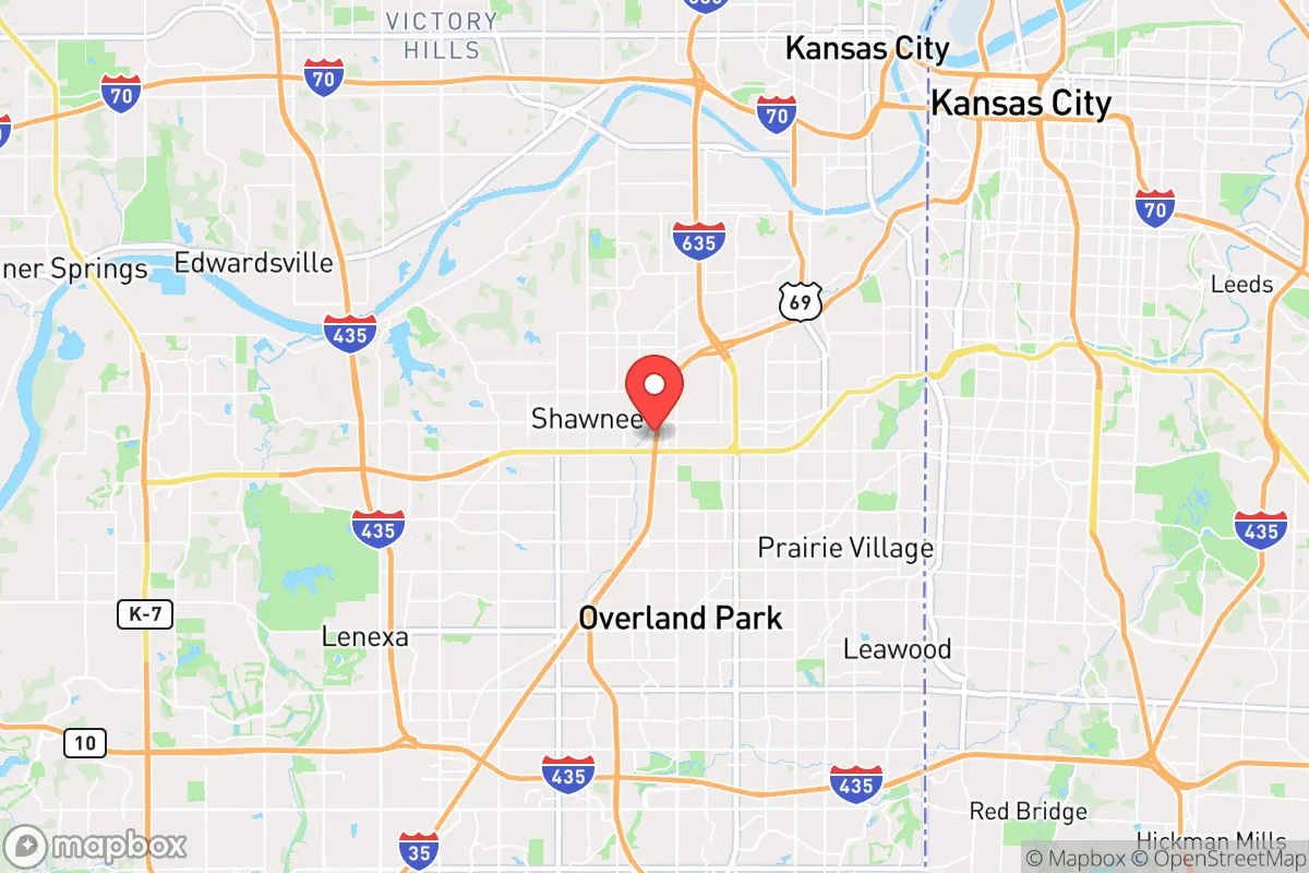
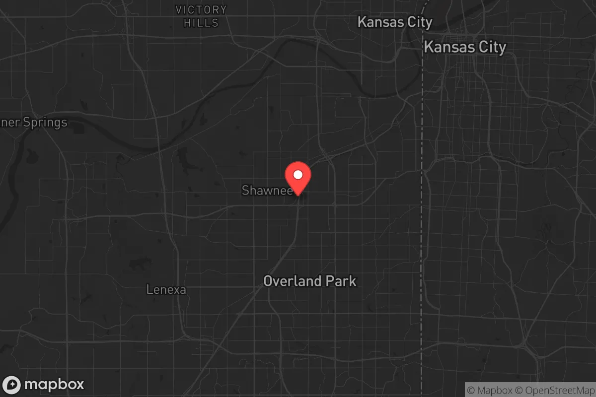
Strategic Assessment of Merriam, KS
Multiple tactical vulnerabilities. Population density, target proximity, or disaster risk are likely compounding. A retreat property and exit planning is required.
What does the Strategic Assessment tell us?
Our Strategic Assessment grades tactical survivability of an area. Major population centers, military targets, fallout zones, natural disasters, and border exposure all drive risk — lower exposure means a more defensible position in a crisis.
This is heavily inspired by Joel Skousen's Strategic Relocation book. Highly recommended you checkout the book ($)What does this tell us?
Our Strategic Assessment grades tactical survivability of an area. Major population centers, military targets, fallout zones, natural disasters, and border exposure all drive risk — lower exposure means a more defensible position in a crisis.
This is heavily inspired by Joel Skousen's Strategic Relocation book. Highly recommended you checkout the book ($)Strategic Pillars

Key Distances
Regional Safe Places
Below is our recommended "safe zones" in Kansas and the surrounding area based on our strategic heuristics. For most people, it's unrealistic to live in a “safe zone” full-time due to work, family or other personal reasons. They tend to be more rural. However, many of these areas are perfect for second homes and retreat properties that double as a vacation home or even a short-term rental.
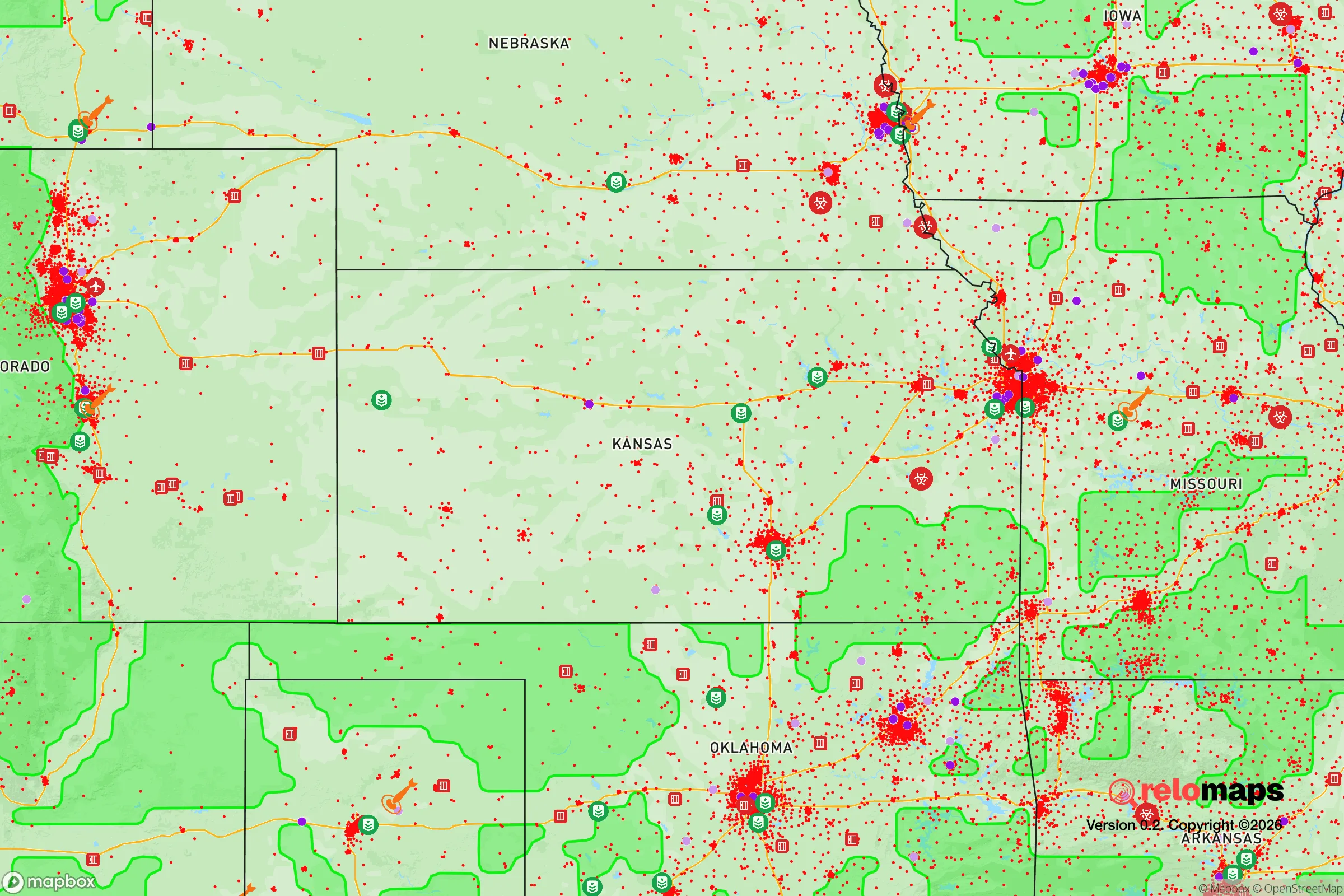
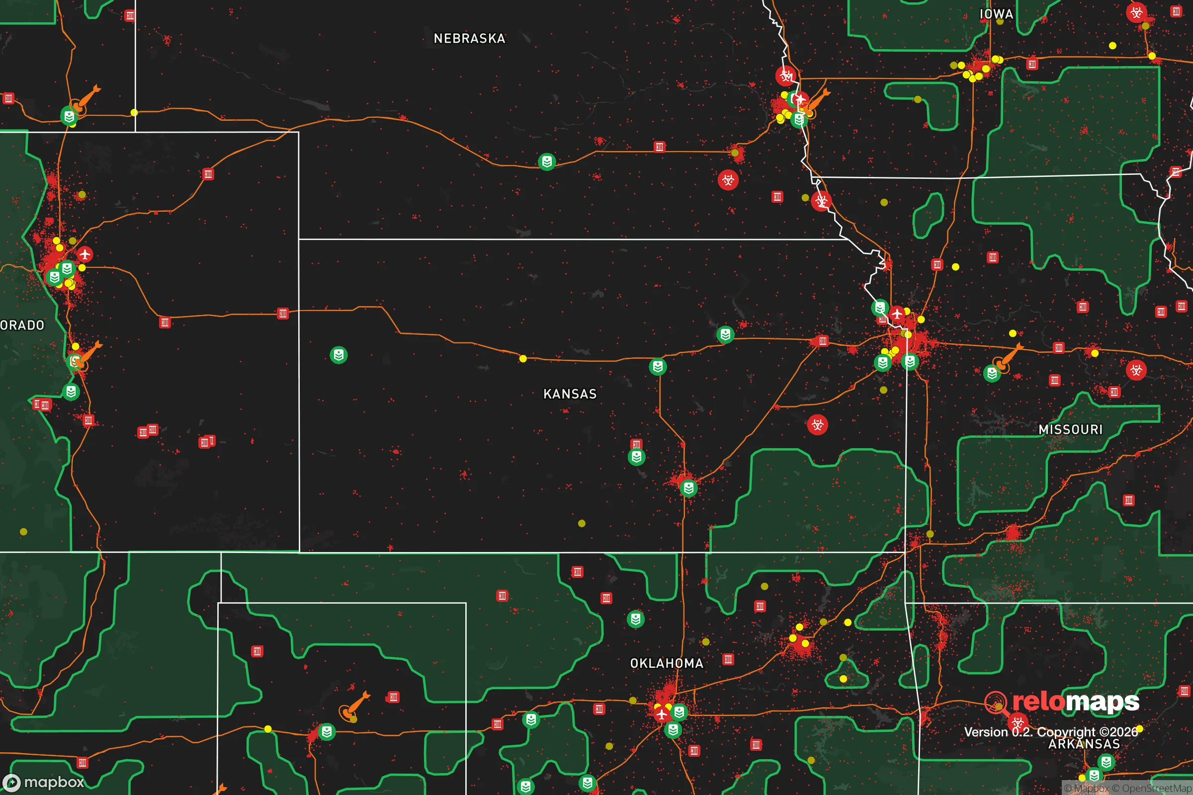
Important Note: For informational purposes only. This does not mean nothing bad ever happens in the green zones. Please use common sense. This is based on public data and modeled with AI. We tried to take a conservative approach but mistakes happen. We update this regularly as new information becomes available.
Solar Generator Recommendations
Backup power matters more here than in safer locations. We've picked three solar generators across budgets and capacity tiers — start with the budget unit if you only need a few essentials, or step up if you want to run a fridge and HVAC for days at a time.

Jackery Portable Power Station Explorer 300
Budget OptionPower on the Go: Weighing only 11 lbs, it's convenient to set up and store with book-sized foldable solar panels

BLUETTI Portable Power Station AC180
Designed for both indoor and outdoor scenarios, AC180 is highly capable as it has a robost capacity and continuous output power.

EF ECOFLOW DELTA Pro Ultra Power Station
Upgraded PickEcoFlow DELTA Pro Ultra is a whole-home energy system designed to grow with your family. Integrated with the Smart Home Panel 2, it scales to meet your evolving energy needs — keeping your home powered, intelligent, and secure through every stage of life.
We earn a commission, at no additional cost to you.
Strategic Assessment Analysis
Merriam, Kansas, sits in a precarious but potentially workable position for the strategic relocator. Its location within Johnson County places it just southwest of Kansas City, offering proximity to regional infrastructure while still being far enough from the urban core to avoid the worst of a sudden collapse. The area’s resilience is mixed: it benefits from a stable local economy and relatively low crime, but its density and proximity to major highways create vulnerabilities that a prepper must account for. For a conservative-minded individual or family looking to balance suburban convenience with a defensible fallback, Merriam demands a clear-eyed assessment of its strengths and weaknesses.
Geographic position and natural advantages for long-term stability
Merriam’s geographic position is defined by its location on the Kansas River floodplain, roughly 10 miles southwest of downtown Kansas City. This places it within the I-35 and I-635 corridors, which are critical for supply chains but also potential chokepoints during unrest. The area’s natural advantages are modest: the Kansas River provides a water source, though it is heavily industrialized and not immediately potable without treatment. The surrounding terrain is gently rolling prairie, offering decent visibility and limited natural cover. The climate is continental, with hot summers and cold winters, which means a relocator must plan for both extremes. The soil in Johnson County is fertile for small-scale gardening, but suburban development has reduced available land. For a prepper, the key natural advantage is the region’s relative distance from major fault lines and coastal storm zones, reducing risks from earthquakes and hurricanes. However, tornadoes are a real threat—Johnson County averages 12 tornado warnings per year, so a reinforced safe room or basement is non-negotiable.
Risks, exposures, and proximity to fallout-relevant landmarks
The most significant risk for Merriam is its proximity to Kansas City, a major population center and transportation hub. In a scenario of civil unrest or mass casualty events, Merriam would likely see spillover from urban violence, looting, and resource competition. The city is within 15 miles of several high-value targets: the Kansas City International Airport, the BNSF Railway intermodal facility, and the Truman Sports Complex (which could become a staging area for FEMA or military operations). Additionally, the nearby Wolf Creek Nuclear Generating Station (about 90 miles southwest) is a potential fallout risk if compromised, though prevailing winds typically carry fallout eastward. Merriam itself has no major industrial hazards, but the I-35 corridor is a primary evacuation route, meaning it could become clogged or targeted during a crisis. The Johnson County Sheriff’s Office is well-funded and professional, but in a widespread breakdown, suburban police forces are often overwhelmed quickly. For the strategic relocator, the takeaway is clear: Merriam is not a bug-out location but a staging area. You need a secondary retreat farther from the city, ideally 50+ miles into rural Kansas or Missouri.
Practical resilience for a relocator: food, water, energy, and defensibility
For daily life and short-term crisis survival, Merriam offers moderate practical resilience. The city’s water supply comes from the Kansas River via the Johnson County Water District, which has backup generators and redundant treatment plants. However, a prolonged power outage or contamination event would disrupt this supply within 48 hours. A relocator should store at least 14 days of water per person (56 gallons for a family of four) and have a Berkey or similar gravity filter for river water. Food access is decent: there are multiple grocery stores (Hy-Vee, Price Chopper) within a 5-minute drive, but these would empty within hours of a panic event. A 90-day supply of shelf-stable food is the minimum recommendation. Energy is a weak point—Merriam is served by Evergy, which has a history of outages during storms. Solar panels with battery storage are feasible, but homeowners associations (HOAs) in many Merriam neighborhoods restrict visible installations. A portable generator with 10+ gallons of stored fuel is more practical. Defensibility is the biggest challenge. Merriam’s suburban layout—cul-de-sacs, attached garages, and large windows—makes it hard to secure. A corner lot with a fenced backyard and reinforced doors is better than a mid-block house. The city’s police response time averages 6 minutes, but during a citywide event, that could stretch to hours or never come. For a family, the best approach is to harden a single room (safe room or basement) with supplies, communications gear, and a means of self-defense, while maintaining a low profile in the neighborhood.
The overall strategic picture for Merriam is one of calculated compromise. It offers a stable, low-crime base for normal life with good schools (Shawnee Mission School District) and a conservative-leaning local government (Johnson County voted +12 R in 2024). But for the prepper, it is not a destination—it is a waypoint. The area’s proximity to Kansas City creates unavoidable risks, and its suburban density limits long-term self-sufficiency. A sound strategy would be to use Merriam as a primary residence for work and community, while developing a rural retreat within a 2-hour drive (e.g., toward Emporia or the Flint Hills) for extended crises. Stockpile supplies here, build local networks with like-minded neighbors, and keep a bug-out vehicle ready. Merriam can work, but only if you treat it as a base of operations, not a fortress. The key is to stay prepared, stay quiet, and have an exit plan.
* Values derived from national, state, county, city and local statistics and may differ in a specific area. Last updated: 2026-04-30T06:49:56.000Z
Narrative content on this page is AI-generated and may contain mistakes. Verify any details that matter before acting on them.
ReloMaps may earn a commission from affiliate links at no extra cost to you.