
Photo: Wikipedia
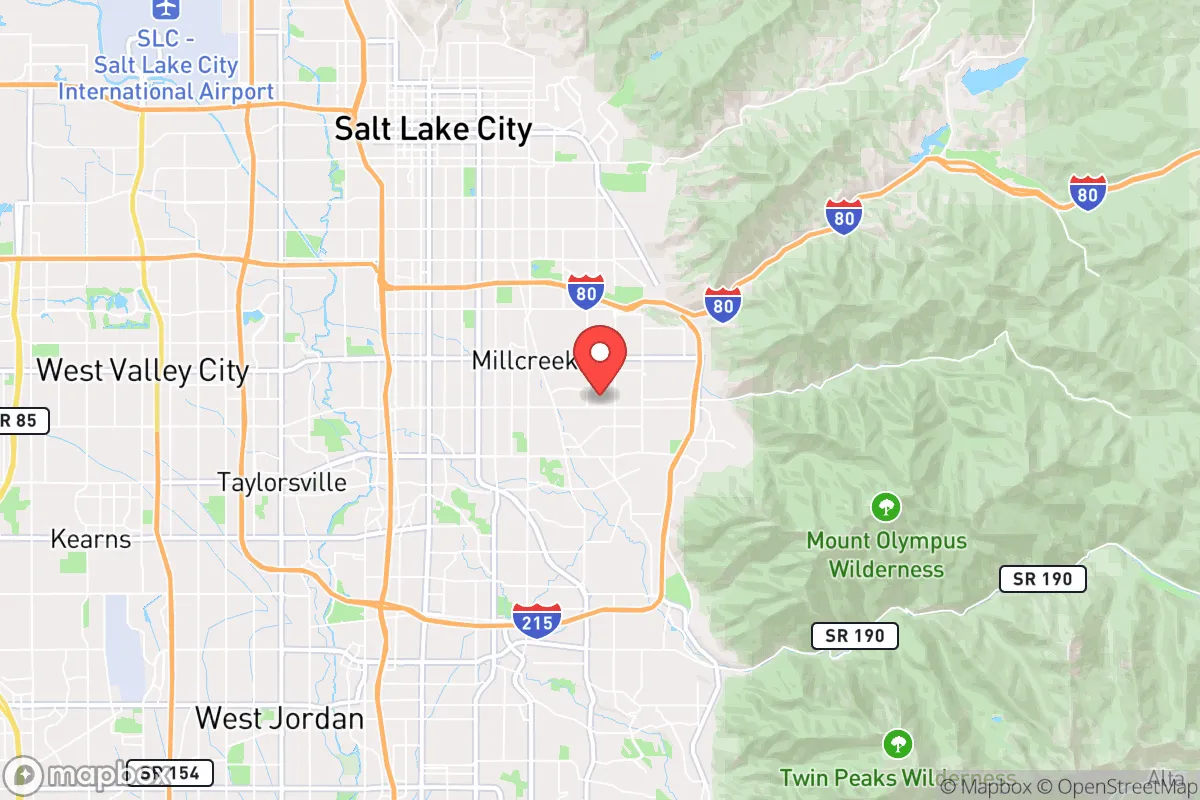
Strategic Assessment of Millcreek, UT
Workable tactical position. Some exposure to population density or targets, but generally defensible in a crisis.
What does the Strategic Assessment tell us?
Our Strategic Assessment grades tactical survivability of an area. Major population centers, military targets, fallout zones, natural disasters, and border exposure all drive risk — lower exposure means a more defensible position in a crisis.
This is heavily inspired by Joel Skousen's Strategic Relocation book. Highly recommended you checkout the book ($)What does this tell us?
Our Strategic Assessment grades tactical survivability of an area. Major population centers, military targets, fallout zones, natural disasters, and border exposure all drive risk — lower exposure means a more defensible position in a crisis.
This is heavily inspired by Joel Skousen's Strategic Relocation book. Highly recommended you checkout the book ($)Strategic Pillars

Key Distances
Regional Safe Places
Below is our recommended "safe zones" in Utah and the surrounding area based on our strategic heuristics. For most people, it's unrealistic to live in a “safe zone” full-time due to work, family or other personal reasons. They tend to be more rural. However, many of these areas are perfect for second homes and retreat properties that double as a vacation home or even a short-term rental.


Important Note: For informational purposes only. This does not mean nothing bad ever happens in the green zones. Please use common sense. This is based on public data and modeled with AI. We tried to take a conservative approach but mistakes happen. We update this regularly as new information becomes available.
Solar Generator Recommendations
Backup power matters more here than in safer locations. We've picked three solar generators across budgets and capacity tiers — start with the budget unit if you only need a few essentials, or step up if you want to run a fridge and HVAC for days at a time.

Jackery Portable Power Station Explorer 300
Budget OptionPower on the Go: Weighing only 11 lbs, it's convenient to set up and store with book-sized foldable solar panels

BLUETTI Portable Power Station AC180
Designed for both indoor and outdoor scenarios, AC180 is highly capable as it has a robost capacity and continuous output power.

EF ECOFLOW DELTA Pro Ultra Power Station
Upgraded PickEcoFlow DELTA Pro Ultra is a whole-home energy system designed to grow with your family. Integrated with the Smart Home Panel 2, it scales to meet your evolving energy needs — keeping your home powered, intelligent, and secure through every stage of life.
We earn a commission, at no additional cost to you.
Strategic Assessment Analysis
Millcreek, Utah, offers a surprisingly strong strategic position for those prioritizing resilience and preparedness, combining the resource access of a mid-sized city with the natural buffers of the Wasatch Front. Its location in a narrow valley corridor provides both advantages and distinct vulnerabilities that a serious relocator must weigh. While not a remote bunker, Millcreek’s proximity to critical infrastructure, water sources, and defensible terrain makes it a viable base for those who want to be near essential supplies without being trapped in a dense urban core. The key is understanding that this area’s resilience depends entirely on how well you can leverage its geography and mitigate its exposure to the risks inherent in any population center along the Wasatch Front.
Geographic position and natural advantages for long-term security
Millcreek sits at the mouth of Millcreek Canyon, a major drainage of the Wasatch Range, giving residents immediate access to high-elevation terrain, forest cover, and multiple escape routes into the Uinta-Wasatch-Cache National Forest. This canyon system provides a natural redoubt: a single paved road (Wasatch Boulevard/State Route 190) leads into the canyon, but numerous hiking and game trails offer secondary egress for those who know the land. The elevation gain from the valley floor (4,300 feet) to the canyon peaks (over 9,000 feet) creates a significant tactical advantage for observation and defense. Water is a critical asset here—Millcreek itself is a perennial stream fed by mountain snowmelt, and the nearby Parleys Creek and Big Cottonwood Creek systems provide redundant water sources. The area’s position along the Wasatch Fault line is a double-edged sword: the same geology that creates the steep, defensible terrain also means periodic seismic risk, but the granite and quartzite bedrock underlying much of the canyon offers stable foundations for well-built structures. For a relocator, the ability to retreat uphill into public lands while maintaining a supply line to the valley’s resources is a rare combination along the Wasatch Front.
Risks, exposures, and proximity to fallout-relevant landmarks
The most significant vulnerability for Millcreek is its position within the Salt Lake City metropolitan area, roughly 10 miles southeast of downtown. In a scenario involving civil unrest, mass casualty events, or a major disaster, the city’s population of over 200,000 (and the metro’s 1.2 million) would create severe choke points on I-80 and I-215, the primary evacuation routes. Millcreek is directly downwind of the Kennecott Copper Mine (Bingham Canyon) to the southwest—the largest man-made excavation on Earth—which, while not a nuclear target, contains massive quantities of heavy metals and processing chemicals that could become airborne in a fire or earthquake. The area also sits within 20 miles of Hill Air Force Base to the north, a potential target in a conflict scenario, and the Salt Lake City International Airport, a likely focal point for evacuation or military staging. The Wasatch Front’s narrow corridor means that any event at the Utah State Prison (just south in Draper) or the major rail yards in Salt Lake City could disrupt supply chains for weeks. For the prepper, the key takeaway is that Millcreek is not a remote sanctuary—it is a buffer zone. You are close enough to access medical facilities (Intermountain Medical Center is 15 minutes away) and supply routes, but close enough to be affected by the chaos of a major urban event. The canyon itself offers some shielding from blast and fallout, but prevailing winds from the southwest mean that any airborne contamination from the valley would be funneled directly up Millcreek Canyon.
Practical resilience for a relocator: food, water, energy, and defensibility
Water is Millcreek’s strongest card. The Millcreek Water Treatment Plant and the nearby Parleys Water Treatment Plant provide redundant municipal supply, but for off-grid capability, the canyon’s streams and springs are reliable year-round. A gravity-fed filtration system from Millcreek Creek could supply a household indefinitely, provided you have the elevation advantage. Food security is more challenging: the valley floor has limited agricultural land, but the nearby Heber Valley (30 minutes east over Guardsman Pass) offers dairy, produce, and livestock operations. The Millcreek Farmers Market (seasonal) and local co-ops provide some local sourcing, but a serious prepper would need to establish relationships with growers in Utah County or Cache Valley. Energy resilience is moderate—Rocky Mountain Power’s grid is reliable but vulnerable to seismic disruption. Solar potential is excellent (over 200 sunny days per year), and the canyon’s south-facing slopes allow for passive solar heating. Defensibility is where Millcreek shines: the canyon’s narrow entrance can be monitored from multiple high points, and the Wasatch Boulevard corridor provides a natural defensive line against incursion from the valley. However, the area’s popularity as a hiking and recreation destination means that in a crisis, the canyon could see heavy foot traffic from valley residents seeking escape. A relocator should prioritize a property with a secondary exit (e.g., a trail connection to the Bonneville Shoreline Trail or a direct route to the Park City ridgeline) and a secure water source that is not easily accessed by others.
The overall strategic picture for Millcreek is one of calculated trade-offs. It is not a self-sufficient redoubt—you will depend on the valley for medical care, fuel, and specialized supplies. But it offers a defensible, water-rich position with multiple escape routes into high terrain, all within a reasonable distance of a major city’s infrastructure. For the conservative-leaning relocator who wants to be prepared for civic unrest or disaster without abandoning the conveniences of modern life, Millcreek represents a viable middle ground. The key is to treat it as a base camp, not a fortress: stockpile supplies for 90 days, establish relationships with canyon neighbors, and learn the terrain well enough to move through it without relying on roads. If you can accept that you are living on the edge of a potential urban collapse zone, Millcreek’s natural advantages—water, elevation, and escape routes—make it one of the better bets along the Wasatch Front for those who want to be ready for the worst while still enjoying the present.
* Values derived from national, state, county, city and local statistics and may differ in a specific area. Last updated: 2026-05-03T20:36:57.000Z
Narrative content on this page is AI-generated and may contain mistakes. Verify any details that matter before acting on them.
ReloMaps may earn a commission from affiliate links at no extra cost to you.