Photo: Wikipedia
Strategic Assessment of Minnetonka, MN
Multiple tactical vulnerabilities. Population density, target proximity, or disaster risk are likely compounding. A retreat property and exit planning is required.
What does the Strategic Assessment tell us?
Our Strategic Assessment grades tactical survivability of an area. Major population centers, military targets, fallout zones, natural disasters, and border exposure all drive risk — lower exposure means a more defensible position in a crisis.
This is heavily inspired by Joel Skousen's Strategic Relocation book. Highly recommended you checkout the book ($)What does this tell us?
Our Strategic Assessment grades tactical survivability of an area. Major population centers, military targets, fallout zones, natural disasters, and border exposure all drive risk — lower exposure means a more defensible position in a crisis.
This is heavily inspired by Joel Skousen's Strategic Relocation book. Highly recommended you checkout the book ($)Strategic Pillars

Key Distances
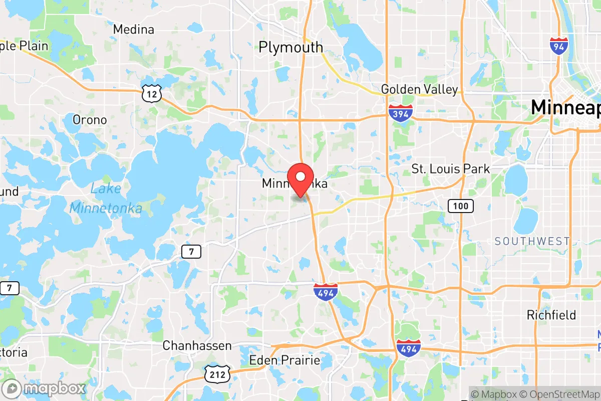
Regional Safe Places
Below is our recommended "safe zones" in Minnesota and the surrounding area based on our strategic heuristics. For most people, it's unrealistic to live in a “safe zone” full-time due to work, family or other personal reasons. They tend to be more rural. However, many of these areas are perfect for second homes and retreat properties that double as a vacation home or even a short-term rental.


Important Note: For informational purposes only. This does not mean nothing bad ever happens in the green zones. Please use common sense. This is based on public data and modeled with AI. We tried to take a conservative approach but mistakes happen. We update this regularly as new information becomes available.
Solar Generator Recommendations
Backup power matters more here than in safer locations. We've picked three solar generators across budgets and capacity tiers — start with the budget unit if you only need a few essentials, or step up if you want to run a fridge and HVAC for days at a time.

Jackery Portable Power Station Explorer 300
Budget OptionPower on the Go: Weighing only 11 lbs, it's convenient to set up and store with book-sized foldable solar panels

BLUETTI Portable Power Station AC180
Designed for both indoor and outdoor scenarios, AC180 is highly capable as it has a robost capacity and continuous output power.

EF ECOFLOW DELTA Pro Ultra Power Station
Upgraded PickEcoFlow DELTA Pro Ultra is a whole-home energy system designed to grow with your family. Integrated with the Smart Home Panel 2, it scales to meet your evolving energy needs — keeping your home powered, intelligent, and secure through every stage of life.
We earn a commission, at no additional cost to you.
Strategic Assessment Analysis
Minnetonka, Minnesota, presents a complex strategic picture for the conservative prepper or survivalist. Its primary advantage is not raw wilderness, but a position of relative resilience within a highly volatile region—a suburban buffer that offers proximity to critical infrastructure while maintaining a degree of separation from the most acute risks of a major metropolitan collapse. The city’s location on the western edge of the Minneapolis-St. Paul metro area, nestled along the shores of Lake Minnetonka, provides a unique blend of natural resources and logistical access that, if leveraged correctly, can serve as a staging ground for longer-term sustainability. However, this is not a retreat; it is a forward operating base, and its viability hinges entirely on your ability to read the terrain—both literal and geopolitical—and plan accordingly.
Geographic position and natural advantages for a strategic relocation
Minnetonka sits at a critical inflection point. It is roughly 15 miles west of downtown Minneapolis, placing it close enough to the economic and logistical hubs of the Upper Midwest, yet far enough to avoid the immediate blast radius of a high-value target like the Federal Reserve Bank or the major transportation corridors along I-94 and I-35W. The city itself is built on a series of rolling hills and lakes, with Lake Minnetonka—a massive, 14,000-acre body of water—forming its southern and western boundary. This water feature is a double-edged sword: it provides an excellent natural barrier against ground-based movement from the south and west, but it also funnels traffic through a limited number of choke points, such as the bridges on Highway 7 and Highway 101. For a prepper, this means defensible positions exist, but they are also predictable. The area’s numerous smaller lakes, wetlands, and wooded ravines offer ample cover and concealment, and the local topography is far more varied than the flat farmland to the south and west. The presence of the Minnesota River Valley just a few miles south adds another layer of natural terrain complexity, which can be used for both travel and ambush avoidance. The climate is a factor: harsh winters with heavy snow and subzero temperatures can be a survival advantage if you are prepared, as they will deter unprepared movement and reduce the operational tempo of any adversary. The growing season is short (roughly 140 days), but the soil in the region is rich glacial till, capable of supporting substantial food production if you have the land and the know-how.
Risks, exposures, and proximity to fallout-relevant landmarks
This is where the analysis gets sobering. Minnetonka’s greatest liability is its proximity to a dense web of high-value targets. Within a 20-mile radius, you have the Minneapolis-St. Paul International Airport (MSP), a major hub for both passenger and cargo traffic, and a likely target for any kinetic or EMP-based attack. The city is also within 25 miles of the Xcel Energy headquarters and the Monticello Nuclear Generating Plant (roughly 35 miles northwest), which, while not a direct fallout risk in a conventional sense, represents a critical infrastructure node that would be contested in any major conflict. The I-494 corridor, which runs just south of Minnetonka, is a primary logistics artery for the entire metro area, and its disruption would cause immediate cascading effects on food, fuel, and medical supply chains. More concerning for the prepper is the concentration of corporate headquarters and data centers in the western suburbs—UnitedHealth Group, Cargill, and several major financial services firms have campuses within a 10-mile radius. In a scenario of civil unrest or economic collapse, these locations become magnets for looting, protest, and potential occupation. The city itself is a wealthy, well-maintained suburb, which means it will be a target for resource-seeking refugees from the inner city and eastern suburbs. The police presence is strong, but in a prolonged crisis, law enforcement will be stretched thin, and the expectation of rapid response will evaporate. The fallout risk from a nuclear event is moderate—prevailing winds from the west would carry contamination away from Minnetonka toward St. Paul, but a ground burst at MSP or the refinery in Rosemount would put the area in a dangerous downwind plume. You are not in a safe zone; you are in a buffer zone that will see significant pressure.
Practical resilience for a relocator: food, water, energy, and defensibility
For the individual or family looking to establish a resilient foothold, Minnetonka offers a mixed bag. Water is abundant—Lake Minnetonka and the numerous smaller lakes provide a virtually unlimited supply, but it is surface water that will require filtration and treatment. The city’s water supply comes from the Mississippi River via the Minneapolis system, which is a single point of failure. You must have your own well or a reliable means of drawing and purifying lake water. The local soil is good for gardening, but most residential lots are small (0.25 to 0.5 acres), limiting large-scale food production. Community gardens exist, but they are not secure. Energy resilience is a challenge: the grid is reliable in normal times, but the area is prone to ice storms and derecho events that can knock out power for days. Solar is viable, but the long, dark winters mean you need a robust battery bank and a backup generator. Natural gas is the primary heating fuel, and that pipeline network is vulnerable to disruption. A wood stove or a pellet stove is a near-necessity for winter survival. Defensibility is the hardest factor. Minnetonka is a suburban grid of cul-de-sacs and arterial roads. There is no natural fortress. The best you can do is choose a property on a dead-end street with a single point of access, preferably backing onto a wooded area or a lake. The local police and fire departments are well-funded and professional, but in a breakdown scenario, you are relying on a thin blue line that will be overwhelmed. The city’s proximity to the metro means that any sustained crisis will bring a wave of displaced persons. Your best defense is obscurity—do not advertise your supplies, do not fly flags that mark you as a target, and build a network of trusted neighbors. The prepper community in Minnesota is active but discreet; you can find like-minded individuals through local gun clubs, shooting ranges, and preparedness meetups, but vet carefully. The state’s gun laws are relatively permissive compared to coastal states, but magazine capacity restrictions and permit-to-carry requirements are in place. Stock up on ammunition and training now, because the supply lines will dry up fast.
The overall strategic picture for Minnetonka is one of calculated risk. It is not a bug-out location; it is a stand-your-ground location for those who have the resources and the mindset to weather a storm in place. The advantages—abundant water, defensible terrain features, a strong local economy, and a relatively stable population—are real, but they are offset by the crushing proximity to a major metropolitan area with all its associated vulnerabilities. If you are looking for a remote retreat in the Northwoods, this is not it. But if you need to remain connected to employment, healthcare, and supply chains while maintaining a credible posture of self-reliance, Minnetonka can work. The key is to treat it as a hardened outpost, not a sanctuary. Build your supplies for a minimum of six months of isolation, invest in water purification and off-grid power, and develop a detailed plan for both sheltering in place and a secondary egress route to the west or north. The city will survive a short-term crisis, but in a long-term collapse, the pressure will become unsustainable. Your window of viability is measured in months, not years. Plan accordingly.
* Values derived from national, state, county, city and local statistics and may differ in a specific area. Last updated: 2026-04-24T15:28:06.000Z
Narrative content on this page is AI-generated and may contain mistakes. Verify any details that matter before acting on them.
ReloMaps may earn a commission from affiliate links at no extra cost to you.