
Photo: Wikipedia
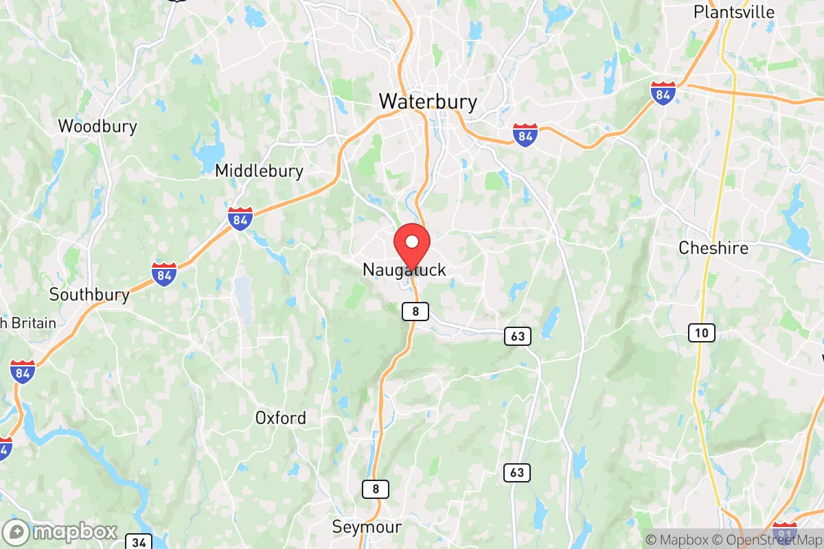
Strategic Assessment of Naugatuck, CT
Multiple tactical vulnerabilities. Population density, target proximity, or disaster risk are likely compounding. A retreat property and exit planning is required.
What does the Strategic Assessment tell us?
Our Strategic Assessment grades tactical survivability of an area. Major population centers, military targets, fallout zones, natural disasters, and border exposure all drive risk — lower exposure means a more defensible position in a crisis.
This is heavily inspired by Joel Skousen's Strategic Relocation book. Highly recommended you checkout the book ($)What does this tell us?
Our Strategic Assessment grades tactical survivability of an area. Major population centers, military targets, fallout zones, natural disasters, and border exposure all drive risk — lower exposure means a more defensible position in a crisis.
This is heavily inspired by Joel Skousen's Strategic Relocation book. Highly recommended you checkout the book ($)Strategic Pillars

Key Distances
Regional Safe Places
Below is our recommended "safe zones" in Connecticut and the surrounding area based on our strategic heuristics. For most people, it's unrealistic to live in a “safe zone” full-time due to work, family or other personal reasons. They tend to be more rural. However, many of these areas are perfect for second homes and retreat properties that double as a vacation home or even a short-term rental.


Important Note: For informational purposes only. This does not mean nothing bad ever happens in the green zones. Please use common sense. This is based on public data and modeled with AI. We tried to take a conservative approach but mistakes happen. We update this regularly as new information becomes available.
Solar Generator Recommendations
Backup power matters more here than in safer locations. We've picked three solar generators across budgets and capacity tiers — start with the budget unit if you only need a few essentials, or step up if you want to run a fridge and HVAC for days at a time.

Jackery Portable Power Station Explorer 300
Budget OptionPower on the Go: Weighing only 11 lbs, it's convenient to set up and store with book-sized foldable solar panels

BLUETTI Portable Power Station AC180
Designed for both indoor and outdoor scenarios, AC180 is highly capable as it has a robost capacity and continuous output power.

EF ECOFLOW DELTA Pro Ultra Power Station
Upgraded PickEcoFlow DELTA Pro Ultra is a whole-home energy system designed to grow with your family. Integrated with the Smart Home Panel 2, it scales to meet your evolving energy needs — keeping your home powered, intelligent, and secure through every stage of life.
We earn a commission, at no additional cost to you.
Strategic Assessment Analysis
Naugatuck, Connecticut, offers a surprisingly resilient position for those prioritizing strategic relocation, balancing proximity to economic hubs with a degree of geographic separation that many preppers find valuable. Nestled in the Naugatuck River Valley and flanked by the hills of western Connecticut, this former industrial borough provides a defensible terrain and a community that has weathered economic shifts without losing its character. For a conservative-leaning individual or family concerned with civic unrest, mass casualty events, or broader societal breakdown, Naugatuck presents a mixed but workable picture—its strengths lie in its natural chokepoints and local resource potential, while its weaknesses stem from its location within a densely populated corridor.
Geographic position and natural defensive advantages in the Naugatuck River Valley
Naugatuck sits in a narrow valley carved by the Naugatuck River, with steep wooded hills rising on both sides, creating a natural funnel that limits approach routes. This topography is a double-edged sword: it makes the town harder to access from multiple directions, which can be a defensive asset during unrest, but it also means that any major disruption on Route 8—the primary north-south artery—can effectively isolate the area. The town is roughly 15 miles northwest of New Haven and 30 miles southwest of Hartford, placing it within the outer ring of Connecticut’s urbanized corridor but far enough to avoid the immediate chaos of a city collapse. The surrounding state forests and watershed lands, including the Naugatuck State Forest and the nearby Mattatuck State Forest, provide buffer zones and potential foraging or retreat areas. For a relocator, the key advantage is that Naugatuck is not a primary target—it lacks the symbolic or logistical significance of a state capital, major port, or military installation—so it would likely be bypassed in a coordinated attack or civil disturbance, at least initially.
Risks, exposures, and proximity to fallout-relevant landmarks
The most significant strategic liability for Naugatuck is its position within the New York City–Boston megalopolis. While the town itself is small (population roughly 31,000), it lies within the fallout shadow of several high-value targets. The Indian Point Energy Center in Buchanan, New York, is roughly 50 miles southwest—well within the range of a radiological release from a disaster or attack. Similarly, the Millstone Nuclear Power Station in Waterford, Connecticut, is about 40 miles southeast, and the Seabrook Station in New Hampshire is about 120 miles northeast. In a worst-case scenario involving multiple nuclear events, Naugatuck could be downwind from one or more of these facilities depending on weather patterns. Additionally, the town’s industrial history has left behind environmental liabilities—former factories and brownfield sites along the river could become secondary hazards if infrastructure fails. The Naugatuck River itself, while a water source, is also a flood risk; the town has experienced significant flooding in the past, and a breakdown of dam maintenance upstream could compound a disaster scenario. For the prepper, these risks mean that a Naugatuck relocation requires a robust plan for evacuation or sheltering in place, with a focus on filtration and stockpiling that accounts for potential contamination.
Practical resilience for a relocator: food, water, energy, and defensibility
On the ground, Naugatuck offers several practical advantages for self-sufficiency. The town has a working-class ethos and a number of older homes with basements, wells, and septic systems—features that are increasingly rare in newer suburban developments. Many properties sit on sloped lots that provide natural drainage and some degree of visual cover from neighbors. The local water supply comes from the Naugatuck Water Company, which draws from reservoirs in the surrounding hills, but a private well on a hillside property would be a major asset for independence. For food, the area has a handful of small farms and farmers’ markets, and the soil in the valley is fertile enough for serious gardening, though the growing season is short (roughly May to October). The nearby towns of Middlebury and Oxford have larger agricultural operations, and a prepper could establish barter relationships with local growers. Energy resilience is a mixed bag: the grid is typical of New England—aging and vulnerable to storms—but the hilly terrain makes solar panel placement challenging on many lots. Wood heat is a viable option, given the surrounding forests, and many homes already have fireplaces or wood stoves. Defensibility is where Naugatuck’s geography shines. The limited road access—primarily Route 8 and a few secondary roads like Route 63 and Route 68—means that a small group could monitor or block approaches with relative ease. The hills provide natural observation points, and the dense tree cover offers concealment. However, the town’s density (roughly 1,200 people per square mile) means that in a prolonged crisis, competition for resources could become intense. A relocator would want to secure a property on the outskirts, ideally on a dead-end road or cul-de-sac with a single egress.
The overall strategic picture for Naugatuck is one of cautious viability. It is not a remote bunker location—it is a working-class New England town with real exposure to the risks of the Northeast Corridor. But for a relocator who values proximity to employment and services during normal times, while maintaining a credible fallback position for bad times, it offers a reasonable balance. The key is to treat Naugatuck as a base of operations rather than a final redoubt. Stockpile for 90 days, secure a property with a well and wood heat, establish relationships with neighbors who share your mindset, and have a bug-out route into the Litchfield Hills or the Berkshires to the north. The town’s industrial past means there are plenty of skilled tradespeople—welders, mechanics, electricians—who would be invaluable in a rebuilding scenario. The conservative-leaning culture of the area, while not overtly political, tends toward self-reliance and skepticism of government overreach, which aligns well with a prepper’s worldview. Naugatuck won’t save you from a direct hit, but it gives you a fighting chance to ride out the storm and rebuild.
* Values derived from national, state, county, city and local statistics and may differ in a specific area. Last updated: 2026-04-30T13:33:15.000Z
Narrative content on this page is AI-generated and may contain mistakes. Verify any details that matter before acting on them.
ReloMaps may earn a commission from affiliate links at no extra cost to you.