Photo: Wikipedia
Strategic Assessment of New Martinsville, WV
Meaningful friction. Expect exposure to either population pressure, blast zones, or natural disaster risk. Consider buying a retreat property.
What does the Strategic Assessment tell us?
Our Strategic Assessment grades tactical survivability of an area. Major population centers, military targets, fallout zones, natural disasters, and border exposure all drive risk — lower exposure means a more defensible position in a crisis.
This is heavily inspired by Joel Skousen's Strategic Relocation book. Highly recommended you checkout the book ($)What does this tell us?
Our Strategic Assessment grades tactical survivability of an area. Major population centers, military targets, fallout zones, natural disasters, and border exposure all drive risk — lower exposure means a more defensible position in a crisis.
This is heavily inspired by Joel Skousen's Strategic Relocation book. Highly recommended you checkout the book ($)Strategic Pillars

Key Distances
Regional Safe Places
Below is our recommended "safe zones" in West Virginia and the surrounding area based on our strategic heuristics. For most people, it's unrealistic to live in a “safe zone” full-time due to work, family or other personal reasons. They tend to be more rural. However, many of these areas are perfect for second homes and retreat properties that double as a vacation home or even a short-term rental.


Important Note: For informational purposes only. This does not mean nothing bad ever happens in the green zones. Please use common sense. This is based on public data and modeled with AI. We tried to take a conservative approach but mistakes happen. We update this regularly as new information becomes available.
Solar Generator Recommendations
Backup power matters more here than in safer locations. We've picked three solar generators across budgets and capacity tiers — start with the budget unit if you only need a few essentials, or step up if you want to run a fridge and HVAC for days at a time.

Jackery Portable Power Station Explorer 300
Budget OptionPower on the Go: Weighing only 11 lbs, it's convenient to set up and store with book-sized foldable solar panels

BLUETTI Portable Power Station AC180
Designed for both indoor and outdoor scenarios, AC180 is highly capable as it has a robost capacity and continuous output power.

EF ECOFLOW DELTA Pro Ultra Power Station
Upgraded PickEcoFlow DELTA Pro Ultra is a whole-home energy system designed to grow with your family. Integrated with the Smart Home Panel 2, it scales to meet your evolving energy needs — keeping your home powered, intelligent, and secure through every stage of life.
We earn a commission, at no additional cost to you.
Strategic Assessment Analysis
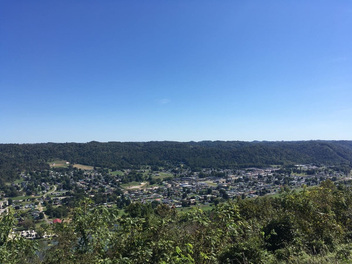
New Martinsville, West Virginia, offers a compelling strategic position for those prioritizing resilience and self-sufficiency, sitting in the northern panhandle along the Ohio River with a population around 5,000. Its location provides a buffer from major metropolitan chaos while maintaining access to critical infrastructure, and the surrounding Wetzel County has a population density of roughly 60 people per square mile, giving you breathing room. The town’s industrial heritage—anchored by the long-standing Ormet aluminum plant and nearby natural gas operations—means there’s a local economic base that doesn’t rely entirely on government or service-sector jobs, a plus for stability. For a relocator with a prepper mindset, this area offers a blend of isolation and connectivity that’s hard to beat in the eastern U.S., but it’s not without its own exposures.
Geographic position and natural advantages for long-term security
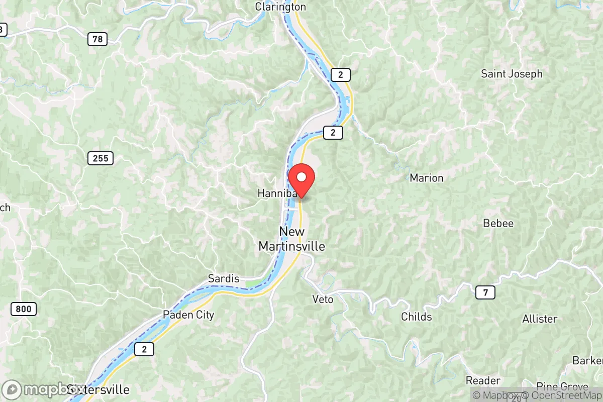
New Martinsville sits on the eastern bank of the Ohio River, which serves as both a water source and a natural barrier to the west, while the surrounding hills of the Appalachian foothills provide elevation and cover. The river gives you a reliable water supply for drinking, irrigation, and potential hydropower, though you’ll need to treat it—the Ohio carries industrial runoff from upstream cities like Pittsburgh and Cincinnati. The terrain is rugged, with steep ridges and narrow valleys that make large-scale troop or vehicle movement difficult, a defensive advantage if things go sideways. You’re roughly 90 miles from Pittsburgh and 120 miles from Columbus, close enough to tap into those markets for trade or resupply in normal times, but far enough that a major event in those cities—say, a dirty bomb or civil unrest—won’t immediately spill over. The area sits atop the Marcellus Shale formation, meaning natural gas extraction is active; you can find landowners leasing mineral rights, and local energy prices are among the lowest in the nation, a practical edge for heating and backup power.
Risks, exposures, and proximity to fallout-relevant landmarks
The biggest strategic downside is the Ohio River itself—it’s a major industrial corridor with chemical plants, refineries, and barge traffic that could become a target or a source of contamination. Upstream, you’ve got the Pittsburgh metro area (roughly 2.3 million people) and the Beaver Valley Nuclear Power Station about 60 miles north, a potential fallout zone if something goes wrong. Downstream, the river passes through Huntington and into Kentucky, so any upstream release of chemicals or radioactive material could affect your water supply for weeks. Closer to home, the Ormet plant has a history of aluminum smelting, which involves hazardous materials like fluoride and cryolite; a fire or explosion there could release toxic fumes depending on wind direction. There’s also the Willis Creek and Fishing Creek watersheds that drain into the Ohio—flash flooding is a real risk after heavy rains, and the town’s low-lying areas near the river have flooded historically, including in 2018 when water reached several feet in some basements. For a prepper, these aren’t deal-breakers, but they demand planning: store water upstream, have a filtration system rated for heavy metals, and know your evacuation routes east into the hills.
Practical resilience for a relocator: food, water, energy, and defensibility
Food security here is decent for a small town. There’s a Walmart and a local grocery store for daily needs, but the real value is in the surrounding farmland and hunting grounds. Wetzel County has over 70% forest cover, with white-tailed deer, turkey, and small game abundant; a family with a rifle and basic trapping skills can supplement protein year-round. The growing season is about 150 days, suitable for corn, beans, squash, and root vegetables, though the clay-heavy soil requires amendment—raised beds or hugelkultur work well. Water is the strong suit: the Ohio River is a massive resource, but you’ll want a backup well or rainwater catchment system for when the river is compromised. Many older homes in the area have hand-dug wells or cisterns, and drilling a new well runs about $15–$25 per foot, with typical depths of 100–200 feet to reach the sandstone aquifer. Energy is a major plus—natural gas is cheap and plentiful, and you can install a whole-house generator running on propane or gas for under $5,000. Solar potential is moderate (about 4.5 peak sun hours per day), but the hilly terrain means you’ll need south-facing slopes or rooftop panels. Defensibility is good: the town has a single main bridge across the Ohio (the New Martinsville Bridge), which can be monitored or blocked, and the surrounding ridges offer natural chokepoints on the two-lane roads leading in. The local police force is small (around 10 officers), and the county sheriff’s office covers a wide area, so in a crisis you’re largely on your own—which is exactly how many preppers prefer it.
The overall strategic picture for New Martinsville is one of calculated trade-offs. You get a low-population buffer zone with abundant natural resources—water, gas, timber, game—and a defensible terrain that discourages casual intrusion. The proximity to the Ohio River and its industrial corridor is a double-edged sword: it provides economic lifelines and a water source, but also introduces contamination and targeting risks that require active mitigation. For a conservative-leaning relocator worried about urban collapse, federal overreach, or mass casualty events, this area offers a realistic middle ground—not a remote bunker in the Rockies, but a working-class town with the bones to sustain a self-reliant lifestyle. The key is to buy property above the floodplain, invest in water filtration and backup power, and build relationships with the local farming and hunting community. If you’re looking for a place to ride out the storm while still being able to drive to a hardware store, New Martinsville deserves a serious look.
* Values derived from national, state, county, city and local statistics and may differ in a specific area. Last updated: 2026-04-21T09:25:29.000Z
Narrative content on this page is AI-generated and may contain mistakes. Verify any details that matter before acting on them.
ReloMaps may earn a commission from affiliate links at no extra cost to you.