Photo: Wikipedia
Strategic Assessment of Quay County
Deep buffer from population centers and strategic targets. Low natural disaster risk and minimal exposure to border or coastal threats.
What does the Strategic Assessment tell us?
Our Strategic Assessment grades tactical survivability of an area. Major population centers, military targets, fallout zones, natural disasters, and border exposure all drive risk — lower exposure means a more defensible position in a crisis.
This is heavily inspired by Joel Skousen's Strategic Relocation book. Highly recommended you checkout the book ($)What does this tell us?
Our Strategic Assessment grades tactical survivability of an area. Major population centers, military targets, fallout zones, natural disasters, and border exposure all drive risk — lower exposure means a more defensible position in a crisis.
This is heavily inspired by Joel Skousen's Strategic Relocation book. Highly recommended you checkout the book ($)Strategic Pillars

Key Distances
Strategic Assessment Analysis
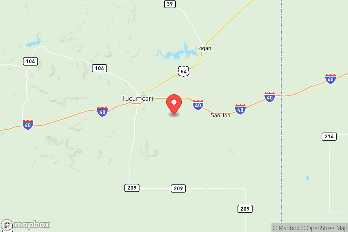
Quay County, New Mexico, occupies a strategic sweet spot for those serious about geographic resilience: far enough from major population centers to avoid the initial ripple effects of a collapse, yet still wired into the interstate and rail corridors that keep supplies moving. The county's anchor, Tucumcari, sits at the crossroads of I-40 and U.S. 54, offering a logistical perch that's both isolated and connected—a rare combination when you're planning for long-term stability. For a relocator whose calculus includes civic unrest, supply-chain disruptions, or mass-casualty events, Quay County holds up as a place that's been quietly populated by ranching and railroad families for generations, not by suburban flight, which gives it a different kind of social fabric than what you'd find closer to Albuquerque or Amarillo.
Geographic position and natural advantages that matter when things go sideways
Situated in the High Plains of eastern New Mexico, Quay County sits roughly midway between the Texas Panhandle and the central Rio Grande Valley—close enough to reach I-40 commerce but too far for the kind of population bleed that stresses local resources. The county's eastern boundary presses against the Texas state line, meaning a relocator here can consider a secondary position into the Texas Panhandle without crossing major chokepoints. The Canadian River snakes through the northern part of the county, and while it's not the Mississippi, it provides a perennial water source that most counties in this part of the state lack. Ute Lake, near the town of Logan, is a key asset: a 9,000-acre reservoir that feeds local irrigation and could serve as a long-term water security anchor for a small group willing to manage it. The terrain is mostly open grassland and mesa breaks—not defensible like mountain country, but offering long sightlines and limited cover for anyone approaching. For a relocator looking to avoid natural-disaster zones, Quay County sits well outside hurricane tracks, earthquake zones, and wildfire corridors that plague the West, though drought and wind are constant companions.
Fallout risks, proximity to targets, and what you should actually worry about
Let's be direct: Quay County is not near any Tier-1 strategic target like a major port, petroleum refinery, or high-value military base. Cannon Air Force Base, located about 70 miles south near Clovis, is a special-operations hub, but that's distant enough that a ground-zero strike at Cannon would not directly threaten Tucumcari or Logan. The bigger risk is the I-40 corridor itself, which runs right through Tucumcari—it's a critical east-west logistics artery, and in a national emergency, that highway becomes both a target for disruption and a funnel for displaced populations. Anyone relocating here must plan for the possibility of I-40 becoming a clogged evacuation route rather than a supply line. The Union Pacific rail line paralleling the interstate is another risk vector, though less likely to be a primary target than facilities in the Texas Triangle. The county's saving grace is its low population density—about 3.5 people per square mile—meaning a chemical or radiological event elsewhere is unlikely to concentrate here. The real exposure is economic: Quay County's tax base is thin, its healthcare infrastructure limited to a small regional hospital in Tucumcari, and its power grid is part of the wider Southwest grid that has shown fragility under load. A determined prepper would want to harden their own energy and medical capacity, not depend on the county to provide it.
Making it work: food production, water access, energy independence, and defensibility on the high plains
Water is the linchpin of any long-term resilience plan in the West, and Quay County has more of it than most of its neighbors. Ute Lake and the underlying Ogallala aquifer provide potential for small-scale irrigation and livestock watering, though the aquifer is depleting across the region. For a relocator, securing a parcel with a domestic well permit near the Canadian River or Ute Lake is the most viable long-term water strategy. The growing season is about 180 days—tight but workable—and the county has a long history of dryland winter wheat and cattle grazing. Anyone serious about food production will need to invest in hoop houses or cold frames to extend the season into the shoulder months. Energy is straightforward: the area gets over 280 sunny days a year, making solar a natural primary source for off-grid setups, though battery storage is a must given wind patterns that can knock out overhead lines. Wind speeds average 13-15 mph year-round, so a small wind turbine paired with solar creates a reliable hybrid system. For personal security, the county's open terrain means you'll see anyone approaching from miles away, but that same openness makes a fortified compound visible from the highway. The smarter play is a low-visibility setup with buried cisterns, a secure perimeter, and a retreat plan into the mesa country north of the river. The community itself is small—Tucumcari holds about 5,000 people—and while the local culture is generally conservative and self-reliant, the key is to integrate quietly; showing up as a prepper looking to "bug in" will mark you as an outsider in a place where outsiders are remembered for decades.
The overall strategic picture for Quay County is this: it's not the most defensible piece of ground in the country, but it offers a real option for a relocator who wants to be off the primary target list while still staying connected to the national logistics network. The water assets at Ute Lake and along the Canadian River give it a sustainability edge over most High Plains counties, and the long sightlines and low population density offer genuine security advantages over more crowded retreat areas in the Rockies or Ozarks. The trade-offs are real—extreme weather, thin local infrastructure, and the risk of I-40 becoming a refugee corridor in a crisis—but for a family or small group willing to build their own support systems, Quay County represents a sober, defensible bet on the high plains where the margins are thin but the neighbors are few and the water runs year-round.
* Values derived from national, state, county, city and local statistics and may differ in a specific area. Last updated: 2026-05-27T20:57:30.000Z
Narrative content on this page is AI-generated and may contain mistakes. Verify any details that matter before acting on them.
ReloMaps may earn a commission from affiliate links at no extra cost to you.