
Photo: Wikipedia
Strategic Assessment of Rio Arriba County
Strong survivability profile. Good buffer from population centers, with manageable environmental and tactical risks.
What does the Strategic Assessment tell us?
Our Strategic Assessment grades tactical survivability of an area. Major population centers, military targets, fallout zones, natural disasters, and border exposure all drive risk — lower exposure means a more defensible position in a crisis.
This is heavily inspired by Joel Skousen's Strategic Relocation book. Highly recommended you checkout the book ($)What does this tell us?
Our Strategic Assessment grades tactical survivability of an area. Major population centers, military targets, fallout zones, natural disasters, and border exposure all drive risk — lower exposure means a more defensible position in a crisis.
This is heavily inspired by Joel Skousen's Strategic Relocation book. Highly recommended you checkout the book ($)Strategic Pillars

Key Distances
Strategic Assessment Analysis
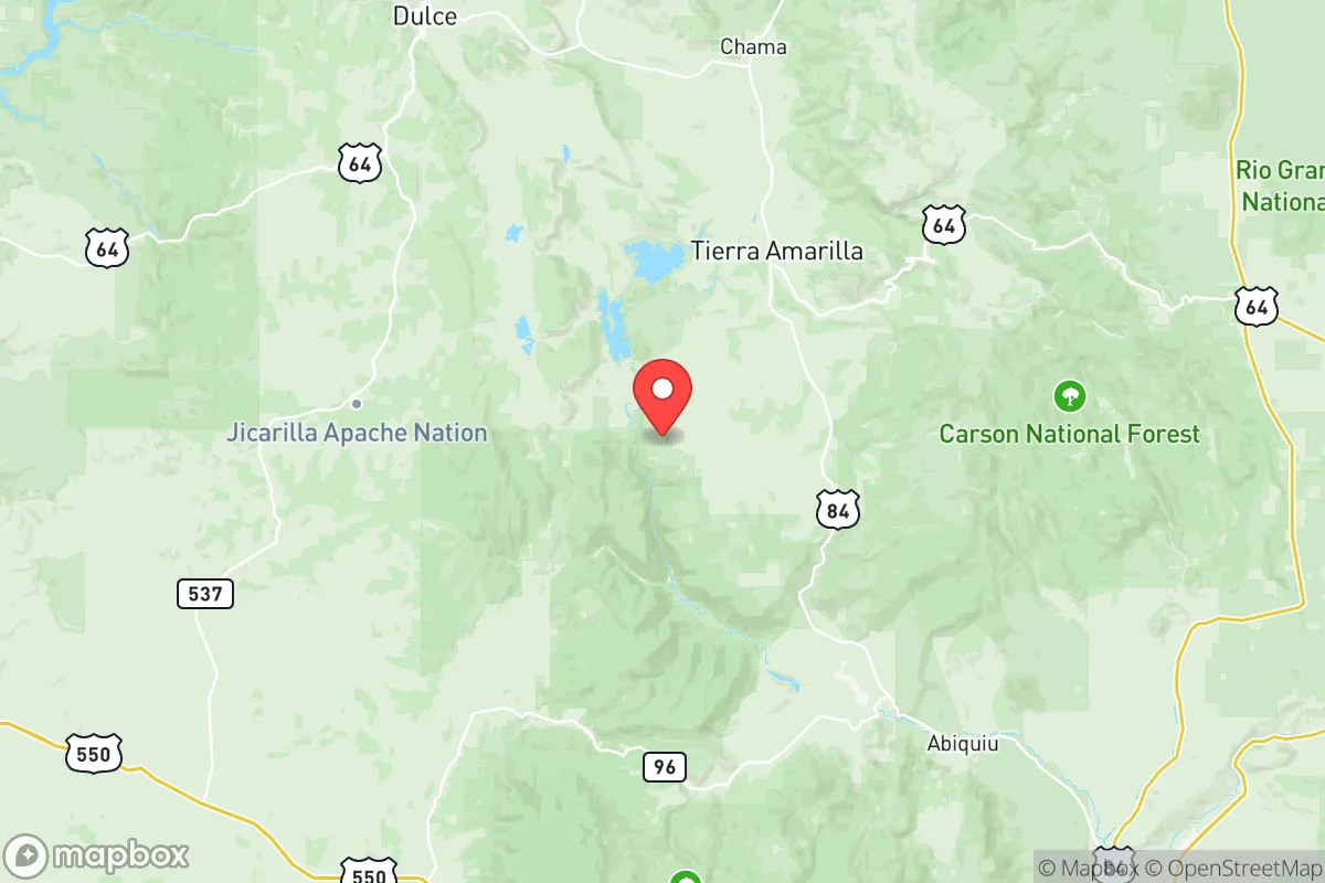
Rio Arriba County, New Mexico, offers a compelling mix of isolation and resource abundance for those prioritizing long-term resilience. Its position in the high desert of northern New Mexico, anchored by the county seat of Española and stretching north to the Colorado border, places it far from major metropolitan chaos while still providing access to critical infrastructure. For a relocator with a prepper mindset, the county’s sparse population, rugged terrain, and natural water sources create a foundation for self-sufficiency, but the presence of nearby high-value targets like Los Alamos National Laboratory introduces real fallout risks that demand careful planning.
Geographic position and natural advantages for self-reliance
Rio Arriba County sits at the intersection of the Rio Grande Valley and the southern Rocky Mountains, giving it a strategic mix of defensible high ground and fertile river bottoms. The county spans over 5,800 square miles, most of it within the Carson National Forest and the Jicarilla Apache Nation, with population density hovering around six people per square mile. Towns like Tierra Amarilla, Chama, and Abiquiú are small, tight-knit communities where everyone knows their neighbors — a social structure that naturally resists outside disruption. The Rio Grande and the Chama River run through the county, providing reliable surface water even during drought years, and the surrounding mountains offer timber for construction and fuel. Elevations range from 5,500 feet in Española to over 10,000 feet in the San Juan Mountains, meaning microclimates that can support diverse agriculture if you know where to plant. For a relocator, this geography means you can find a remote homestead with year-round water, forest cover for concealment, and enough elevation to avoid the worst of the lowland heat. The county’s position also puts it within a day’s drive of multiple states — Colorado, Arizona, Utah, Texas — without being near any single major city’s sprawl.
Risks, exposures, and proximity to high-value targets
The single biggest strategic liability in Rio Arriba County is its proximity to Los Alamos National Laboratory, located just south of the county line in Los Alamos County. LANL is a primary nuclear weapons research and development facility — a top-tier target for any adversary considering a first strike or a sabotage event. Depending on wind patterns, a detonation or major accident at the lab could send fallout directly over the Española Valley and up into the Chama region. The lab is roughly 30 miles from Española as the crow flies, and prevailing winds often blow from the southwest, meaning the county lies in a potential fallout plume corridor. Additionally, the San Juan Generating Station (a coal-fired power plant) near Farmington is about 80 miles west, and while not a nuclear target, its infrastructure could be a secondary concern during grid-down scenarios. The county itself has no major industrial or military targets — no refineries, no ports, no large military bases — which is a net positive. However, the Jicarilla Apache Nation at Dulce has natural gas fields and pipelines that could be vulnerable to sabotage. The biggest risk for a relocator is not direct attack but the cascade effects: if Los Alamos is compromised, the entire region could become a no-go zone for years. Preppers should factor in a 50-mile buffer from LANL when selecting a specific property, favoring areas north of Chama or deep into the Carson National Forest.
Practical resilience: food, water, energy, and defensibility
Water is the county’s strongest card. The Rio Grande and Chama River systems are fed by mountain snowpack, and many properties have legal surface water rights or access to acequias — community irrigation ditches that have operated for centuries. Abiquiú Lake and Heron Lake provide additional reservoir storage, and groundwater is generally accessible at reasonable depths in the valley floors. For food, the growing season is short (120–150 days) but intense; you can raise cold-hardy crops like potatoes, beans, squash, and apples, and the surrounding national forest offers game — elk, mule deer, wild turkey. Livestock grazing is common, and small-scale poultry and goats are practical. Energy is a mixed bag: the county has abundant solar potential (over 280 sunny days per year), but winter snow and high winds can challenge off-grid setups. Wood heating is standard, and the national forest permits firewood collection. Defensibility is excellent in the mountainous northern half — narrow canyons, single-lane roads, and vast tracts of public land make it easy to control access. The county’s law enforcement presence is thin; the Rio Arriba County Sheriff’s Office covers a huge area with limited deputies, so self-reliance is not optional. For a relocator, the ideal setup is a property with its own well, solar panels with battery backup, a wood stove, and a defensible perimeter — preferably off a dead-end road in the El Rito or Cordova areas, where neighbors are few and far between.
Overall, Rio Arriba County presents a high-risk, high-reward strategic picture for the conservative prepper. Its natural advantages — water, timber, isolation, and a population that values independence — are genuine assets for weathering civic unrest or a long-term grid-down event. But the shadow of Los Alamos cannot be ignored; any relocator must weigh the benefits of remote mountain living against the real possibility of contamination from a facility that is a prime target. For those willing to push north of Chama or into the deep forest, the county offers one of the best combinations of defensible terrain and renewable resources in the Southwest. Just know that if the worst happens, you’ll need to be ready to move — and have a secondary location scouted in Colorado or Utah as a fallback.
* Values derived from national, state, county, city and local statistics and may differ in a specific area. Last updated: 2026-05-18T12:33:21.000Z
Narrative content on this page is AI-generated and may contain mistakes. Verify any details that matter before acting on them.
ReloMaps may earn a commission from affiliate links at no extra cost to you.