Photo: Wikipedia
Strategic Assessment of Santa Clarita, CA
Multiple tactical vulnerabilities. Population density, target proximity, or disaster risk are likely compounding. A retreat property and exit planning is required.
What does the Strategic Assessment tell us?
Our Strategic Assessment grades tactical survivability of an area. Major population centers, military targets, fallout zones, natural disasters, and border exposure all drive risk — lower exposure means a more defensible position in a crisis.
This is heavily inspired by Joel Skousen's Strategic Relocation book. Highly recommended you checkout the book ($)What does this tell us?
Our Strategic Assessment grades tactical survivability of an area. Major population centers, military targets, fallout zones, natural disasters, and border exposure all drive risk — lower exposure means a more defensible position in a crisis.
This is heavily inspired by Joel Skousen's Strategic Relocation book. Highly recommended you checkout the book ($)Strategic Pillars

Key Distances
Regional Safe Places
Below is our recommended "safe zones" in California and the surrounding area based on our strategic heuristics. For most people, it's unrealistic to live in a “safe zone” full-time due to work, family or other personal reasons. They tend to be more rural. However, many of these areas are perfect for second homes and retreat properties that double as a vacation home or even a short-term rental.


Important Note: For informational purposes only. This does not mean nothing bad ever happens in the green zones. Please use common sense. This is based on public data and modeled with AI. We tried to take a conservative approach but mistakes happen. We update this regularly as new information becomes available.
Solar Generator Recommendations
Backup power matters more here than in safer locations. We've picked three solar generators across budgets and capacity tiers — start with the budget unit if you only need a few essentials, or step up if you want to run a fridge and HVAC for days at a time.

Jackery Portable Power Station Explorer 300
Budget OptionPower on the Go: Weighing only 11 lbs, it's convenient to set up and store with book-sized foldable solar panels

BLUETTI Portable Power Station AC180
Designed for both indoor and outdoor scenarios, AC180 is highly capable as it has a robost capacity and continuous output power.

EF ECOFLOW DELTA Pro Ultra Power Station
Upgraded PickEcoFlow DELTA Pro Ultra is a whole-home energy system designed to grow with your family. Integrated with the Smart Home Panel 2, it scales to meet your evolving energy needs — keeping your home powered, intelligent, and secure through every stage of life.
We earn a commission, at no additional cost to you.
Strategic Assessment Analysis
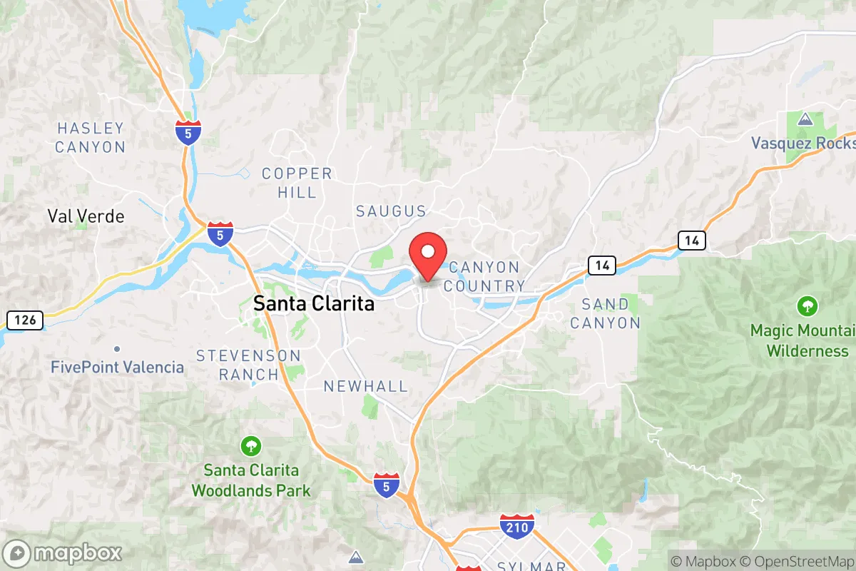
Santa Clarita offers a surprisingly strong strategic position for those prioritizing resilience, sitting far enough from the urban core of Los Angeles to avoid the worst of a collapse scenario while remaining close enough to leverage resources if the grid holds. Its location in the Santa Clarita Valley, flanked by the Angeles National Forest and the San Gabriel Mountains, provides natural chokepoints and defensible terrain that most suburban sprawl simply lacks. For a relocator thinking about civic unrest, supply chain disruptions, or mass casualty events, this area checks several boxes that other parts of Southern California do not. The key is understanding both the advantages and the very real exposures that come with being within 35 miles of one of the most volatile metropolitan regions in the country.
Geographic position and natural advantages for long-term security
The valley's geography is its strongest asset. Santa Clarita sits in a natural bowl, with the Sierra Pelona Mountains to the north and the San Gabriel Mountains to the south and east. This creates a funnel effect for access: only a handful of major routes—Interstate 5, State Route 14, and a few two-lane mountain roads—connect the valley to the rest of Los Angeles County. In a grid-down or civil unrest scenario, those chokepoints can be monitored or controlled far more easily than the sprawling flatlands of the San Fernando Valley. The elevation, averaging around 1,200 feet, also provides a slight climate buffer; summer temperatures are several degrees cooler than the LA basin, and the area is less prone to the coastal fog that can complicate navigation or solar generation. The nearby Angeles National Forest offers thousands of acres of public land for hunting, foraging, and retreat if needed, though it's worth noting that fire restrictions and federal oversight apply. For a prepper, the ability to move into higher terrain or to cache supplies in the forest is a tangible advantage that most suburban communities in California simply do not have.
Risks, exposures, and proximity to fallout-relevant landmarks
The most significant vulnerability is proximity to Los Angeles. Santa Clarita is roughly 35 miles from downtown LA, 20 miles from the Port of Los Angeles/Long Beach complex, and within 50 miles of multiple military installations—including Naval Base Ventura County and Edwards Air Force Base. In a mass casualty event, a nuclear incident, or a major terrorist strike on the port or government infrastructure, fallout patterns could easily sweep northward through the Cajon Pass or over the San Gabriel Mountains, depending on wind direction. The I-5 corridor, which runs directly through Santa Clarita, is a primary evacuation route for the entire San Fernando Valley. In a panic scenario, that road will be gridlocked within hours, and the valley's limited exit routes mean that anyone trying to leave will be trapped alongside millions of others. Additionally, the area sits near the San Andreas Fault—the 1857 Fort Tejon earthquake originated just north of here—and a major seismic event could sever water lines, natural gas pipelines, and the aqueducts that supply the region. The 1994 Northridge earthquake caused significant damage in Santa Clarita, and a repeat event would compound the risks of civil unrest as resources become scarce. For the strategic relocator, these are not deal-breakers, but they demand serious planning: multiple evacuation routes, a robust water storage plan, and a willingness to bug in for weeks rather than bug out.
Practical resilience for a relocator: food, water, energy, and defensibility
Water is the single biggest concern. Santa Clarita relies heavily on the State Water Project and the California Aqueduct, both of which are vulnerable to earthquake damage, drought politics, and potential sabotage. The local groundwater basin, the Santa Clara River Valley aquifer, is managed by the Santa Clarita Valley Water Agency and has been overdrafted in past dry cycles. A relocator should plan for at least two weeks of stored water per person, and ideally a rainwater catchment system if property allows—though local ordinances may restrict large-scale collection. Food security is more promising. The surrounding agricultural areas in the Antelope Valley and the Central Valley are within a few hours' drive, and the Santa Clarita Farmers Market operates year-round. For long-term storage, the dry climate (average humidity around 40%) is favorable for dehydrated goods, and the area has several Costco and Walmart locations that can serve as supply hubs before a crisis. Energy resilience is mixed. The grid is part of Southern California Edison's network, which has experienced Public Safety Power Shutoffs during high fire risk days. Solar adoption is growing, but net metering policies have become less favorable. A generator with a propane or natural gas hookup is a practical investment, and wood-burning fireplaces are common in older homes. Defensibility is where Santa Clarita truly shines for the prepared individual. The valley's layout—with its narrow entry points, hillside neighborhoods, and limited through-streets—makes it easier to secure a perimeter than in a flat, grid-based suburb. Many homes in areas like Stevenson Ranch or Valencia have gated communities or cul-de-sacs that naturally slow vehicle access. For a single person or a family willing to invest in reinforced doors, window film, and a good security camera system, the terrain works in your favor.
The overall strategic picture for Santa Clarita is one of calculated risk. It is not a remote bunker location, nor is it a high-desert compound with total isolation. What it offers is a defensible valley with natural chokepoints, reasonable access to forest resources, and a population that is largely suburban and middle-class—not the dense, high-crime urban core that would become a war zone in a collapse. The downsides are real: proximity to LA, dependence on fragile infrastructure, and the very real possibility of being caught in a mass evacuation. But for the relocator who wants to stay within driving distance of work, family, or medical care while still having a fighting chance at self-sufficiency, Santa Clarita is one of the better options in Southern California. The key is to treat it as a base of operations, not a final retreat. Have a plan for the first 72 hours, store what you can, and know your exit routes before you need them. If you do that, this valley can work for you. If you don't, the I-5 will remind you exactly how fast a good location can turn into a trap.
* Values derived from national, state, county, city and local statistics and may differ in a specific area. Last updated: 2026-04-24T12:44:37.000Z
Narrative content on this page is AI-generated and may contain mistakes. Verify any details that matter before acting on them.
ReloMaps may earn a commission from affiliate links at no extra cost to you.