
Photo: Wikipedia
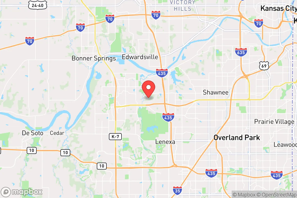
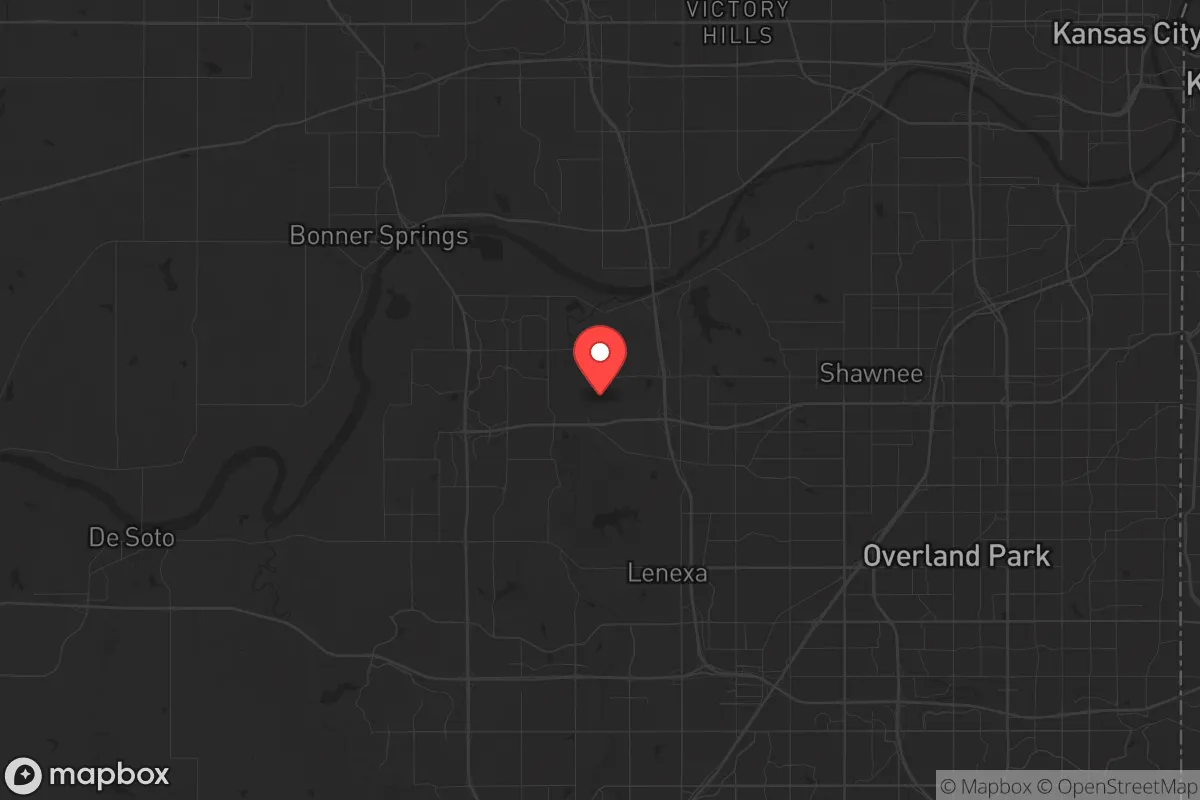
Strategic Assessment of Shawnee, KS
Multiple tactical vulnerabilities. Population density, target proximity, or disaster risk are likely compounding. A retreat property and exit planning is required.
What does the Strategic Assessment tell us?
Our Strategic Assessment grades tactical survivability of an area. Major population centers, military targets, fallout zones, natural disasters, and border exposure all drive risk — lower exposure means a more defensible position in a crisis.
This is heavily inspired by Joel Skousen's Strategic Relocation book. Highly recommended you checkout the book ($)What does this tell us?
Our Strategic Assessment grades tactical survivability of an area. Major population centers, military targets, fallout zones, natural disasters, and border exposure all drive risk — lower exposure means a more defensible position in a crisis.
This is heavily inspired by Joel Skousen's Strategic Relocation book. Highly recommended you checkout the book ($)Strategic Pillars

Key Distances
Regional Safe Places
Below is our recommended "safe zones" in Kansas and the surrounding area based on our strategic heuristics. For most people, it's unrealistic to live in a “safe zone” full-time due to work, family or other personal reasons. They tend to be more rural. However, many of these areas are perfect for second homes and retreat properties that double as a vacation home or even a short-term rental.
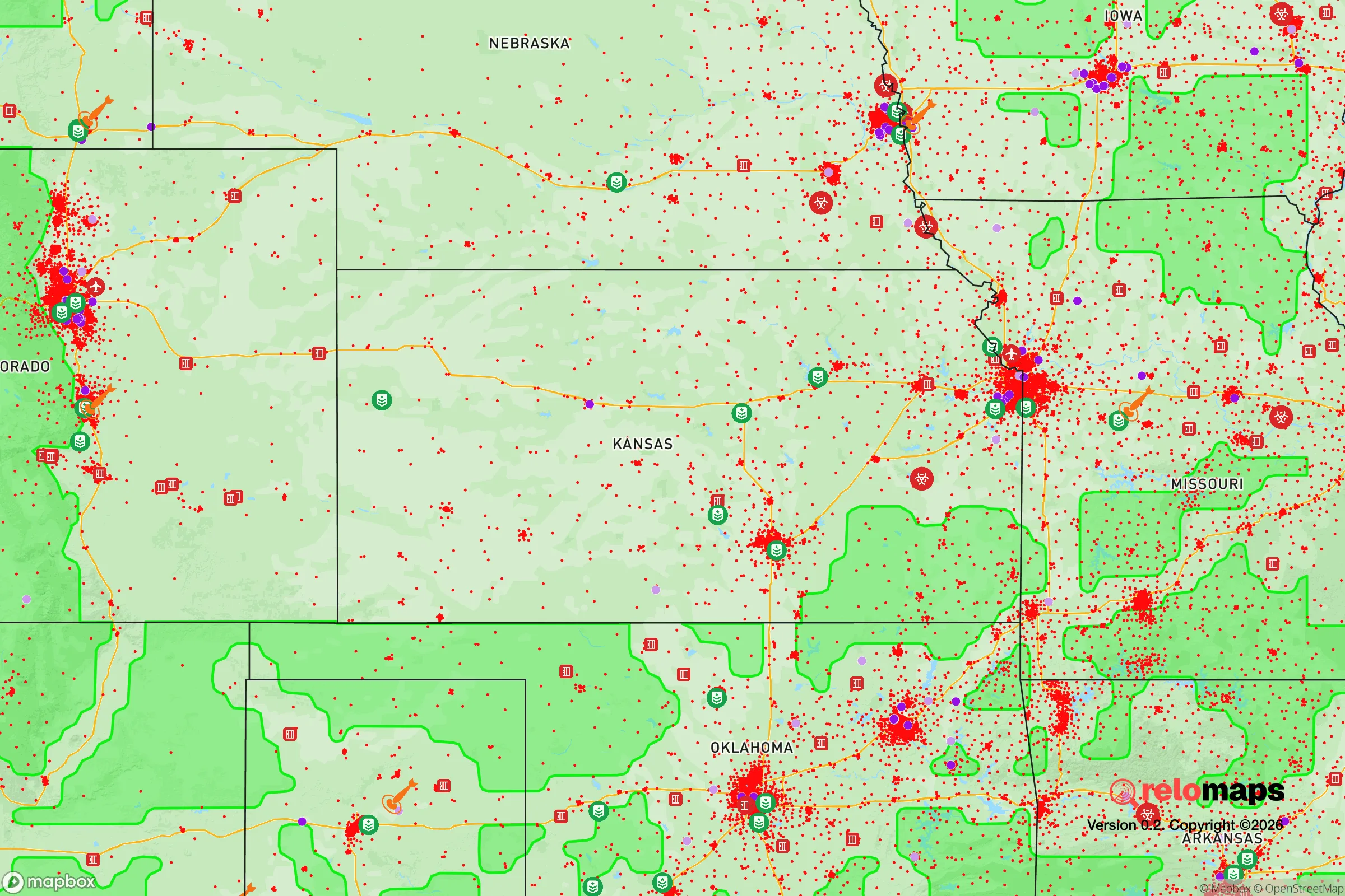
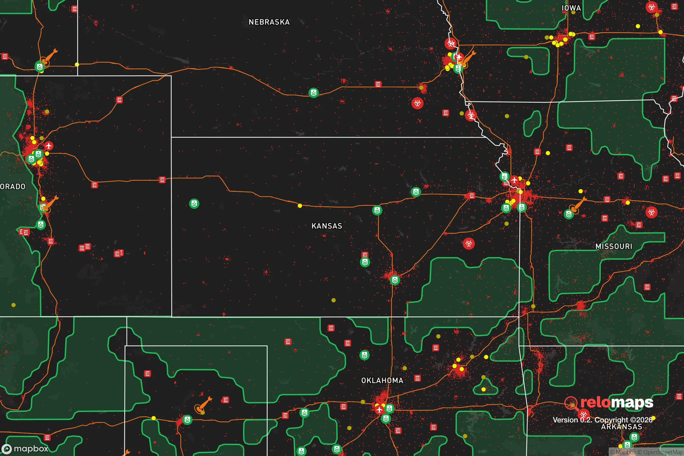
Important Note: For informational purposes only. This does not mean nothing bad ever happens in the green zones. Please use common sense. This is based on public data and modeled with AI. We tried to take a conservative approach but mistakes happen. We update this regularly as new information becomes available.
Solar Generator Recommendations
Backup power matters more here than in safer locations. We've picked three solar generators across budgets and capacity tiers — start with the budget unit if you only need a few essentials, or step up if you want to run a fridge and HVAC for days at a time.

Jackery Portable Power Station Explorer 300
Budget OptionPower on the Go: Weighing only 11 lbs, it's convenient to set up and store with book-sized foldable solar panels

BLUETTI Portable Power Station AC180
Designed for both indoor and outdoor scenarios, AC180 is highly capable as it has a robost capacity and continuous output power.

EF ECOFLOW DELTA Pro Ultra Power Station
Upgraded PickEcoFlow DELTA Pro Ultra is a whole-home energy system designed to grow with your family. Integrated with the Smart Home Panel 2, it scales to meet your evolving energy needs — keeping your home powered, intelligent, and secure through every stage of life.
We earn a commission, at no additional cost to you.
Strategic Assessment Analysis
Shawnee, Kansas, presents a mixed strategic picture for the conservative prepper or survivalist. Its primary advantage is its position within the Kansas City metropolitan area, offering access to resources and economic stability, but this very proximity to a major urban center introduces significant vulnerabilities. For those prioritizing resilience against civic unrest, mass casualty events, and large-scale disasters, Shawnee requires a clear-eyed assessment of its trade-offs between convenience and security. The city’s location in northeastern Kansas, roughly 15 miles from downtown Kansas City, places it within the blast and fallout zones of a potential nuclear event targeting the metro area, while its suburban character offers some buffer from the immediate chaos of a city collapse.
Geographic position and natural advantages for long-term survival
Shawnee sits in the Kansas River Valley, a region with relatively fertile soil and a temperate climate that supports four distinct seasons. The area receives an average of 38 inches of rainfall annually, which is above the national average and beneficial for off-grid water collection and small-scale agriculture. The terrain is gently rolling, with the Kansas River to the north and numerous creeks and streams—like Mill Creek and Shawnee Mission Creek—providing natural water sources. The city’s elevation, around 1,000 feet, offers no significant defensive high ground, but the surrounding landscape is not so flat as to be indefensible. The presence of the Shawnee Mission Park, a 1,600-acre county park with a 47-acre lake, provides a potential emergency water source and foraging area, though it would be heavily contested in a collapse scenario. The region is also within a day’s drive of the Flint Hills to the west, a sparsely populated grassland that could serve as a bug-out destination for those willing to leave the suburban grid.
Risks, exposures, and proximity to fallout-relevant landmarks
The most glaring vulnerability for Shawnee is its proximity to the Kansas City metropolitan area, a population center of over 2 million people. In the event of a nuclear strike on Kansas City—a plausible target given its transportation hubs, military installations (Whiteman Air Force Base is 60 miles southeast), and economic significance—Shawnee would likely experience significant fallout. The prevailing westerly winds mean fallout from a detonation to the east could drift over the city, while a ground burst could contaminate the Kansas River watershed. The city is also near the BNSF Railway mainline and Interstate 35, both critical infrastructure that could become chokepoints or targets during civil unrest. The nearby Johnson County Executive Airport (about 10 miles south) and the New Century AirCenter (20 miles southwest) are secondary targets for any adversary seeking to disrupt regional logistics. For the prepper, the concentration of population in Johnson County—over 600,000 residents—means that any grid-down event would trigger rapid resource depletion and potential civil disorder, as suburbanites with limited survival skills compete for supplies. The city’s reliance on the Missouri River for its water supply (via Kansas City’s treatment plants) is a single point of failure; a disruption to that system would leave Shawnee without municipal water within days.
Practical resilience for a relocator: food, water, energy, and defensibility
For the individual or family relocating to Shawnee with a prepper mindset, practical resilience requires deliberate planning. The city’s water supply is vulnerable, as noted, but private wells are possible in some outlying areas of Shawnee, particularly in the western parts near the Kansas River. Rainwater collection is legal in Kansas, and with average annual rainfall, a 1,000-gallon cistern system could provide a family of four with emergency water for several months. Food security is moderate: the surrounding farmland produces corn, soybeans, and wheat, but local grocery stores rely on just-in-time delivery, meaning shelves empty within 72 hours of a disruption. Community gardens and backyard chicken coops are permitted in most residential zones, though homeowners’ associations in some subdivisions may restrict them. Energy resilience is a weak point; the grid is served by Evergy, which has faced reliability issues during extreme weather (e.g., the 2021 winter storm). Solar panels with battery storage are a viable investment, as Kansas offers net metering, but the region’s cloudy winters reduce solar yield. Natural gas is widely available for heating, but a propane backup generator is a more robust option for those who can afford it. Defensibility is the biggest challenge: Shawnee is a typical suburban sprawl with cul-de-sacs and grid-like streets, offering no natural chokepoints. A single-family home on a half-acre lot provides some standoff, but neighbors are close, and noise discipline is difficult. The city’s police department is well-funded (Johnson County is one of the wealthiest in the nation), but in a widespread collapse, law enforcement would be overwhelmed. A better defensive posture would be a property on the western edge of Shawnee, near the rural interface, where you have more land and fewer neighbors.
The overall strategic picture for Shawnee is one of calculated risk. It is not a hardcore survivalist’s paradise—it lacks the remoteness, defensible terrain, and resource independence of a mountain retreat. However, for the conservative relocator who values economic opportunity, good schools, and a stable community while maintaining a low-profile prepper lifestyle, Shawnee offers a workable middle ground. The key is to treat it as a base of operations, not a final redoubt. Build your supplies, harden your home, and have a bug-out plan for the Flint Hills or rural Missouri if the SHTF. The city’s wealth and infrastructure are a double-edged sword: they provide comfort in normal times but become liabilities in a crisis. If you can navigate that tension, Shawnee can be a smart, strategic choice for those who want to be prepared without living off-grid. Just don’t mistake its suburban calm for true security—the threats are real, and they’re closer than you think.
* Values derived from national, state, county, city and local statistics and may differ in a specific area. Last updated: 2026-05-03T06:02:22.000Z
Narrative content on this page is AI-generated and may contain mistakes. Verify any details that matter before acting on them.
ReloMaps may earn a commission from affiliate links at no extra cost to you.