Photo: Wikipedia
Strategic Assessment of Springdale, AR
Workable tactical position. Some exposure to population density or targets, but generally defensible in a crisis.
What does the Strategic Assessment tell us?
Our Strategic Assessment grades tactical survivability of an area. Major population centers, military targets, fallout zones, natural disasters, and border exposure all drive risk — lower exposure means a more defensible position in a crisis.
This is heavily inspired by Joel Skousen's Strategic Relocation book. Highly recommended you checkout the book ($)What does this tell us?
Our Strategic Assessment grades tactical survivability of an area. Major population centers, military targets, fallout zones, natural disasters, and border exposure all drive risk — lower exposure means a more defensible position in a crisis.
This is heavily inspired by Joel Skousen's Strategic Relocation book. Highly recommended you checkout the book ($)Strategic Pillars

Key Distances
Regional Safe Places
Below is our recommended "safe zones" in Arkansas and the surrounding area based on our strategic heuristics. For most people, it's unrealistic to live in a “safe zone” full-time due to work, family or other personal reasons. They tend to be more rural. However, many of these areas are perfect for second homes and retreat properties that double as a vacation home or even a short-term rental.


Important Note: For informational purposes only. This does not mean nothing bad ever happens in the green zones. Please use common sense. This is based on public data and modeled with AI. We tried to take a conservative approach but mistakes happen. We update this regularly as new information becomes available.
Solar Generator Recommendations
Backup power matters more here than in safer locations. We've picked three solar generators across budgets and capacity tiers — start with the budget unit if you only need a few essentials, or step up if you want to run a fridge and HVAC for days at a time.

Jackery Portable Power Station Explorer 300
Budget OptionPower on the Go: Weighing only 11 lbs, it's convenient to set up and store with book-sized foldable solar panels

BLUETTI Portable Power Station AC180
Designed for both indoor and outdoor scenarios, AC180 is highly capable as it has a robost capacity and continuous output power.

EF ECOFLOW DELTA Pro Ultra Power Station
Upgraded PickEcoFlow DELTA Pro Ultra is a whole-home energy system designed to grow with your family. Integrated with the Smart Home Panel 2, it scales to meet your evolving energy needs — keeping your home powered, intelligent, and secure through every stage of life.
We earn a commission, at no additional cost to you.
Strategic Assessment Analysis
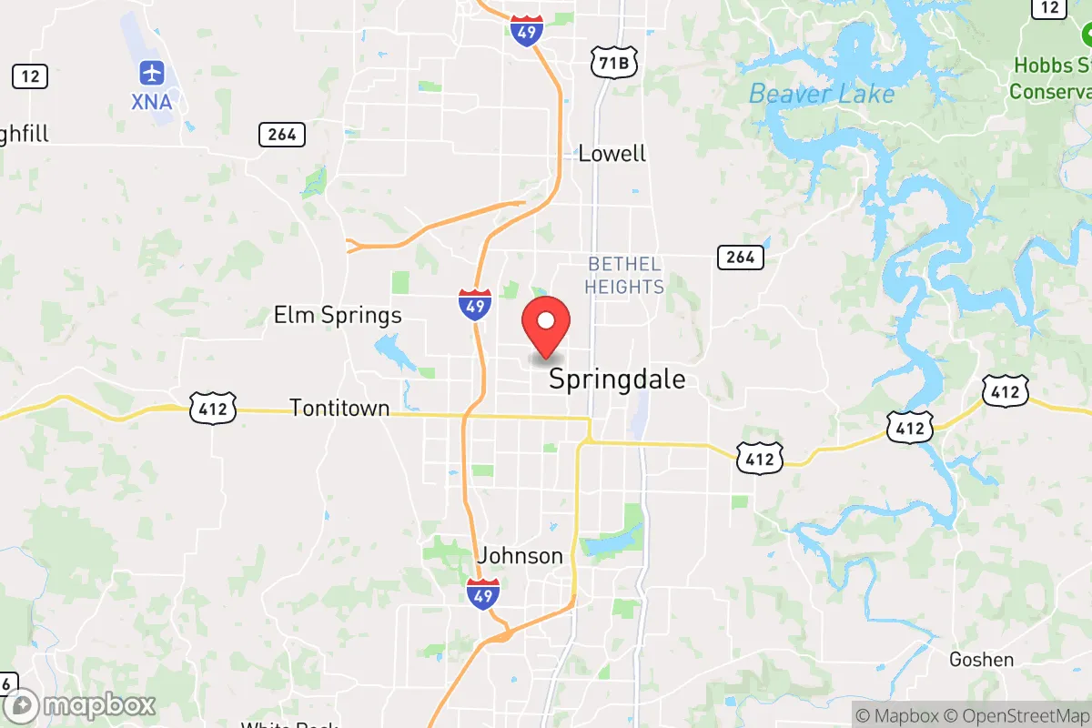
Springdale, Arkansas, sits in a geographic sweet spot that offers genuine strategic depth for those serious about resilience, but it’s not without its own set of vulnerabilities. Nestled in the northwest corner of the state, this city benefits from being far enough from the nation’s most obvious target zones—think D.C., New York, or the West Coast ports—while still maintaining access to critical infrastructure and supply chains. For a relocator with a prepper mindset, the area’s combination of agricultural abundance, water resources, and a growing but not overcrowded population makes it a serious contender for a long-term base of operations, provided you understand where the risks actually lie.
Geographic position and natural advantages for long-term security
Springdale’s location in the Ozark foothills is its first and most important asset. The terrain is rolling and wooded, offering natural cover and defensible positions that flatland areas simply cannot match. The city sits within the Arkansas River Valley watershed, meaning access to surface water is reliable, and the underlying geology includes the Ozark aquifer, one of the most productive freshwater sources in the region. For a prepper, this means you’re not dependent on a single municipal supply—wells are viable, and many rural properties already have them. The climate is temperate, with four distinct seasons but no extreme weather patterns that would force mass evacuations; tornadoes are a real threat, but the area is not in the heart of Tornado Alley, and the hills provide some natural windbreak. Critically, Springdale is about 300 miles from the nearest major metropolitan target—Dallas-Fort Worth—and over 400 miles from the St. Louis or Memphis urban centers. That distance buys you time and reduces the likelihood of fallout or refugee flow from a major event. The region’s agricultural output is another hidden advantage: Northwest Arkansas is a hub for poultry and cattle production, with Tyson Foods headquartered right in Springdale. In a prolonged disruption, local food supply chains would likely hold up better here than in most of the country.
Risks, exposures, and proximity to fallout-relevant landmarks
No analysis is honest without addressing the downsides, and Springdale has a few that demand attention. The most obvious is its proximity to the John A. White Dam (also known as Beaver Dam) on the White River, about 30 miles east. While the dam is well-maintained, a catastrophic failure—whether from seismic activity, sabotage, or simple age—would send a wall of water down the valley that could inundate low-lying parts of Springdale and the surrounding area. The city’s floodplain maps show significant risk zones near the river, so any property search should prioritize elevation above the 100-year flood line. Second, the region is home to the Arkansas Nuclear One plant near Russellville, about 70 miles southeast. That’s close enough that a major release could affect air and water quality in Springdale, especially if prevailing winds shift. For a prepper, this means having a radiation detection kit and a plan for sheltering in place or moving north into Missouri if the worst happens. Third, Springdale’s growth has been rapid—the metro area population has nearly doubled since 2000—which means infrastructure is strained. The city’s water treatment plants and power grid are modern but not hardened against EMP or sustained cyberattacks. Finally, the area’s economic reliance on a single industry (poultry and logistics) creates a vulnerability: if Tyson’s operations are disrupted, the local economy could crater quickly, leading to civil unrest that a smaller community might absorb better.
Practical resilience for a relocator: food, water, energy, and defensibility
For someone looking to set up a resilient homestead or smallholding, Springdale offers a mix of advantages and trade-offs. Water is the strongest suit: the Ozark aquifer is deep and clean, and many rural properties have access to springs or creeks. Rainwater collection is also viable, with annual precipitation averaging around 45 inches. Food production is realistic: the growing season runs from April to October, and the soil in the river bottoms is rich loam, though the hillsides are more rocky and better suited for orchards or livestock than row crops. Local farmers’ markets are abundant, and the presence of Tyson means that even in a crisis, there’s likely to be a local supply of poultry and meat—though you’ll want to establish relationships with small-scale producers now, not when things go sideways. Energy independence is achievable: the area has decent solar potential, with about 200 sunny days per year, and the wooded terrain means firewood is plentiful for backup heating. However, the local grid is managed by Ozarks Electric Cooperative, which has a mixed track record on reliability during ice storms. A generator or battery bank is non-negotiable. Defensibility is moderate: the hills and hollows provide natural chokepoints, but Springdale itself is a sprawling suburban environment with few natural barriers. The real value is in the outlying areas—places like Elm Springs, Tontitown, or the rural stretches of Washington County—where you can have acreage, a well, and a clear line of sight. The local gun culture is strong, and law enforcement is generally supportive of Second Amendment rights, which matters if you’re serious about self-defense. The county sheriff’s office is well-funded and responsive, but in a widespread collapse, you’ll be relying on your own network, not 911.
The overall strategic picture for Springdale is one of cautious optimism for the prepared relocator. It’s not a bug-out location in the wilderness—it’s a working city with real infrastructure, real jobs, and real exposure to the same systemic risks that plague the rest of the country. But its geographic isolation from primary targets, its agricultural base, and its water abundance give it a resilience profile that most urban areas lack. The key is to treat Springdale as a base of operations, not a final redoubt. Buy land on high ground, dig a well, store food, and build relationships with the local farming community. If you do that, you’ll be in a position to weather most storms—economic, social, or otherwise—better than 90% of the country. Just don’t ignore the dam, the nuke plant, or the fact that the city’s growth is bringing more people who aren’t prepared. That’s your edge, and it’s worth acting on now.
* Values derived from national, state, county, city and local statistics and may differ in a specific area. Last updated: 2026-04-29T19:14:58.000Z
Narrative content on this page is AI-generated and may contain mistakes. Verify any details that matter before acting on them.
ReloMaps may earn a commission from affiliate links at no extra cost to you.