Photo: Wikipedia
Strategic Assessment of Summerset, SD
Workable tactical position. Some exposure to population density or targets, but generally defensible in a crisis.
What does the Strategic Assessment tell us?
Our Strategic Assessment grades tactical survivability of an area. Major population centers, military targets, fallout zones, natural disasters, and border exposure all drive risk — lower exposure means a more defensible position in a crisis.
This is heavily inspired by Joel Skousen's Strategic Relocation book. Highly recommended you checkout the book ($)What does this tell us?
Our Strategic Assessment grades tactical survivability of an area. Major population centers, military targets, fallout zones, natural disasters, and border exposure all drive risk — lower exposure means a more defensible position in a crisis.
This is heavily inspired by Joel Skousen's Strategic Relocation book. Highly recommended you checkout the book ($)Strategic Pillars

Key Distances
Regional Safe Places
Below is our recommended "safe zones" in South Dakota and the surrounding area based on our strategic heuristics. For most people, it's unrealistic to live in a “safe zone” full-time due to work, family or other personal reasons. They tend to be more rural. However, many of these areas are perfect for second homes and retreat properties that double as a vacation home or even a short-term rental.


Important Note: For informational purposes only. This does not mean nothing bad ever happens in the green zones. Please use common sense. This is based on public data and modeled with AI. We tried to take a conservative approach but mistakes happen. We update this regularly as new information becomes available.
Solar Generator Recommendations
Backup power matters more here than in safer locations. We've picked three solar generators across budgets and capacity tiers — start with the budget unit if you only need a few essentials, or step up if you want to run a fridge and HVAC for days at a time.

Jackery Portable Power Station Explorer 300
Budget OptionPower on the Go: Weighing only 11 lbs, it's convenient to set up and store with book-sized foldable solar panels

BLUETTI Portable Power Station AC180
Designed for both indoor and outdoor scenarios, AC180 is highly capable as it has a robost capacity and continuous output power.

EF ECOFLOW DELTA Pro Ultra Power Station
Upgraded PickEcoFlow DELTA Pro Ultra is a whole-home energy system designed to grow with your family. Integrated with the Smart Home Panel 2, it scales to meet your evolving energy needs — keeping your home powered, intelligent, and secure through every stage of life.
We earn a commission, at no additional cost to you.
Strategic Assessment Analysis
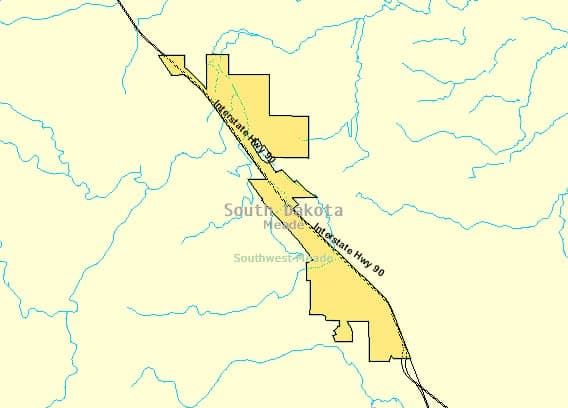
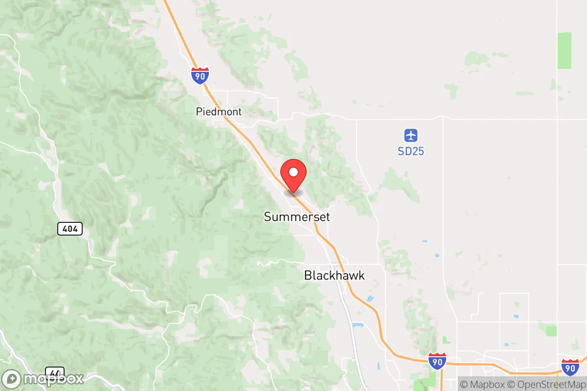
Summerset, South Dakota, offers a compelling strategic position for those prioritizing resilience and self-sufficiency, sitting just far enough from the Black Hills' tourist corridors to avoid the worst of disruption while remaining within reach of essential resources. Its location on the western edge of the state, roughly 15 miles northwest of Rapid City, places it in a low-density corridor that is unlikely to be a primary target in a national crisis, yet it retains access to the region's agricultural and water assets. For a conservative-leaning relocator concerned with civic unrest, mass casualty events, or supply chain collapse, Summerset represents a middle ground—not a remote bunker, but a defensible community with a realistic shot at weathering extended disruptions.
Geographic position and natural advantages for long-term survival
Summerset sits at the eastern edge of the Black Hills, a region defined by its elevation, forest cover, and abundant groundwater. The area's natural advantages begin with water: the Black Hills aquifer system provides reliable, deep groundwater that is less vulnerable to surface contamination than the shallow aquifers of the Plains. Summerset itself is near Rapid Creek, which flows year-round and feeds into Pactola Reservoir, a 1,200-acre body of water roughly 10 miles west. In a grid-down scenario, this reservoir offers a primary water source that could be gravity-fed or hand-pumped to surrounding areas. The surrounding terrain—rolling hills with mixed pine and hardwood—provides natural cover and defensible positions, while the higher elevation (3,200–3,500 feet) reduces the risk of flooding and keeps summer temperatures moderate. Winters are cold, with average January lows around 12°F, but the region's low humidity and consistent snowfall mean that meltwater is a predictable seasonal resource. For a relocator, the key takeaway is that Summerset's geography offers multiple independent water sources, forest resources for fuel and construction, and a climate that, while harsh, is survivable with proper preparation.
Risks, exposures, and proximity to fallout-relevant landmarks
The primary risk for Summerset is its proximity to Rapid City, a population center of roughly 75,000 that would become a focal point for civil unrest, resource competition, and potential secondary effects from a major disaster. Rapid City is also home to Ellsworth Air Force Base, a B-1B Lancer bomber base that would be a high-priority target in a nuclear exchange. While Summerset is 15 miles northwest of the base—outside the likely blast radius for a single warhead—the fallout plume from a ground burst at Ellsworth would depend on wind direction. Prevailing winds in the region are from the west and northwest, meaning that a strike on the base would push fallout east and southeast, away from Summerset. However, a strike on the base or on the Minuteman III silos scattered across western South Dakota (the 44th Missile Wing at Malmstrom AFB covers this area) could produce unpredictable fallout patterns. The nearest missile silos are roughly 60 miles east, near Wall, SD, placing Summerset outside the immediate danger zone but within the broader risk envelope. Other risks include wildfire—the 2021 Legion Lake Fire burned 54,000 acres in the Black Hills, and Summerset's forested edges are vulnerable—and winter storms that can isolate the area for days. The strategic assessment here is that Summerset's risks are manageable with preparation: fallout is a real but probabilistic concern, and the area's distance from major infrastructure targets (no dams, no nuclear plants, no major rail hubs) reduces the likelihood of cascading failures.
Practical resilience for a relocator: food, water, energy, and defensibility
For a relocator focused on practical self-sufficiency, Summerset offers a workable baseline. Water is the strongest asset: most homes in the area rely on private wells drawing from the Madison Aquifer, which produces high-quality water at depths of 200–400 feet. Hand pumps or solar-powered pumps can maintain access during grid failure. The Rapid Creek watershed provides surface water for filtration, though treatment would be necessary. Food production is limited by the short growing season (roughly 120 frost-free days) and sandy, rocky soils, but the region's cattle ranching and hay production mean that local food networks exist. The Black Hills Farmers Market in Rapid City (summer months) and the surrounding ranchlands offer sources for seed stock, livestock, and barter goods. For a relocator, establishing a greenhouse or high-tunnel system is essential for year-round vegetable production. Energy is a mixed picture: grid power is reliable in normal times, but the area's wind and solar potential is excellent. Average wind speeds at 80 meters are 7–8 m/s, and solar insolation is 5.0–5.5 kWh/m²/day, making off-grid systems viable. Wood heating is common, with ample deadfall and firewood available from the Black Hills National Forest (with proper permits). Defensibility is moderate: Summerset's layout is a mix of suburban subdivisions and rural acreages, with limited choke points on the main access roads (Highway 44 and Highway 79). The terrain offers good line-of-sight for perimeter monitoring, but the area's growing population (up 40% since 2010) means that a full-scale collapse would bring pressure from Rapid City evacuees. A relocator should prioritize a property with a well, south-facing solar exposure, and at least 5–10 acres for buffer and food production.
The overall strategic picture for Summerset is that of a viable but not ideal relocation node for a conservative prepper. Its strengths—water abundance, low target value, forest resources, and a conservative-leaning local culture (Pennington County voted +16 R in 2024)—are real. Its weaknesses—proximity to a military base, a growing population, and a short growing season—require honest assessment and mitigation. For a single individual or family willing to invest in off-grid infrastructure, maintain a low profile, and build relationships with the local ranching community, Summerset offers a defensible position with a realistic path to long-term survival. It is not a remote retreat, but it is a place where preparation and community can make the difference between merely surviving and actually thriving in a disrupted world.
* Values derived from national, state, county, city and local statistics and may differ in a specific area. Last updated: 2026-04-23T09:18:04.000Z
Narrative content on this page is AI-generated and may contain mistakes. Verify any details that matter before acting on them.
ReloMaps may earn a commission from affiliate links at no extra cost to you.