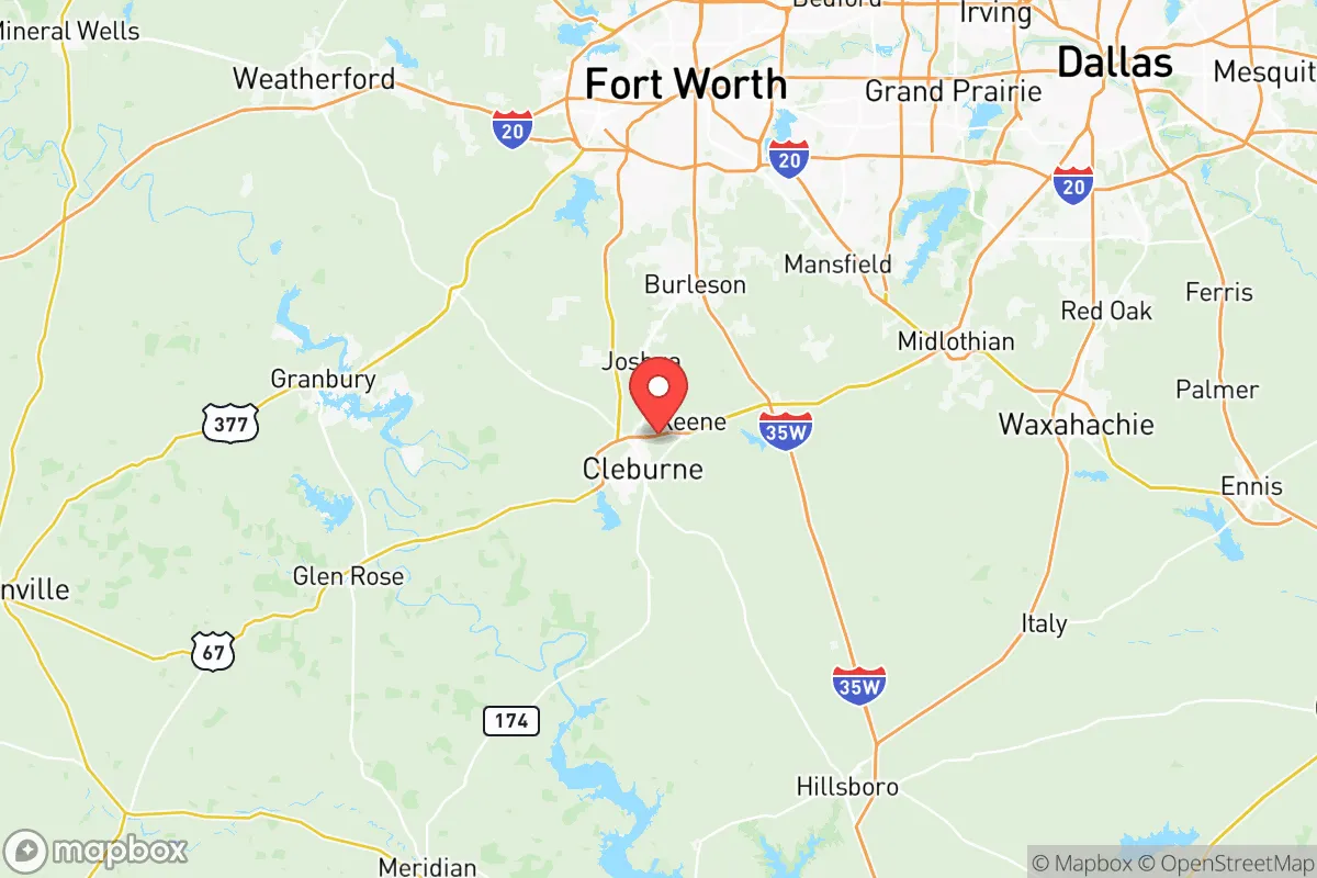
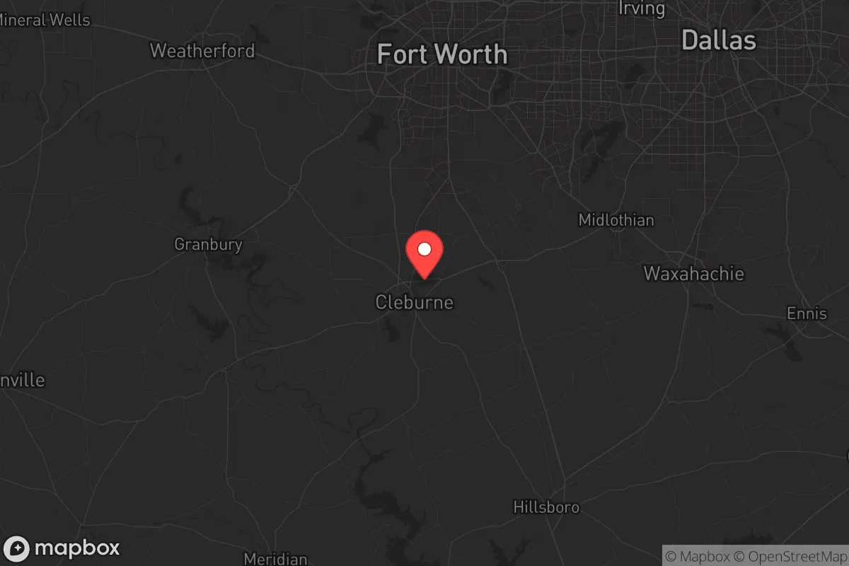
Strategic Assessment of Johnson County
Meaningful friction. Expect exposure to either population pressure, blast zones, or natural disaster risk. Consider buying a retreat property.
What does the Strategic Assessment tell us?
Our Strategic Assessment grades tactical survivability of an area. Major population centers, military targets, fallout zones, natural disasters, and border exposure all drive risk — lower exposure means a more defensible position in a crisis.
This is heavily inspired by Joel Skousen's Strategic Relocation book. Highly recommended you checkout the book ($)What does this tell us?
Our Strategic Assessment grades tactical survivability of an area. Major population centers, military targets, fallout zones, natural disasters, and border exposure all drive risk — lower exposure means a more defensible position in a crisis.
This is heavily inspired by Joel Skousen's Strategic Relocation book. Highly recommended you checkout the book ($)Strategic Pillars

Key Distances
Strategic Assessment Analysis
Johnson County, Texas, sits in a sweet spot that resilience-minded relocators should take seriously: close enough to the Dallas-Fort Worth metroplex to access its resources, but far enough to avoid the blast radius, civil unrest, and supply-chain choke points that plague urban cores. The county’s population hovers around 180,000, with Cleburne as the seat and largest city, but the real draw is the rural buffer—ranches, farmland, and small towns like Burleson, Alvarado, and Grandview that offer a quieter, more defensible base. For a conservative-leaning individual or family looking to weather economic instability, natural disasters, or societal breakdown, Johnson County provides a strategic mix of agricultural self-sufficiency, low population density, and proximity to critical infrastructure without being on top of it.
Geographic position and natural advantages for long-term stability
Johnson County’s location is its strongest card. It sits southwest of the Dallas-Fort Worth metroplex, roughly 30 miles from downtown Fort Worth, which means you can tap into major medical centers, supply hubs, and employment corridors—like the I-35W and US-67 corridors—without living in a target-rich environment. The county is part of the Cross Timbers region, a transitional zone between the Blackland Prairie and the Grand Prairie, offering a mix of rolling hills, oak woodlands, and fertile soil. This isn’t flat, exposed farmland; the terrain provides natural cover and defensible positions, especially around the Brazos River and its tributaries like the Nolan River and Mustang Creek. Water access is a major plus: the Brazos River runs through the county’s western edge, and Lake Pat Cleburne near Cleburne offers a reliable freshwater source for drinking, irrigation, and emergency supply. The climate is temperate, with hot summers and mild winters, reducing the risk of extreme weather events like hurricanes or blizzards that plague other regions. Tornadoes are a seasonal concern, but the county’s topography and building codes mitigate worst-case scenarios—unlike coastal zones that face annual hurricane threats. For a prepper, this means fewer natural disasters to plan around and more time to focus on human-caused risks.
Risks, exposures, and proximity to fallout-relevant landmarks
No location is perfect, and Johnson County has its share of vulnerabilities. The biggest risk is proximity to the Dallas-Fort Worth metroplex, a major economic and population center that would be a prime target for civil unrest, terrorist attacks, or even a nuclear strike. The county sits within 50 miles of Fort Worth’s Naval Air Station Joint Reserve Base and Dallas Love Field, both potential military targets. Additionally, the Bureau of Engraving and Printing’s Fort Worth facility—where U.S. currency is printed—is a high-value landmark that could draw attention in a collapse scenario. On the industrial side, Johnson County is near the Port of Dallas and major rail yards, but it’s not directly adjacent to the Houston Ship Channel or the Texas Gulf Coast refinery corridor, which are massive fallout magnets. That’s a net positive. The county itself has no nuclear plants, major chemical refineries, or military bases within its borders, reducing the risk of direct strikes or industrial accidents. However, the I-35W corridor is a critical north-south artery that could become a chokepoint during evacuations or supply disruptions. If the grid goes down or fuel supplies are cut, that highway becomes a liability—think stranded vehicles, looters, and refugee flows from the cities. The county’s rural nature helps, but relocators should plan for secondary routes and off-grid travel.
Practical resilience for a relocator: food, water, energy, and defensibility
Johnson County is a strong candidate for self-sufficiency. The agricultural base is solid: cattle ranching, hay production, and row crops like corn and wheat are common, meaning local food sources are available even if supply chains collapse. Cleburne’s farmers’ market and local co-ops provide a network for barter and trade, and the county’s soil quality supports home gardening—especially in the eastern half near Burleson and Grandview. Water is the critical resource, and Johnson County has it in spades. Lake Pat Cleburne is a 1,500-acre reservoir that supplies the city of Cleburne and surrounding areas, but rural properties often have private wells, which are a major advantage over municipal systems that could fail during a crisis. The Brazos River is a perennial water source, though access points are limited by private land ownership—something to verify before buying. For energy, the county is part of the ERCOT grid, which has proven unreliable during winter storms (think 2021’s Winter Storm Uri). Solar panels and battery storage are a smart investment here, as the region gets over 200 sunny days per year. Propane generators and wood-burning stoves are also practical, given the rural landscape and availability of firewood. Defensibility is mixed: the county’s open farmland offers long sightlines but limited cover, while the wooded areas near the Brazos and Nolan Rivers provide natural concealment. Burleson and Alvarado are more suburban and harder to defend than a remote ranch near Grandview, but they offer community networks and mutual aid potential. The key is to avoid floodplains and low-lying areas near creeks, which could become impassable during heavy rains. Overall, a relocator with a well on a few acres in the western part of the county has a strong hand for long-term survival.
The strategic picture for Johnson County is one of calculated trade-offs. It’s not a remote bunker in the mountains—it’s a working-class, conservative-leaning area with a mix of rural and suburban communities that offer a balance of access and isolation. The risks from the Dallas-Fort Worth metroplex are real, but they’re manageable with proper planning: stockpiling supplies, establishing off-grid water and power, and building relationships with neighbors who share your values. The county’s agricultural base, water resources, and lack of high-value targets make it a better bet than areas closer to Houston, San Antonio, or the coast. For a family or individual looking to relocate with a prepper mindset, Johnson County deserves a serious look—just don’t expect a fortress. Expect a place where you can build one, if you’re willing to put in the work.
* Values derived from national, state, county, city and local statistics and may differ in a specific area. Last updated: 2026-05-09T13:27:31.000Z
Narrative content on this page is AI-generated and may contain mistakes. Verify any details that matter before acting on them.
ReloMaps may earn a commission from affiliate links at no extra cost to you.