
Photo: Wikipedia
Strategic Assessment of The Dalles, OR
Workable tactical position. Some exposure to population density or targets, but generally defensible in a crisis.
What does the Strategic Assessment tell us?
Our Strategic Assessment grades tactical survivability of an area. Major population centers, military targets, fallout zones, natural disasters, and border exposure all drive risk — lower exposure means a more defensible position in a crisis.
This is heavily inspired by Joel Skousen's Strategic Relocation book. Highly recommended you checkout the book ($)What does this tell us?
Our Strategic Assessment grades tactical survivability of an area. Major population centers, military targets, fallout zones, natural disasters, and border exposure all drive risk — lower exposure means a more defensible position in a crisis.
This is heavily inspired by Joel Skousen's Strategic Relocation book. Highly recommended you checkout the book ($)Strategic Pillars

Key Distances
Regional Safe Places
Below is our recommended "safe zones" in Oregon and the surrounding area based on our strategic heuristics. For most people, it's unrealistic to live in a “safe zone” full-time due to work, family or other personal reasons. They tend to be more rural. However, many of these areas are perfect for second homes and retreat properties that double as a vacation home or even a short-term rental.


Important Note: For informational purposes only. This does not mean nothing bad ever happens in the green zones. Please use common sense. This is based on public data and modeled with AI. We tried to take a conservative approach but mistakes happen. We update this regularly as new information becomes available.
Solar Generator Recommendations
Backup power matters more here than in safer locations. We've picked three solar generators across budgets and capacity tiers — start with the budget unit if you only need a few essentials, or step up if you want to run a fridge and HVAC for days at a time.

Jackery Portable Power Station Explorer 300
Budget OptionPower on the Go: Weighing only 11 lbs, it's convenient to set up and store with book-sized foldable solar panels

BLUETTI Portable Power Station AC180
Designed for both indoor and outdoor scenarios, AC180 is highly capable as it has a robost capacity and continuous output power.

EF ECOFLOW DELTA Pro Ultra Power Station
Upgraded PickEcoFlow DELTA Pro Ultra is a whole-home energy system designed to grow with your family. Integrated with the Smart Home Panel 2, it scales to meet your evolving energy needs — keeping your home powered, intelligent, and secure through every stage of life.
We earn a commission, at no additional cost to you.
Strategic Assessment Analysis
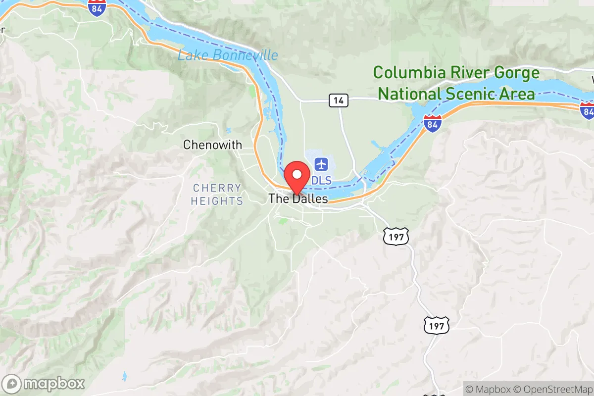
The Dalles, Oregon, occupies a strategic position along the Columbia River Gorge that offers a rare combination of geographic isolation and critical infrastructure access—making it a serious contender for those prioritizing long-term resilience. Located roughly 80 miles east of Portland, this community of roughly 16,000 sits at the intersection of Interstate 84 and U.S. Route 197, placing it far enough from major urban centers to avoid the worst of a collapse scenario while remaining close enough to supply chains and transport corridors if they hold. The area’s historical role as a transportation hub, its hydroelectric backbone, and its agricultural potential give it a baseline survivability that many rural towns lack, but the assessment requires a hard look at both the natural advantages and the very real exposure risks that come with being in a gorge that funnels people, freight, and potential threats.
Geographic position and natural advantages for long-term survival
The Dalles sits in a rain shadow created by the Cascade Range, receiving only about 14 inches of precipitation annually—a stark contrast to Portland’s 36 inches. This drier climate reduces mold, rot, and infrastructure degradation, which matters for anyone stockpiling supplies or maintaining off-grid systems. The Columbia River provides an immense, reliable freshwater source, and the surrounding basalt cliffs offer natural defensibility; the town is essentially nestled in a narrow valley with high ground on both sides, making approach routes limited and observable. The area’s elevation at roughly 100 feet above sea level keeps it above most flood risks, and the volcanic soils of the surrounding Wasco County are productive for dryland wheat and grazing, meaning local food production is viable without heavy irrigation. For a relocator, the ability to tap into the Columbia for water, the relatively mild winters (average January low of 28°F), and the low population density of the surrounding county (about 26 people per square mile) create a baseline that beats most of the Willamette Valley for self-sufficiency. The nearby Mount Hood National Forest and the Deschutes National Forest to the south provide timber, game, and additional buffer zones, though access requires navigating Forest Service roads that can become impassable in winter.
Risks, exposures, and proximity to fallout-relevant landmarks
The Dalles is not a fallout-free zone, and anyone serious about prepping needs to understand the specific threats. The most immediate concern is the Columbia River Gorge itself—a natural funnel for wind, wildfire, and human traffic. The 2017 Eagle Creek Fire burned over 48,000 acres and came within a few miles of town, and the gorge’s wind patterns (average 10-15 mph, with gusts over 50 mph in spring) can drive fire or airborne contaminants rapidly. The town sits directly under the flight path for Portland International Airport’s approach routes, and while that’s not a direct threat, it means the area is a potential target for any scenario involving airspace disruption. More critically, The Dalles is 20 miles upstream from the John Day Dam and 25 miles downstream from The Dalles Dam—both major hydroelectric facilities that are part of the Federal Columbia River Power System. In a grid-down or conflict scenario, these dams become high-value targets; a breach or sabotage would send a catastrophic flood wave through the gorge, though the town’s elevation on the south bank provides some buffer. The town is also 70 miles from the Hanford Nuclear Reservation in Washington, a decommissioned plutonium production site with massive underground waste tanks. While prevailing winds blow east-to-west, a major release from Hanford could contaminate the Columbia River watershed, directly impacting The Dalles’ water supply. For the conservative prepper, the proximity to Portland (80 miles) means that any urban collapse—civil unrest, disease outbreak, or supply chain failure—will send refugees east along I-84, and The Dalles is the first substantial town they’ll hit. The Wasco County Sheriff’s Office has roughly 30 sworn deputies for a county of 26,000, so law enforcement capacity is thin for any large-scale event.
Practical resilience for a relocator: food, water, energy, and defensibility
Water is the strongest asset here. The Columbia River is a massive, year-round source, and the city’s municipal water system draws directly from it, with treatment capacity that could be maintained with backup power. For off-grid setups, wells in the area typically hit groundwater at 50-200 feet, and the basalt aquifers are reliable. Food production is viable but not effortless: the growing season runs roughly April to October, and the dry climate requires irrigation for most vegetables, but the surrounding wheat and cattle operations mean bulk grains and protein are available locally if markets hold. The Dalles is home to the Oregon Veterans Home and a sizable agricultural workforce, so there’s a base of people with practical skills. Energy resilience is strong—the town is served by the The Dalles Dam, which generates over 1,800 megawatts, and the local utility (Northern Wasco County PUD) has a history of maintaining service through storms. For off-grid setups, solar is viable here: the area averages 300 sunny days per year, and the low humidity means panels stay efficient. Defensibility is mixed. The town’s layout along the river and the interstate makes it hard to seal off completely, but the surrounding hills and the fact that only two major roads (I-84 and US-197) lead in give residents the ability to monitor and control access points. The local gun culture is strong—Oregon is a shall-issue state for concealed carry, and Wasco County has a high per-capita firearm ownership rate—so there’s a baseline of armed preparedness among the population. The biggest practical weakness is medical infrastructure: the local hospital, Mid-Columbia Medical Center, is a 49-bed critical access facility with limited trauma capability. A serious injury or illness would require a 90-minute transport to Portland, which in a crisis could be a death sentence.
The overall strategic picture for The Dalles is one of high potential paired with specific, manageable vulnerabilities. It’s not a remote bunker—it’s a working town with a real economy, real people, and real exposure to the same national trends that worry the prepper community. But for a relocator who wants to be within striking distance of the Pacific Northwest’s resources without being inside the blast radius of a major city, it’s one of the better options in Oregon. The water, the energy, the agricultural base, and the defensible geography give it a resilience score that beats most of the Willamette Valley and the coastal towns. The downsides—the dam risk, the Hanford shadow, the refugee corridor—are real but manageable with proper planning: a well-stocked retreat on the south side of town, away from I-84, with a gravity-fed water system and a good radio setup, would cover most of the exposure. The Dalles isn’t a paradise, but in a world where the grid could flicker and the cities could burn, it’s a place where a prepared individual or family could hold ground and ride out the worst.
* Values derived from national, state, county, city and local statistics and may differ in a specific area. Last updated: 2026-04-20T19:12:14.000Z
Narrative content on this page is AI-generated and may contain mistakes. Verify any details that matter before acting on them.
ReloMaps may earn a commission from affiliate links at no extra cost to you.