Photo: Wikipedia
Strategic Assessment of Tupelo, MS
Workable tactical position. Some exposure to population density or targets, but generally defensible in a crisis.
What does the Strategic Assessment tell us?
Our Strategic Assessment grades tactical survivability of an area. Major population centers, military targets, fallout zones, natural disasters, and border exposure all drive risk — lower exposure means a more defensible position in a crisis.
This is heavily inspired by Joel Skousen's Strategic Relocation book. Highly recommended you checkout the book ($)What does this tell us?
Our Strategic Assessment grades tactical survivability of an area. Major population centers, military targets, fallout zones, natural disasters, and border exposure all drive risk — lower exposure means a more defensible position in a crisis.
This is heavily inspired by Joel Skousen's Strategic Relocation book. Highly recommended you checkout the book ($)Strategic Pillars

Key Distances
Regional Safe Places
Below is our recommended "safe zones" in Mississippi and the surrounding area based on our strategic heuristics. For most people, it's unrealistic to live in a “safe zone” full-time due to work, family or other personal reasons. They tend to be more rural. However, many of these areas are perfect for second homes and retreat properties that double as a vacation home or even a short-term rental.
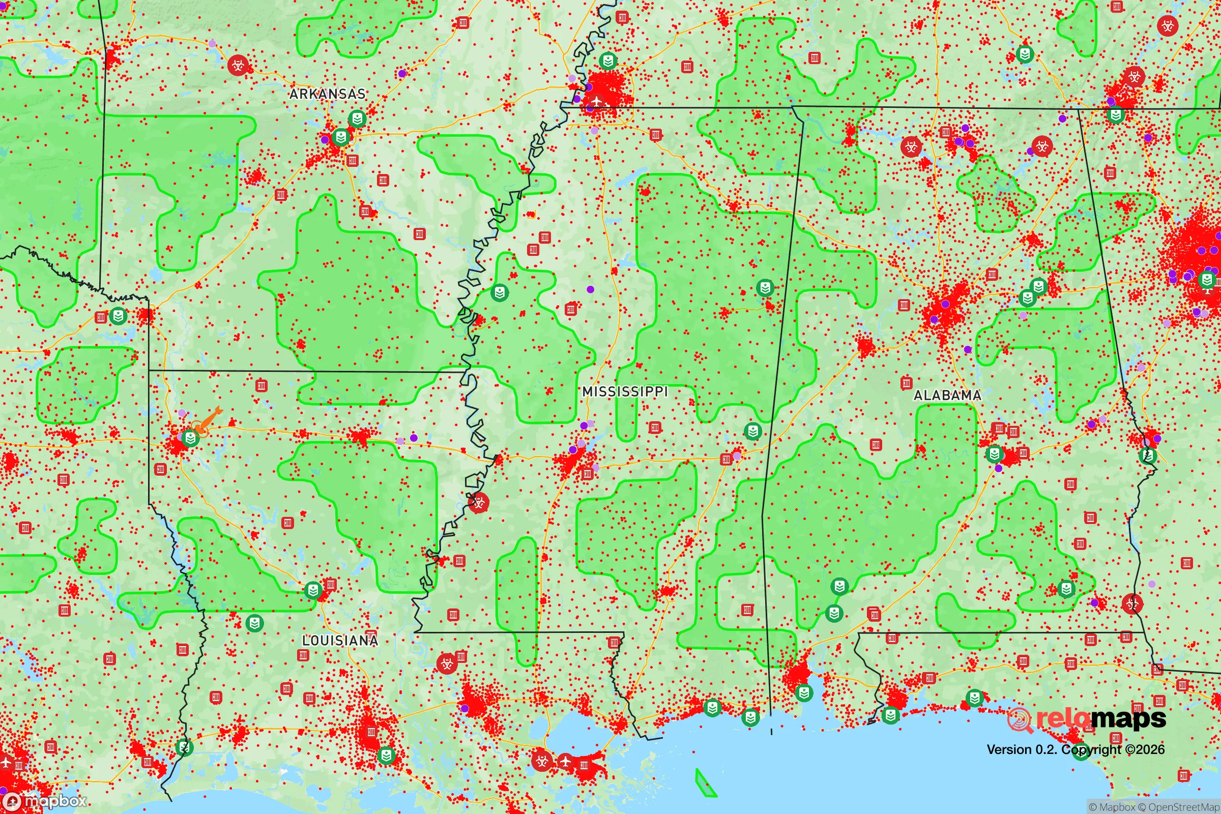
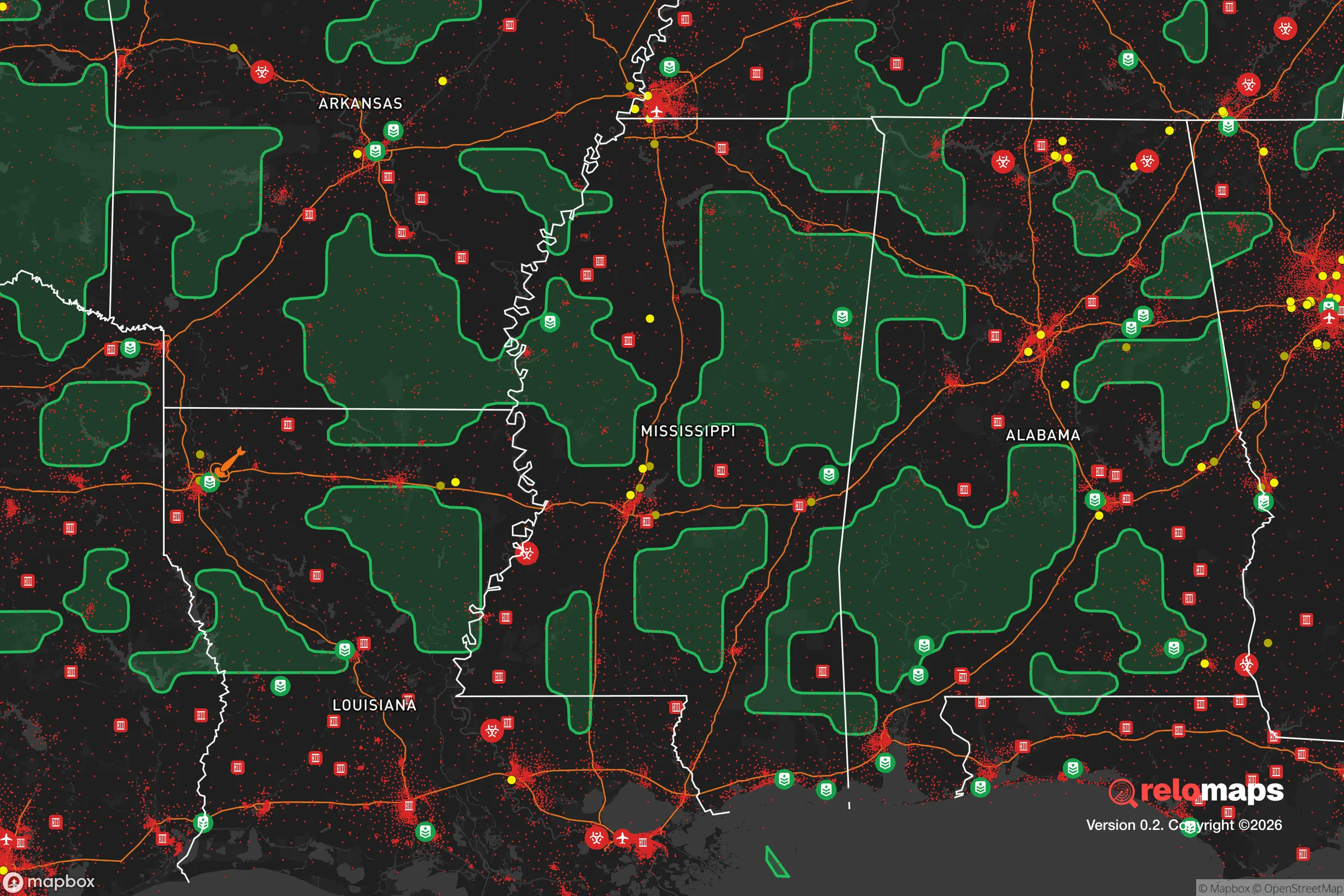
Important Note: For informational purposes only. This does not mean nothing bad ever happens in the green zones. Please use common sense. This is based on public data and modeled with AI. We tried to take a conservative approach but mistakes happen. We update this regularly as new information becomes available.
Solar Generator Recommendations
Backup power matters more here than in safer locations. We've picked three solar generators across budgets and capacity tiers — start with the budget unit if you only need a few essentials, or step up if you want to run a fridge and HVAC for days at a time.

Jackery Portable Power Station Explorer 300
Budget OptionPower on the Go: Weighing only 11 lbs, it's convenient to set up and store with book-sized foldable solar panels

BLUETTI Portable Power Station AC180
Designed for both indoor and outdoor scenarios, AC180 is highly capable as it has a robost capacity and continuous output power.

EF ECOFLOW DELTA Pro Ultra Power Station
Upgraded PickEcoFlow DELTA Pro Ultra is a whole-home energy system designed to grow with your family. Integrated with the Smart Home Panel 2, it scales to meet your evolving energy needs — keeping your home powered, intelligent, and secure through every stage of life.
We earn a commission, at no additional cost to you.
Strategic Assessment Analysis
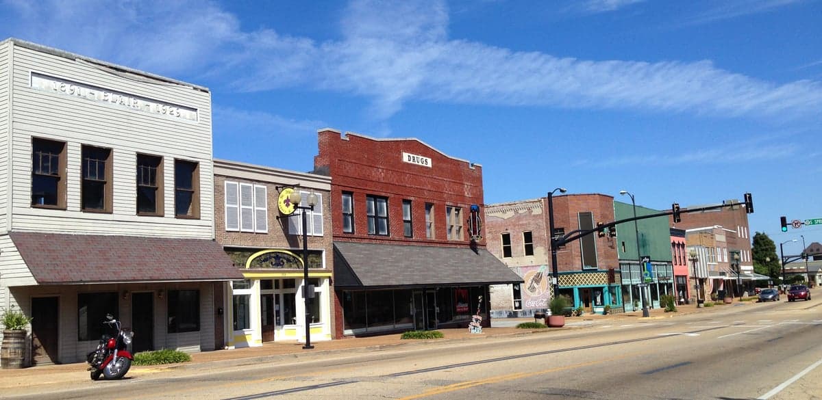
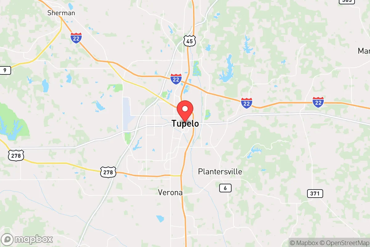
Tupelo, Mississippi, sits in a geographic sweet spot that combines genuine resilience advantages with the kind of overlooked stability that strategic relocators value. Located in the northeastern hill country of Mississippi, roughly 100 miles southeast of Memphis and 150 miles northeast of Jackson, Tupelo avoids the direct blast zones and immediate fallout risks of major metropolitan areas while remaining within a practical distance for supply runs or medical access if needed. The city’s economic foundation—anchored by manufacturing, healthcare, and a diversified small-business base—has proven durable through national downturns, and its position away from coastal hurricane landfalls and major fault lines gives it a natural buffer against the most common large-scale natural disasters. For someone thinking in terms of decades rather than election cycles, Tupelo offers a low-profile, high-functioning base of operations.
Geographic position and natural advantages for long-term security
Tupelo’s location in the Tennessee-Tombigbee Waterway corridor provides a strategic transportation advantage that most small Southern cities lack. The city sits near the intersection of U.S. Highway 78 (soon to be Interstate 22) and the Natchez Trace Parkway, giving residents two redundant road networks for evacuation or resupply if one route becomes compromised. The surrounding landscape is rolling hills and mixed hardwood forest, not flat delta farmland—this means better drainage, fewer flood risks, and more natural cover for those concerned about aerial surveillance or unwanted attention during breakdown scenarios. The area’s geology is stable; there are no active fault lines within 200 miles, and the region’s highest recorded earthquake intensity is barely perceptible. Tornado risk is real but manageable—northeast Mississippi sits in the traditional Dixie Alley, but Tupelo’s specific topography breaks up storm cells more effectively than the open plains to the west. The local water table is high and reliable, with the Tennessee River system less than 30 miles east, providing a year-round freshwater source that doesn’t depend on municipal infrastructure.
Risks, exposures, and proximity to fallout-relevant landmarks
The primary risk for Tupelo is its proximity to Memphis, which sits 100 miles to the northwest. Memphis is a major transportation hub with a large port on the Mississippi River, a FedEx SuperHub, and a significant population density—all of which make it a potential target for civil unrest, infrastructure sabotage, or, in a worst-case scenario, a nuclear strike. Fallout from a Memphis event would depend heavily on wind patterns; prevailing winds in the region blow from the south and southwest, meaning Tupelo would be downwind of Memphis roughly 30-40% of the time, depending on the season. The city itself has no major military installations, no nuclear power plants within 50 miles, and no obvious high-value industrial targets. The nearest nuclear facility is the Browns Ferry Nuclear Plant in Alabama, about 90 miles east-southeast—close enough to be a concern if something goes wrong, but far enough that a direct strike on it would not directly threaten Tupelo. The Tennessee Valley Authority’s transmission lines run through the area, which could make the region a secondary target in a coordinated attack on the power grid, but that risk applies to most of the Southeast. On balance, Tupelo’s risk profile is low compared to cities near D.C., New York, or Los Angeles, but it is not zero—and the Memphis factor is the one to watch.
Practical resilience for a relocator: food, water, energy, and defensibility
For someone serious about self-sufficiency, Tupelo’s practical assets are strong. The surrounding Lee County and adjacent Itawamba, Pontotoc, and Union counties are agricultural areas with active farming operations—row crops, cattle, poultry, and timber. This means local food production is not theoretical; it is happening right now, and a relocator with land can tap into existing networks for seed stock, livestock, and equipment. The local climate supports a 7-8 month growing season, and the soil in the hill country is loamy and well-drained, suitable for gardens, orchards, and small-scale grain production. Water access is straightforward: the water table is shallow enough that a driven well (sand point) can be installed by hand in many areas, and deeper drilled wells are affordable compared to Western states. The Tennessee-Tombigbee Waterway and numerous creeks and ponds provide surface water for non-potable uses. Energy resilience is more challenging but workable. The local grid is served by the Tennessee Valley Authority, which has a strong reliability record, but a prepper should plan for solar with battery backup—the region gets about 215 sunny days per year, which is adequate for a modest off-grid system. Wood heating is practical, as hardwood is abundant and cheap. Defensibility is where Tupelo shines for a relocator: the city itself is compact and walkable in the core, but the surrounding rural areas offer properties with natural chokepoints, tree cover, and distance from main roads. The local culture is heavily armed and self-reliant—Mississippi has some of the most permissive firearm laws in the country, and the local population is overwhelmingly supportive of the Second Amendment. Law enforcement presence is adequate but not oppressive; the Lee County Sheriff’s Office and Tupelo Police Department are professional but understaffed relative to the area, meaning that in a crisis, residents are expected to handle their own security.
The overall strategic picture for Tupelo is one of quiet competence. It is not a flashy relocation destination, and it does not offer the dramatic natural defenses of mountain redoubts in Idaho or West Virginia. What it offers is something arguably more valuable for the long haul: a functioning small city with a real economy, a stable water supply, arable land, and a population that is culturally aligned with self-reliance and mutual aid. The Memphis risk is real but manageable with proper planning—good filtration, a fallout shelter if budget allows, and a pre-planned evacuation route east toward the Appalachians if things go hot. For the conservative relocator who wants to be prepared without living in a bunker, Tupelo represents a balanced option: low cost of living, low visibility, and high practical resilience. It is a place where you can build a life that is both normal and prepared, without the paranoia of a full-time prepper compound or the vulnerability of a dense urban center. If the country holds together, you have a solid community and a reasonable cost of living. If it does not, you have a defensible position with resources and neighbors who will not hesitate to defend what is theirs. That is the kind of hedge that makes strategic sense.
* Values derived from national, state, county, city and local statistics and may differ in a specific area. Last updated: 2026-04-19T05:39:01.000Z
Narrative content on this page is AI-generated and may contain mistakes. Verify any details that matter before acting on them.
ReloMaps may earn a commission from affiliate links at no extra cost to you.