Photo: Wikipedia
Strategic Assessment of Warrensburg, MO
Workable tactical position. Some exposure to population density or targets, but generally defensible in a crisis.
What does the Strategic Assessment tell us?
Our Strategic Assessment grades tactical survivability of an area. Major population centers, military targets, fallout zones, natural disasters, and border exposure all drive risk — lower exposure means a more defensible position in a crisis.
This is heavily inspired by Joel Skousen's Strategic Relocation book. Highly recommended you checkout the book ($)What does this tell us?
Our Strategic Assessment grades tactical survivability of an area. Major population centers, military targets, fallout zones, natural disasters, and border exposure all drive risk — lower exposure means a more defensible position in a crisis.
This is heavily inspired by Joel Skousen's Strategic Relocation book. Highly recommended you checkout the book ($)Strategic Pillars

Key Distances
Regional Safe Places
Below is our recommended "safe zones" in Missouri and the surrounding area based on our strategic heuristics. For most people, it's unrealistic to live in a “safe zone” full-time due to work, family or other personal reasons. They tend to be more rural. However, many of these areas are perfect for second homes and retreat properties that double as a vacation home or even a short-term rental.


Important Note: For informational purposes only. This does not mean nothing bad ever happens in the green zones. Please use common sense. This is based on public data and modeled with AI. We tried to take a conservative approach but mistakes happen. We update this regularly as new information becomes available.
Solar Generator Recommendations
Backup power matters more here than in safer locations. We've picked three solar generators across budgets and capacity tiers — start with the budget unit if you only need a few essentials, or step up if you want to run a fridge and HVAC for days at a time.

Jackery Portable Power Station Explorer 300
Budget OptionPower on the Go: Weighing only 11 lbs, it's convenient to set up and store with book-sized foldable solar panels

BLUETTI Portable Power Station AC180
Designed for both indoor and outdoor scenarios, AC180 is highly capable as it has a robost capacity and continuous output power.

EF ECOFLOW DELTA Pro Ultra Power Station
Upgraded PickEcoFlow DELTA Pro Ultra is a whole-home energy system designed to grow with your family. Integrated with the Smart Home Panel 2, it scales to meet your evolving energy needs — keeping your home powered, intelligent, and secure through every stage of life.
We earn a commission, at no additional cost to you.
Strategic Assessment Analysis
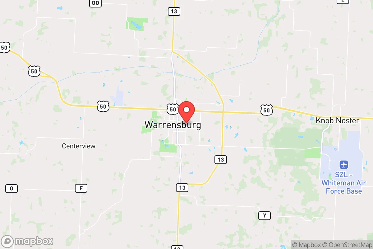
Warrensburg, Missouri, sits in a sweet spot for those serious about strategic relocation: close enough to Kansas City’s resources to be useful, but far enough — roughly 50 miles southeast — to avoid the blast radius, fallout plume, and post-collapse chaos of a major metropolitan target. The city’s position along the I-70 corridor and near the Missouri River gives it both logistical advantages and exposure risks, but for a prepper or survivalist looking for a defensible, resource-rich base with a conservative, self-reliant culture, Warrensburg offers a compelling mix of isolation and access. The local economy is anchored by the University of Central Missouri and Whiteman Air Force Base, which means a steady influx of government and education dollars, but also a population that’s accustomed to structure and discipline — traits that matter when things go sideways.
Geographic position and natural advantages for long-term survival
Warrensburg’s geography is its strongest card. It sits on the edge of the Osage Plains, a region of rolling hills, limestone bluffs, and fertile river bottoms that offer good drainage, decent soil for small-scale agriculture, and plenty of natural cover. The area is not in a major floodplain — unlike much of the Missouri River valley — so catastrophic flooding is rare. The climate is continental, with hot summers and cold winters, but it’s not extreme enough to make off-grid living impossible; you can grow a garden from April through October, and the local deer and turkey populations are healthy enough to supplement protein. Water access is the real prize: the nearby Blackwater River and several smaller creeks provide surface water, and the region sits atop the Ozark Aquifer, meaning well water is generally reliable and of good quality. For a relocator, that means you’re not dependent on municipal supply lines that could fail in a crisis. The surrounding countryside is a patchwork of small farms, woodlots, and pastureland, which gives you options for buying a few acres without drawing attention. The area’s low population density — Johnson County has about 54,000 people spread over 833 square miles — means you’re not competing with a million neighbors for the same resources when the grid goes down.
Risks, exposures, and proximity to fallout-relevant landmarks
No strategic assessment is honest without naming the threats. Warrensburg’s biggest liability is its proximity to Whiteman Air Force Base, home to the B-2 Spirit stealth bomber and the 509th Bomb Wing. That makes it a high-value target in any conflict involving strategic nuclear forces. The base is about 15 miles east of downtown Warrensburg, which puts the city inside the moderate damage zone for a ground burst on the base — think broken windows, overturned cars, and a heavy fallout plume drifting downwind. If you’re within 20 miles of a nuclear target, you’re in the zone where fallout becomes a life-or-death calculation. The prevailing winds in Missouri blow from the west and southwest, so a strike on Whiteman would push fallout toward Sedalia and the Lake of the Ozarks, not directly over Warrensburg — but that’s cold comfort if the wind shifts. Beyond nukes, the I-70 corridor is a double-edged sword: it’s a major evacuation route out of Kansas City, which means in a crisis, you’ll see a wave of refugees moving through town, potentially bringing disease, desperation, and violence. The city itself has a small police force and no real natural barriers to slow an influx. The Missouri River, about 20 miles north, is a potential contamination vector if upstream industrial sites or nuclear plants (like the Callaway Plant near Fulton) are compromised. For the serious prepper, these risks mean you need a plan for bugging in with good filtration and a secure perimeter, or a secondary retreat further south or west.
Practical resilience for a relocator: food, water, energy, and defensibility
Warrensburg’s practical resilience is a mixed bag, but the positives outweigh the negatives for someone willing to put in the work. Food security is solid: the area is surrounded by row-crop agriculture (corn, soybeans, wheat) and livestock operations, so barter and local sourcing are viable. The Warrensburg Farmers Market runs seasonally, and there are several local butchers and co-ops that could become supply nodes in a partial collapse. For the home grower, the growing season is about 180 days, and the soil is workable with amendments. Water is the stronger suit: as noted, well water is common, and the Blackwater River and its tributaries are perennial. A hand pump or solar-powered well setup would keep you hydrated even without grid power. Energy is where the area falls short: the local grid is served by Evergy, a regional utility that’s had reliability issues during ice storms and heat waves. Solar is viable — the area gets about 200 sunny days per year — but you’ll need battery storage and a backup generator for winter cloud cover. Wood heating is an option, as hardwood forests are within a 30-minute drive, but you’ll need a chainsaw and a truck. Defensibility depends on your exact property. The city itself is flat and open, with a typical Midwestern grid layout that’s hard to secure. But the rural outskirts — especially south and east of town toward the Knob Noster State Park area — offer rolling terrain, tree lines, and limited road access that make a homestead easier to defend. The local gun culture is strong, with several gun shops and ranges in the county, and Missouri is a constitutional carry state, so legal barriers to self-defense are minimal. The community is generally friendly but not nosy; people keep to themselves, which is ideal for a low-profile setup.
The overall strategic picture for Warrensburg is one of calculated trade-offs. It’s not a remote mountain redoubt, and it’s not a fortified compound in the desert. It’s a working-class Midwestern town with a conservative, self-sufficient ethos, decent natural resources, and a location that gives you options — but only if you’re honest about the risks. The Whiteman AFB target is the elephant in the room; if you’re worried about nuclear war, you need to be at least 50 miles from any military installation, and Warrensburg doesn’t clear that bar. But for the more likely scenarios — civil unrest, economic collapse, supply chain disruptions, a pandemic sequel — the area’s agricultural base, water access, and low population density make it a strong choice. The key is to buy land outside the city limits, invest in well water and solar, and build relationships with local farmers and tradesmen before you need them. Warrensburg won’t save you from a direct hit, but it will give you a fighting chance in the long, slow unraveling that many preppers see as the real threat. If you’re looking for a base that balances access to civilization with genuine survival capability, this area deserves a serious look — just keep your bug-out bag packed and your eyes on the wind.
* Values derived from national, state, county, city and local statistics and may differ in a specific area. Last updated: 2026-04-29T21:00:24.000Z
Narrative content on this page is AI-generated and may contain mistakes. Verify any details that matter before acting on them.
ReloMaps may earn a commission from affiliate links at no extra cost to you.