Photo: Wikipedia
Strategic Assessment of Weiser, ID
Deep buffer from population centers and strategic targets. Low natural disaster risk and minimal exposure to border or coastal threats.
What does the Strategic Assessment tell us?
Our Strategic Assessment grades tactical survivability of an area. Major population centers, military targets, fallout zones, natural disasters, and border exposure all drive risk — lower exposure means a more defensible position in a crisis.
This is heavily inspired by Joel Skousen's Strategic Relocation book. Highly recommended you checkout the book ($)What does this tell us?
Our Strategic Assessment grades tactical survivability of an area. Major population centers, military targets, fallout zones, natural disasters, and border exposure all drive risk — lower exposure means a more defensible position in a crisis.
This is heavily inspired by Joel Skousen's Strategic Relocation book. Highly recommended you checkout the book ($)Strategic Pillars

Key Distances
Regional Safe Places
Below is our recommended "safe zones" in Idaho and the surrounding area based on our strategic heuristics. For most people, it's unrealistic to live in a “safe zone” full-time due to work, family or other personal reasons. They tend to be more rural. However, many of these areas are perfect for second homes and retreat properties that double as a vacation home or even a short-term rental.


Important Note: For informational purposes only. This does not mean nothing bad ever happens in the green zones. Please use common sense. This is based on public data and modeled with AI. We tried to take a conservative approach but mistakes happen. We update this regularly as new information becomes available.
Solar Generator Recommendations
Backup power matters more here than in safer locations. We've picked three solar generators across budgets and capacity tiers — start with the budget unit if you only need a few essentials, or step up if you want to run a fridge and HVAC for days at a time.

Jackery Portable Power Station Explorer 300
Budget OptionPower on the Go: Weighing only 11 lbs, it's convenient to set up and store with book-sized foldable solar panels

BLUETTI Portable Power Station AC180
Designed for both indoor and outdoor scenarios, AC180 is highly capable as it has a robost capacity and continuous output power.

EF ECOFLOW DELTA Pro Ultra Power Station
Upgraded PickEcoFlow DELTA Pro Ultra is a whole-home energy system designed to grow with your family. Integrated with the Smart Home Panel 2, it scales to meet your evolving energy needs — keeping your home powered, intelligent, and secure through every stage of life.
We earn a commission, at no additional cost to you.
Strategic Assessment Analysis
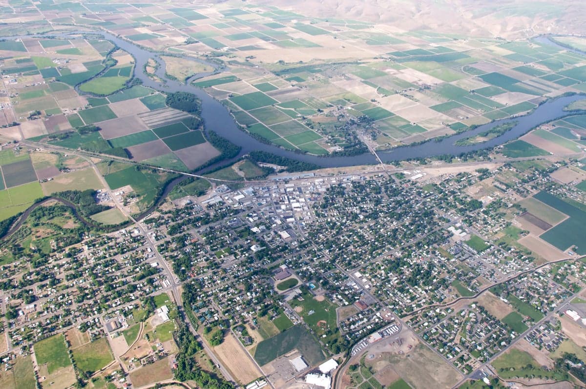
Weiser, Idaho, sits in a strategic pocket that offers genuine resilience advantages for those thinking long-term about security and self-sufficiency. Tucked into the western edge of the state along the Snake River, this town of roughly 5,500 people benefits from being far enough from major population centers to avoid the worst of cascading collapse scenarios, yet close enough to regional infrastructure to make relocation practical. The area’s agricultural base, water access, and low population density create a foundation that preppers and survivalists should take seriously, especially when compared to the increasingly fragile urban corridors of the West Coast or Front Range.
Geographic position and natural advantages for long-term security
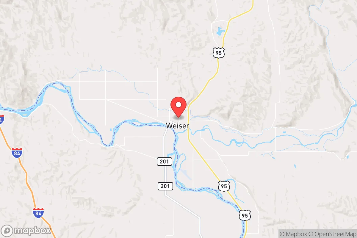
Weiser’s location at the confluence of the Weiser River and the Snake River is its single most important strategic asset. The Snake River watershed provides a reliable, year-round water source that doesn’t depend on fragile municipal pumping systems or distant aquifers. The surrounding terrain is a mix of irrigated farmland, rolling hills, and sagebrush steppe, offering multiple avenues for food production and defensive positioning. The town sits in a valley that is sheltered from the worst winter weather by the nearby mountains, meaning heating fuel demands are lower than in the high Rockies or northern plains. The area is also far from any major seismic zones, nuclear power plants, or large military installations that could become fallout targets. The nearest city of any real size is Boise, about 70 miles southeast — close enough for supply runs in normal times, but far enough that a collapse or evacuation of Boise would not immediately overwhelm Weiser. The Oregon border is just across the river, which adds a layer of jurisdictional complexity that could be useful in a crisis scenario. For a relocator, the key takeaway is that this is not a place that will be on anyone’s first list of targets, and the natural resource base is strong enough to support a reduced population through a prolonged disruption.
Risks, exposures, and proximity to fallout-relevant landmarks
No location is without vulnerabilities, and Weiser has a few that a serious prepper needs to account for. The most obvious risk is the town’s proximity to the Snake River Plain and the Idaho National Laboratory (INL), about 150 miles to the east. While that distance provides a significant buffer, INL is a major nuclear research and waste facility, and a catastrophic event there — whether from accident, sabotage, or wartime targeting — could produce a fallout plume that reaches western Idaho depending on wind patterns. The prevailing winds in the region are from the southwest, which somewhat mitigates this risk, but it is not zero. Additionally, Weiser lies within a reasonable driving distance of Interstate 84, the main east-west corridor through southern Idaho. In a mass evacuation scenario from Boise or the Treasure Valley, that highway could become a chokepoint funneling desperate people toward smaller towns. Weiser itself is not directly on I-84, but it is close enough that secondary roads could see heavy traffic. The town’s economy is heavily agricultural, which is a strength in normal times but means that a prolonged drought or disruption to irrigation infrastructure (much of which depends on electricity for pumping) could stress local food production. There are no major military bases or command centers nearby, which is actually a positive from a targeting perspective, but it also means that federal disaster response resources would be slow to arrive in a crisis. For a relocator, the calculus is that Weiser’s risks are manageable and largely natural or logistical, not the kind of immediate man-made threats that plague suburbs near major cities.
Practical resilience for a relocator: food, water, energy, and defensibility
For someone serious about self-reliance, Weiser offers a realistic path to practical resilience. Water is the non-negotiable first layer, and the Snake River provides an almost inexhaustible surface supply. Groundwater in the valley is also accessible at reasonable depths, and many rural properties already have wells. The agricultural character of the area means that soil quality is good for growing vegetables, grains, and forage, and the growing season is long enough (about 150 frost-free days) to produce a meaningful food surplus. Local farmers and ranchers are a tight-knit community, and in a crisis, barter networks based on food and labor would likely form quickly. Energy is a mixed picture: the grid is relatively stable compared to coastal areas, but winter ice storms can knock out power for days. Solar is viable here, with over 200 sunny days per year, but battery storage is essential because winter days are short. Wood heating is common in the surrounding rural areas, and the nearby Payette National Forest provides a substantial fuel source for those with the means to harvest it. Defensibility is where Weiser shines. The town is compact, with a clear perimeter defined by the river and agricultural fields. The population is small enough that a community defense plan is feasible, and the local culture is heavily oriented toward hunting, firearms ownership, and outdoor skills. The county sheriff’s office is small but professional, and in a prolonged breakdown, the existing social fabric would likely hold better than in a more transient or urban area. For a relocator, the practical steps are clear: secure a property with water rights or well access, invest in solar and wood heat, build relationships with local growers, and store at least a year’s worth of supplies to bridge the gap until local production can be scaled up.
The overall strategic picture for Weiser is that it represents a solid B+ option for someone looking to relocate with a prepper mindset. It is not the most remote or defensible location in the Intermountain West — places like central Idaho or the Montana Rockies offer more isolation and harder terrain — but it compensates with superior water access, a more moderate climate, and a functional local economy that does not depend entirely on tourism or government spending. The trade-off is that you are close enough to Boise and the I-84 corridor to feel the ripple effects of a regional collapse, but far enough that you have time to react. For a conservative-leaning individual or family who values community, self-sufficiency, and a lower risk profile than the coasts or the Front Range, Weiser deserves a serious look. The key is to move before the next crisis drives prices up and availability down — because once the urban evacuees start looking at maps, places like this will not stay quiet for long.
* Values derived from national, state, county, city and local statistics and may differ in a specific area. Last updated: 2026-05-03T20:23:15.000Z
Narrative content on this page is AI-generated and may contain mistakes. Verify any details that matter before acting on them.
ReloMaps may earn a commission from affiliate links at no extra cost to you.