
Photo: Wikipedia
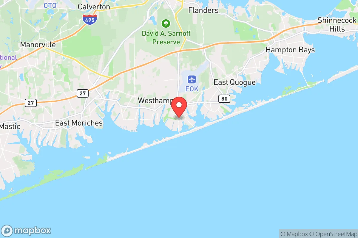
Strategic Assessment of Westhampton Beach, NY
Multiple tactical vulnerabilities. Population density, target proximity, or disaster risk are likely compounding. A retreat property and exit planning is required.
What does the Strategic Assessment tell us?
Our Strategic Assessment grades tactical survivability of an area. Major population centers, military targets, fallout zones, natural disasters, and border exposure all drive risk — lower exposure means a more defensible position in a crisis.
This is heavily inspired by Joel Skousen's Strategic Relocation book. Highly recommended you checkout the book ($)What does this tell us?
Our Strategic Assessment grades tactical survivability of an area. Major population centers, military targets, fallout zones, natural disasters, and border exposure all drive risk — lower exposure means a more defensible position in a crisis.
This is heavily inspired by Joel Skousen's Strategic Relocation book. Highly recommended you checkout the book ($)Strategic Pillars

Key Distances
Regional Safe Places
Below is our recommended "safe zones" in New York and the surrounding area based on our strategic heuristics. For most people, it's unrealistic to live in a “safe zone” full-time due to work, family or other personal reasons. They tend to be more rural. However, many of these areas are perfect for second homes and retreat properties that double as a vacation home or even a short-term rental.


Important Note: For informational purposes only. This does not mean nothing bad ever happens in the green zones. Please use common sense. This is based on public data and modeled with AI. We tried to take a conservative approach but mistakes happen. We update this regularly as new information becomes available.
Solar Generator Recommendations
Backup power matters more here than in safer locations. We've picked three solar generators across budgets and capacity tiers — start with the budget unit if you only need a few essentials, or step up if you want to run a fridge and HVAC for days at a time.

Jackery Portable Power Station Explorer 300
Budget OptionPower on the Go: Weighing only 11 lbs, it's convenient to set up and store with book-sized foldable solar panels

BLUETTI Portable Power Station AC180
Designed for both indoor and outdoor scenarios, AC180 is highly capable as it has a robost capacity and continuous output power.

EF ECOFLOW DELTA Pro Ultra Power Station
Upgraded PickEcoFlow DELTA Pro Ultra is a whole-home energy system designed to grow with your family. Integrated with the Smart Home Panel 2, it scales to meet your evolving energy needs — keeping your home powered, intelligent, and secure through every stage of life.
We earn a commission, at no additional cost to you.
Strategic Assessment Analysis
Westhampton Beach, New York, presents a complex strategic picture for the conservative prepper or survivalist. Its primary advantage is geographic insulation: situated on the South Fork of Long Island, roughly 75 miles east of Manhattan, it sits at the far end of a narrow, easily chokepointed peninsula. This location offers a degree of natural buffer from the immediate chaos of a major metropolitan collapse, but that same geography creates a one-way funnel that could become a trap. For the relocator prioritizing resilience, Westhampton Beach is a study in trade-offs—strong on natural resources and community cohesion, but dangerously exposed to coastal threats and logistical isolation.
Geographic position and natural advantages for long-term survival
Westhampton Beach’s position on the barrier island system of the South Fork provides distinct natural advantages. The area is surrounded by the Atlantic Ocean to the south and Moriches Bay to the north, offering abundant marine life—fish, shellfish, and waterfowl—that could sustain a skilled forager. The nearby Pine Barrens, a vast 100,000-acre protected forest, supplies firewood, game like deer and turkey, and wild edibles. The region’s groundwater aquifer is generally high-quality, though saltwater intrusion is a growing concern. For the prepper, these resources mean a lower reliance on supply chains for basic calories and water, at least in the short term. The local climate supports a long growing season for vegetables, and many existing residents maintain gardens or small farms, creating a potential barter network. The community’s wealth—median home values exceed $1.5 million—also means that infrastructure like roads, septic systems, and emergency services are well-maintained compared to rural upstate areas. However, this wealth cuts both ways: a collapse could trigger rapid resource hoarding and social stratification among the affluent population.
Risks, exposures, and proximity to fallout-relevant landmarks
The downsides are severe and demand honest assessment. Westhampton Beach’s primary vulnerability is its location on a barrier island, which is inherently unstable. A Category 3 or higher hurricane could inundate the entire area with storm surge, destroying homes, contaminating freshwater supplies, and making evacuation impossible for days. The 1938 Long Island Express hurricane, which killed over 50 people on the South Fork, is a historical precedent. Beyond weather, the area’s proximity to New York City—just a 90-minute drive in normal traffic—is a double-edged sword. In a mass casualty event or civil unrest scenario, Westhampton Beach would be a prime destination for fleeing urbanites, overwhelming local resources. The nearby Brookhaven National Laboratory, 20 miles west, is a nuclear research facility with radiological materials; a terrorist attack or accident there could render the entire South Fork uninhabitable for years. Additionally, the Shinnecock Inlet, just east of the village, is a strategic maritime chokepoint that could become contested in a breakdown of order. The area’s reliance on the Long Island Rail Road and a single major highway (Sunrise Highway/Route 27) for resupply means that any disruption—whether from a storm, a cyberattack, or civil unrest—would sever the lifeline to the mainland.
Practical resilience for a relocator: food, water, energy, and defensibility
For the individual or family looking to establish a resilient outpost, Westhampton Beach offers a mixed bag. Food security is moderate: local farms like the 40-acre Fairview Farm at Mecox grow vegetables and raise livestock, but they are not scaled for a population of 2,000 year-round residents plus seasonal crowds. The Atlantic and bay provide protein, but fishing requires gear and knowledge, and competition would spike in a crisis. Water is a critical concern: most homes rely on private wells drawing from the Upper Glacial Aquifer, which is generally clean but vulnerable to saltwater intrusion and surface contamination. A backup hand pump or rainwater catchment system is essential. Energy independence is achievable: the area has strong solar potential, with over 200 sunny days per year, and many homes already have solar panels. However, the grid is fragile and prone to outages from nor’easters and hurricanes; a generator with a 500-gallon propane tank is a wise investment. Defensibility is the weakest link: the barrier island’s flat, open terrain offers little natural cover, and the single road in and out (Route 27) is a choke point that could be blocked by a single accident or checkpoint. The local police department is small (roughly 25 officers) and would be overwhelmed in a widespread event. For a relocator, the best strategy is to establish a small, self-sufficient homestead on the mainland side of the Shinnecock Canal—areas like Quiogue or Eastport offer better defensibility with access to the same natural resources. If you must be on the beach, focus on a property with a deep well, solar array, and a boat capable of navigating the bay and ocean for alternative routes.
The overall strategic picture for Westhampton Beach is one of calculated risk. It is not a bug-out location for the unprepared—the seasonal population swells to 10,000 in summer, and the area’s affluence means that resources are priced for the wealthy. For the disciplined prepper with capital and a plan, it offers a rare combination of natural abundance and community infrastructure that could sustain a small group through a moderate disruption. But for a long-term collapse scenario involving nuclear fallout, prolonged civil unrest, or climate-driven sea-level rise, the risks of coastal isolation and single-point-of-failure logistics outweigh the benefits. The conservative relocator should view Westhampton Beach as a temporary haven—a place to ride out the first 6-12 months of a crisis while monitoring conditions for a secondary move inland to the Appalachian foothills. If you choose this area, invest in maritime skills, stockpile 90 days of supplies minimum, and build relationships with local farmers and fishermen before the storm hits. The Hamptons may look like paradise, but in a broken world, paradise is often the first place to be looted.
* Values derived from national, state, county, city and local statistics and may differ in a specific area. Last updated: 2026-04-24T01:48:21.000Z
Narrative content on this page is AI-generated and may contain mistakes. Verify any details that matter before acting on them.
ReloMaps may earn a commission from affiliate links at no extra cost to you.