Photo: Wikipedia
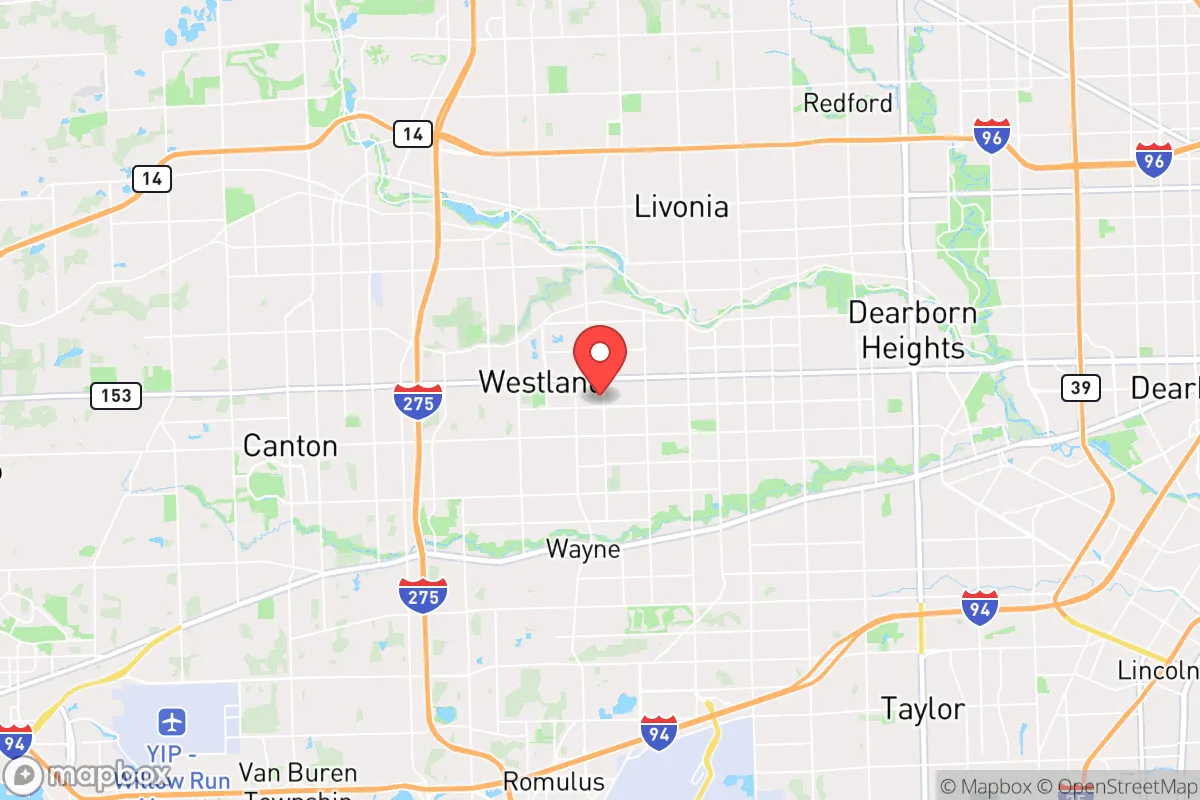
Strategic Assessment of Westland, MI
Multiple tactical vulnerabilities. Population density, target proximity, or disaster risk are likely compounding. A retreat property and exit planning is required.
What does the Strategic Assessment tell us?
Our Strategic Assessment grades tactical survivability of an area. Major population centers, military targets, fallout zones, natural disasters, and border exposure all drive risk — lower exposure means a more defensible position in a crisis.
This is heavily inspired by Joel Skousen's Strategic Relocation book. Highly recommended you checkout the book ($)What does this tell us?
Our Strategic Assessment grades tactical survivability of an area. Major population centers, military targets, fallout zones, natural disasters, and border exposure all drive risk — lower exposure means a more defensible position in a crisis.
This is heavily inspired by Joel Skousen's Strategic Relocation book. Highly recommended you checkout the book ($)Strategic Pillars

Key Distances
Regional Safe Places
Below is our recommended "safe zones" in Michigan and the surrounding area based on our strategic heuristics. For most people, it's unrealistic to live in a “safe zone” full-time due to work, family or other personal reasons. They tend to be more rural. However, many of these areas are perfect for second homes and retreat properties that double as a vacation home or even a short-term rental.


Important Note: For informational purposes only. This does not mean nothing bad ever happens in the green zones. Please use common sense. This is based on public data and modeled with AI. We tried to take a conservative approach but mistakes happen. We update this regularly as new information becomes available.
Solar Generator Recommendations
Backup power matters more here than in safer locations. We've picked three solar generators across budgets and capacity tiers — start with the budget unit if you only need a few essentials, or step up if you want to run a fridge and HVAC for days at a time.

Jackery Portable Power Station Explorer 300
Budget OptionPower on the Go: Weighing only 11 lbs, it's convenient to set up and store with book-sized foldable solar panels

BLUETTI Portable Power Station AC180
Designed for both indoor and outdoor scenarios, AC180 is highly capable as it has a robost capacity and continuous output power.

EF ECOFLOW DELTA Pro Ultra Power Station
Upgraded PickEcoFlow DELTA Pro Ultra is a whole-home energy system designed to grow with your family. Integrated with the Smart Home Panel 2, it scales to meet your evolving energy needs — keeping your home powered, intelligent, and secure through every stage of life.
We earn a commission, at no additional cost to you.
Strategic Assessment Analysis
Westland, Michigan, presents a mixed bag for the strategic relocator. Its position in the western suburbs of Detroit offers some genuine resilience advantages—namely, a robust local economy and a relatively stable housing stock—but its proximity to a major metropolitan area and key industrial infrastructure introduces significant risk vectors that a prepper cannot ignore. The city’s location along the I-275 corridor and near the Detroit Metro Airport provides both logistical utility and a potential evacuation chokepoint, making it a location that demands careful, scenario-based planning rather than blind optimism.
Geographic position and natural advantages for a prepared household
Westland sits on the relatively flat, post-glacial terrain of Wayne County, about 20 miles west of downtown Detroit. Its primary natural advantage is access to fresh water. The city is within the Great Lakes watershed, and the Detroit River and Lake Erie are within a 30-minute drive. For a prepper, this means a potential secondary water source if municipal supplies are compromised, though you’ll need your own filtration and transport capability. The area’s climate is continental, with cold, snowy winters and warm, humid summers. This provides a natural barrier to year-round mobility for large, disorganized groups, but it also means you must be prepared for winter survival scenarios—power outages, frozen pipes, and road closures are annual realities. The soil in the region is mostly clay-based, which is poor for large-scale gardening without significant amendment, but the region’s agricultural history means there are still pockets of farmland within a 15-20 minute drive, particularly to the west in communities like Canton and Plymouth. For a relocator, the key takeaway is that Westland is not a remote bug-out location; it’s a suburban node with decent access to resources but also to the chaos of a major city.
Risks, exposures, and proximity to fallout-relevant landmarks
This is where Westland’s strategic picture darkens considerably. The city is within the immediate fallout zone of several high-value targets. Detroit Metro Airport (DTW), a major international hub and a likely military logistics point during a national emergency, is less than 10 miles south. The I-94 and I-275 interchange, a critical logistics artery, runs through the city’s southern edge. In a scenario involving a major terrorist attack, EMP, or conventional military strike, these are primary targets. Furthermore, Westland is roughly 25 miles from the Fermi 2 nuclear power plant in Monroe County. While the plant has a good safety record, a catastrophic failure or a deliberate attack would place Westland within the plume exposure pathway. The city’s population density—roughly 3,000 people per square mile—means that any large-scale evacuation would be a nightmare of gridlock, particularly on the limited east-west routes like Warren Road and Ford Road. For the conservative prepper, the calculus is clear: Westland offers the benefits of suburban infrastructure but at the cost of being within the blast radius of the very systems that make modern life possible. A relocator must have a plan for rapid departure or deep, sustained sheltering in place.
Practical resilience for a relocator: food, water, energy, and defensibility
For a single individual or family looking to establish a resilient household, Westland requires significant upfront investment. The city’s water supply comes from the Great Lakes Water Authority, which draws from the Detroit River. This system is vulnerable to contamination from upstream industrial sites or a coordinated attack. A prepper should assume that municipal water will be unsafe for at least 72 hours post-event. Installing a 55-gallon drum and a Berkey or similar gravity filter is non-negotiable here. Energy resilience is more promising. Westland is served by DTE Energy, which has a mixed reliability record, especially during summer storms and winter ice events. Solar panels are permitted, but the city’s zoning and HOA restrictions in some neighborhoods can be a hurdle. A whole-house generator, preferably running on propane or natural gas, is a wise investment. Food storage is straightforward: the city has multiple big-box stores (Meijer, Walmart, Kroger) within a 10-minute drive, but these will be stripped within hours of a crisis. Building a 3-6 month supply of shelf-stable food is the baseline for this location. Defensibility is the weakest point. Westland is a typical suburban grid of streets with few natural chokepoints. A single-family home on a quarter-acre lot offers limited standoff distance. The best defensive strategy here is not to fight but to be invisible—blend in, keep a low profile, and have a pre-planned route to a secondary location (a rural property in northern Michigan or Ohio) if the situation deteriorates beyond local control. The city’s police and fire services are professional but will be overwhelmed in a mass-casualty event. Medical self-sufficiency—a trauma kit, antibiotics, and basic surgical training—is a must.
The overall strategic picture for Westland is one of calculated risk. It is not a sanctuary, nor is it a death trap. For the conservative relocator who values proximity to employment and infrastructure but is willing to invest heavily in home hardening, water storage, and a robust evacuation plan, it can work. The key is to treat Westland as a base of operations, not a final redoubt. The city’s greatest strength—its integration into the regional economy—is also its greatest vulnerability. If you are looking for a place to ride out a long-term societal collapse, look further west or north. But if you need a location that offers a decent quality of life now, with the potential for resilience if you put in the work, Westland is a viable, if demanding, option. The bottom line: know your neighbors, stock your pantry, and always have a full tank of gas.
* Values derived from national, state, county, city and local statistics and may differ in a specific area. Last updated: 2026-04-29T17:49:07.000Z
Narrative content on this page is AI-generated and may contain mistakes. Verify any details that matter before acting on them.
ReloMaps may earn a commission from affiliate links at no extra cost to you.