Photo: John Holm via Unsplash
Strategic Assessment of Barre, VT
Meaningful friction. Expect exposure to either population pressure, blast zones, or natural disaster risk. Consider buying a retreat property.
What does the Strategic Assessment tell us?
Our Strategic Assessment grades tactical survivability of an area. Major population centers, military targets, fallout zones, natural disasters, and border exposure all drive risk — lower exposure means a more defensible position in a crisis.
This is heavily inspired by Joel Skousen's Strategic Relocation book. Highly recommended you checkout the book ($)What does this tell us?
Our Strategic Assessment grades tactical survivability of an area. Major population centers, military targets, fallout zones, natural disasters, and border exposure all drive risk — lower exposure means a more defensible position in a crisis.
This is heavily inspired by Joel Skousen's Strategic Relocation book. Highly recommended you checkout the book ($)Strategic Pillars

Key Distances
Regional Safe Places
Below is our recommended "safe zones" in Vermont and the surrounding area based on our strategic heuristics. For most people, it's unrealistic to live in a “safe zone” full-time due to work, family or other personal reasons. They tend to be more rural. However, many of these areas are perfect for second homes and retreat properties that double as a vacation home or even a short-term rental.


Important Note: For informational purposes only. This does not mean nothing bad ever happens in the green zones. Please use common sense. This is based on public data and modeled with AI. We tried to take a conservative approach but mistakes happen. We update this regularly as new information becomes available.
Solar Generator Recommendations
Backup power matters more here than in safer locations. We've picked three solar generators across budgets and capacity tiers — start with the budget unit if you only need a few essentials, or step up if you want to run a fridge and HVAC for days at a time.

Jackery Portable Power Station Explorer 300
Budget OptionPower on the Go: Weighing only 11 lbs, it's convenient to set up and store with book-sized foldable solar panels

BLUETTI Portable Power Station AC180
Designed for both indoor and outdoor scenarios, AC180 is highly capable as it has a robost capacity and continuous output power.

EF ECOFLOW DELTA Pro Ultra Power Station
Upgraded PickEcoFlow DELTA Pro Ultra is a whole-home energy system designed to grow with your family. Integrated with the Smart Home Panel 2, it scales to meet your evolving energy needs — keeping your home powered, intelligent, and secure through every stage of life.
We earn a commission, at no additional cost to you.
Strategic Assessment Analysis
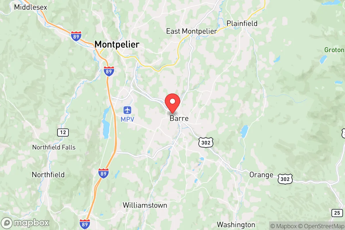
Barre, Vermont, often overlooked in favor of its more famous neighbor Montpelier, presents a surprisingly resilient option for those prioritizing strategic relocation in an uncertain future. Its location in central Vermont offers a blend of geographic isolation from major population centers and practical access to essential resources, making it a defensible base for weathering civic unrest, supply chain disruptions, or natural disasters. While no place is a perfect fortress, Barre’s granite backbone, working-class ethos, and position within a state known for its independent streak give it a distinct edge for the prepper-minded relocator.
Geographic position and natural advantages for long-term security
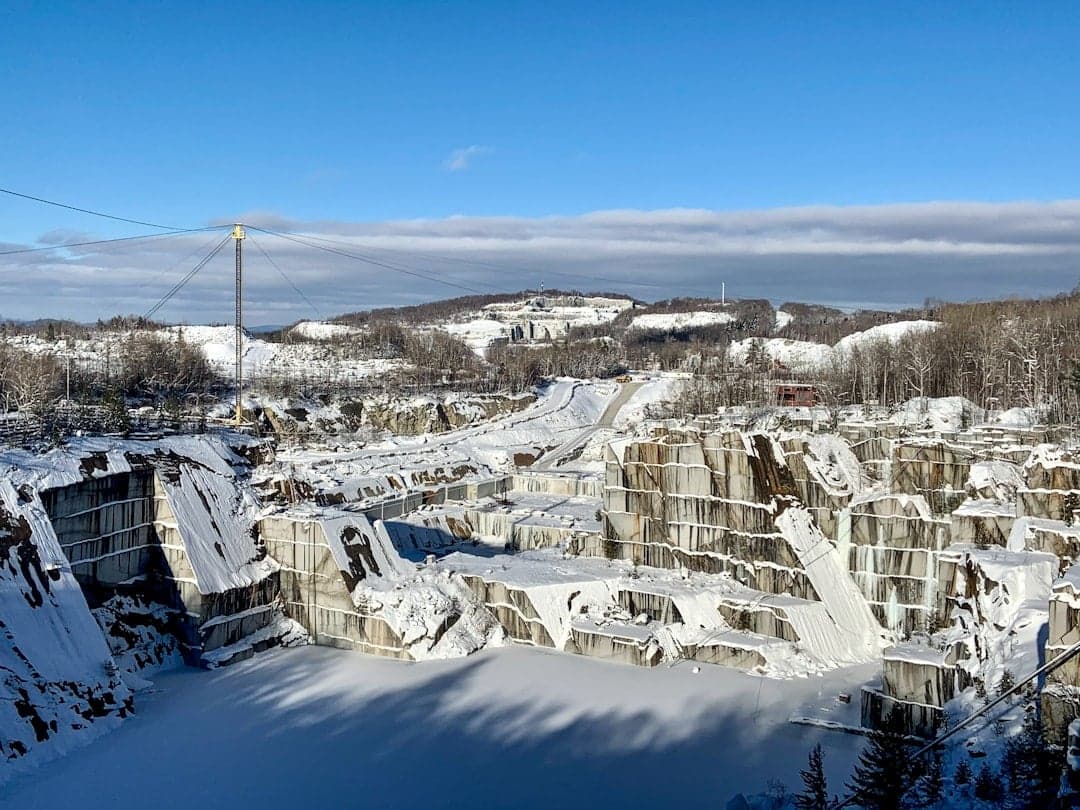
Barre sits in the Winooski River valley, cradled by the Green Mountains to the west and the Barre granite hills to the east. This topography provides natural chokepoints and defensible terrain. The city itself is roughly 45 miles from the Canadian border and about 40 miles from the New Hampshire line, placing it far from the coastal corridors (Boston is 160 miles south) and the I-89 corridor’s busier southern stretches. For a conservative-leaning relocator, this distance from major urban centers like Boston, New York, and even Burlington (only 45 minutes away) is a significant advantage. The area’s elevation—around 600 feet—keeps it above the worst valley fog and flood risks, while the surrounding forests offer ample cover and resources. The granite quarries that built Barre are not just historical artifacts; they represent a local expertise in hard rock and excavation, which could be leveraged for underground shelter or water storage. The region’s water supply is robust, fed by numerous streams and the Winooski River, and the area’s agricultural history means decent soil for small-scale farming in the valley bottoms. The climate is a genuine four-season affair, with cold winters that naturally deter transient populations and require serious preparation—a filter that keeps the unprepared away.
Risks, exposures, and proximity to fallout-relevant landmarks
No strategic assessment is honest without confronting the downsides. Barre’s primary risk is its proximity to Montpelier, the state capital, just 6 miles to the west. In a scenario of widespread civil unrest or a targeted attack on government infrastructure, Montpelier becomes a liability. State government buildings, the Vermont State House, and associated federal offices could draw attention. Barre’s working-class character might offer some obscurity, but it’s close enough to be affected by any chaos radiating from the capital. Additionally, the I-89 corridor runs through the valley, connecting Montreal to the north and Boston to the south. This highway is a double-edged sword: it provides supply routes but also a vector for displaced populations or military movement. The Vermont Yankee nuclear plant in Vernon (southern Vermont) is decommissioned, but the spent fuel remains on-site—a potential long-term contamination risk if compromised. Closer to home, the Barre-Montpelier Airport is a small general aviation field, not a major target, but it could be used for emergency logistics. The area’s granite quarries, while useful, also mean the ground is riddled with old mine shafts and unstable rock—a hazard for anyone digging without geological knowledge. Flooding is a real concern in the low-lying parts of the city near the Stevens Branch of the Winooski River; the 2023 floods demonstrated that even inland Vermont is not immune to extreme weather events. For the prepper, the key takeaway is that Barre’s risks are manageable with proper planning—unlike coastal cities, there’s no hurricane storm surge, and unlike the West, no wildfire or earthquake threat is significant.
Practical resilience for a relocator: food, water, energy, and defensibility
Barre’s practical resilience hinges on its existing infrastructure and community character. The city has a municipal water system sourced from the Berlin Pond and several wells, but a relocator should plan for a private well or rainwater catchment—the granite bedrock can make drilling expensive, but yields are generally adequate. The local power grid is served by Green Mountain Power, which has a mixed record on storm resilience; tree-covered lines mean outages are common in winter storms. Solar is viable, though winter sun is limited, and a backup generator with a propane or wood-gasification system is wise. Wood heat is the gold standard here—the surrounding forests provide abundant fuel, and many homes already have wood stoves. Food security is bolstered by the Central Vermont region’s strong local food network: farmers’ markets, CSAs, and small-scale producers are common. The Barre Farmers Market runs seasonally, and the city has several grocery stores (Hannaford, Shaw’s) that would be first to empty in a crisis, so building a deep pantry is essential. For long-term food production, the growing season is short (roughly 120 days), but cold-hardy crops and greenhouse use can extend it. Defensibility is a mixed bag: Barre’s downtown is dense and walkable, with narrow streets that could be barricaded, but the surrounding hills offer vantage points for observation. The city’s population of about 8,500 is small enough to foster a tight-knit community but large enough to have a police force and fire department. The local culture is heavily independent—many residents are hunters, anglers, and homesteaders. Gun ownership is common, and Vermont has some of the most permissive firearms laws in the country, which aligns with a prepper’s need for self-defense. The biggest practical weakness is the lack of a major medical center; the nearest hospital with a trauma center is the University of Vermont Medical Center in Burlington, 45 minutes away. For serious emergencies, that’s a long drive.
In the overall strategic picture, Barre offers a solid middle ground for the conservative relocator who wants to be out of the urban blast zone but not completely off the grid. It’s close enough to Burlington for specialized supplies and medical care, yet far enough to avoid the worst of a city’s collapse. The working-class grit of the town—its granite heritage, its no-nonsense residents—means you’re not moving into a wealthy enclave of weekenders; you’re joining a community that knows how to work with its hands and endure hard winters. The downsides are real: proximity to Montpelier, flood risk in certain zones, and a short growing season. But for someone serious about resilience, Barre’s combination of defensible terrain, water access, wood fuel, and a self-reliant culture makes it a strong candidate. It’s not a fortress, but it’s a damn good place to build one.
* Values derived from national, state, county, city and local statistics and may differ in a specific area. Last updated: 2026-04-22T22:58:48.000Z
Narrative content on this page is AI-generated and may contain mistakes. Verify any details that matter before acting on them.
ReloMaps may earn a commission from affiliate links at no extra cost to you.