
Photo: Wikipedia
Strategic Assessment of Bath, ME
Meaningful friction. Expect exposure to either population pressure, blast zones, or natural disaster risk. Consider buying a retreat property.
What does the Strategic Assessment tell us?
Our Strategic Assessment grades tactical survivability of an area. Major population centers, military targets, fallout zones, natural disasters, and border exposure all drive risk — lower exposure means a more defensible position in a crisis.
This is heavily inspired by Joel Skousen's Strategic Relocation book. Highly recommended you checkout the book ($)What does this tell us?
Our Strategic Assessment grades tactical survivability of an area. Major population centers, military targets, fallout zones, natural disasters, and border exposure all drive risk — lower exposure means a more defensible position in a crisis.
This is heavily inspired by Joel Skousen's Strategic Relocation book. Highly recommended you checkout the book ($)Strategic Pillars

Key Distances
Regional Safe Places
Below is our recommended "safe zones" in Maine and the surrounding area based on our strategic heuristics. For most people, it's unrealistic to live in a “safe zone” full-time due to work, family or other personal reasons. They tend to be more rural. However, many of these areas are perfect for second homes and retreat properties that double as a vacation home or even a short-term rental.


Important Note: For informational purposes only. This does not mean nothing bad ever happens in the green zones. Please use common sense. This is based on public data and modeled with AI. We tried to take a conservative approach but mistakes happen. We update this regularly as new information becomes available.
Solar Generator Recommendations
Backup power matters more here than in safer locations. We've picked three solar generators across budgets and capacity tiers — start with the budget unit if you only need a few essentials, or step up if you want to run a fridge and HVAC for days at a time.

Jackery Portable Power Station Explorer 300
Budget OptionPower on the Go: Weighing only 11 lbs, it's convenient to set up and store with book-sized foldable solar panels

BLUETTI Portable Power Station AC180
Designed for both indoor and outdoor scenarios, AC180 is highly capable as it has a robost capacity and continuous output power.

EF ECOFLOW DELTA Pro Ultra Power Station
Upgraded PickEcoFlow DELTA Pro Ultra is a whole-home energy system designed to grow with your family. Integrated with the Smart Home Panel 2, it scales to meet your evolving energy needs — keeping your home powered, intelligent, and secure through every stage of life.
We earn a commission, at no additional cost to you.
Strategic Assessment Analysis
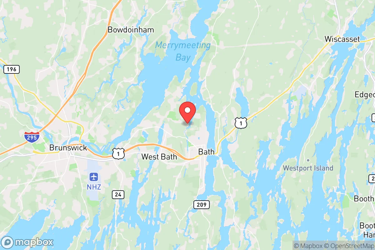
Bath, Maine, offers a surprisingly resilient position for those prioritizing strategic relocation, balancing coastal access with a buffer from the worst of urban collapse. Nestled on the Kennebec River about 40 miles northeast of Portland, this shipbuilding town of roughly 8,300 people provides a mix of industrial stability and rural isolation that appeals to a prepper mindset. Its location—far enough from Boston (150 miles) and Portland to avoid immediate fallout from a major event, yet close enough to tap into supply chains and medical infrastructure—makes it a credible base for long-term preparedness.
Geographic position and natural advantages for long-term security
Bath’s geography is its first line of defense. The Kennebec River provides a natural barrier to the west and south, while the surrounding Midcoast region is a patchwork of dense forests, tidal marshes, and working waterfronts. This terrain limits easy overland access from larger population centers, which is a key advantage if civil unrest or a mass casualty event triggers a mass exodus from cities like Portland or Lewiston. The area’s low population density—Sagadahoc County has about 36 people per square mile—means fewer competition points for resources during a crisis. Additionally, the rocky coastline and numerous islands offer potential retreat options by boat, a capability that most inland preppers lack. The region’s cold winters also act as a natural deterrent to transient populations, as harsh weather reduces the viability of prolonged outdoor survival for unprepared individuals.
Risks, exposures, and proximity to fallout-relevant landmarks
No location is without vulnerabilities, and Bath has several that demand attention. The most obvious is Bath Iron Works (BIW), a major U.S. Navy shipyard employing over 6,000 people. While BIW is an economic anchor, it’s also a high-value target in any conflict scenario—whether conventional war or asymmetric attack. A strike on BIW could produce secondary effects like chemical releases or structural collapse, and the facility’s proximity to downtown Bath (less than a mile) means a direct hit would devastate the town itself. Beyond BIW, the area sits within 100 miles of the Portsmouth Naval Shipyard in Kittery and the Maine Yankee nuclear waste storage site in Wiscasset (about 15 miles north). The latter, while decommissioned, still holds spent fuel in dry casks—a potential target for sabotage or a source of contamination if compromised. On the plus side, Bath is far from major interstate highways (I-95 runs 20 miles inland), which reduces the risk of being caught in a mass evacuation gridlock. However, Route 1, the coastal artery, could become a chokepoint if Portland or Boston empties northward. Flooding from storm surges is a real concern for low-lying areas near the river, and sea-level rise projections suggest parts of Bath’s waterfront could be underwater by 2050, complicating long-term defensibility.
Practical resilience for a relocator: food, water, energy, and defensibility
For a relocator serious about self-sufficiency, Bath offers a mixed bag. Water is abundant: the Kennebec River is a reliable freshwater source, though it requires filtration and treatment due to industrial runoff and tidal saltwater intrusion. Private wells are common in the surrounding towns (Woolwich, West Bath, Arrowsic), and many properties have access to springs or ponds. Food security is moderate. The growing season is short (May to September), but the region’s agricultural heritage means local farms, farmers’ markets, and community-supported agriculture (CSA) programs are plentiful. Deer hunting, fishing (striped bass, mackerel, and lobster), and foraging for mushrooms and berries are viable year-round activities. However, reliance on imported food is high—Maine produces only about 10% of its own food, so stockpiling is essential. Energy resilience is a weak point. The grid is aging and prone to outages from winter storms and nor’easters. Solar panels are a good investment, but the region’s cloud cover and short winter days reduce output. Wood heat is the most reliable backup, and many homes already have wood stoves or boilers. Propane is widely available but subject to supply chain disruptions. Defensibility is decent. Bath’s compact layout—a peninsula with limited road access—makes it easier to secure than sprawling suburbs. The river to the west and the Sasanoa River to the east create natural choke points. However, the town’s density (about 1,200 people per square mile) means that in a prolonged crisis, neighbors become either assets or liabilities. Building a network of trusted locals is as important as any physical barrier. The nearest major medical center is Mid Coast Hospital in Brunswick (10 miles south), which is adequate for routine care but would be overwhelmed in a mass casualty event. For serious trauma, Portland’s Maine Medical Center is the closest Level 1 trauma center, but that’s a 50-minute drive under ideal conditions.
The overall strategic picture for Bath is one of cautious optimism. It’s not a hardened bunker location, but it offers a realistic balance of isolation and access that many preppers overlook. The presence of BIW is a double-edged sword—it provides economic stability and skilled labor, but it also paints a target on the town. The real strength of Bath lies in its surrounding region: the Midcoast’s mix of forest, farmland, and coastline gives a relocator multiple options for retreat, resupply, and escape. If you’re willing to invest in off-grid capabilities (solar, well, wood heat, and a boat), and you can build relationships with the local fishing and farming communities, Bath can serve as a viable base for weathering the next decade’s uncertainties. Just don’t expect it to be a secret—the town’s reputation as a “hidden gem” is already fading, and property values are climbing. The window for affordable entry is closing, but for those who act now, Bath offers a defensible, resource-rich foothold in a state that still values self-reliance over government dependency.
* Values derived from national, state, county, city and local statistics and may differ in a specific area. Last updated: 2026-05-01T07:13:09.000Z
Narrative content on this page is AI-generated and may contain mistakes. Verify any details that matter before acting on them.
ReloMaps may earn a commission from affiliate links at no extra cost to you.