Photo: Wikipedia
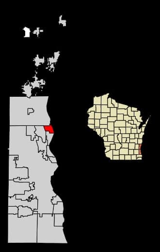
Strategic Assessment of Bayside, WI
Multiple tactical vulnerabilities. Population density, target proximity, or disaster risk are likely compounding. A retreat property and exit planning is required.
What does the Strategic Assessment tell us?
Our Strategic Assessment grades tactical survivability of an area. Major population centers, military targets, fallout zones, natural disasters, and border exposure all drive risk — lower exposure means a more defensible position in a crisis.
This is heavily inspired by Joel Skousen's Strategic Relocation book. Highly recommended you checkout the book ($)What does this tell us?
Our Strategic Assessment grades tactical survivability of an area. Major population centers, military targets, fallout zones, natural disasters, and border exposure all drive risk — lower exposure means a more defensible position in a crisis.
This is heavily inspired by Joel Skousen's Strategic Relocation book. Highly recommended you checkout the book ($)Strategic Pillars

Key Distances
Regional Safe Places
Below is our recommended "safe zones" in Wisconsin and the surrounding area based on our strategic heuristics. For most people, it's unrealistic to live in a “safe zone” full-time due to work, family or other personal reasons. They tend to be more rural. However, many of these areas are perfect for second homes and retreat properties that double as a vacation home or even a short-term rental.
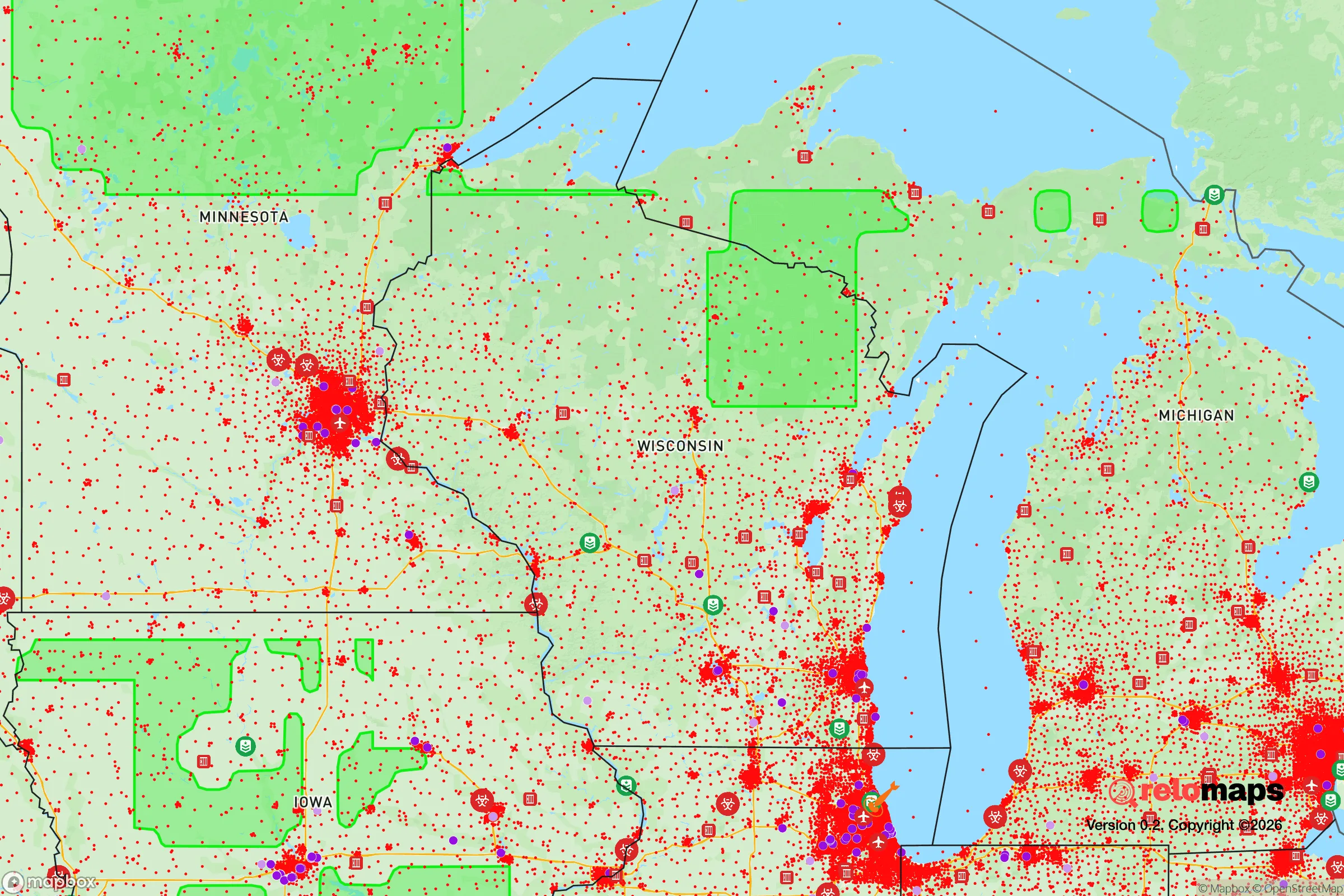
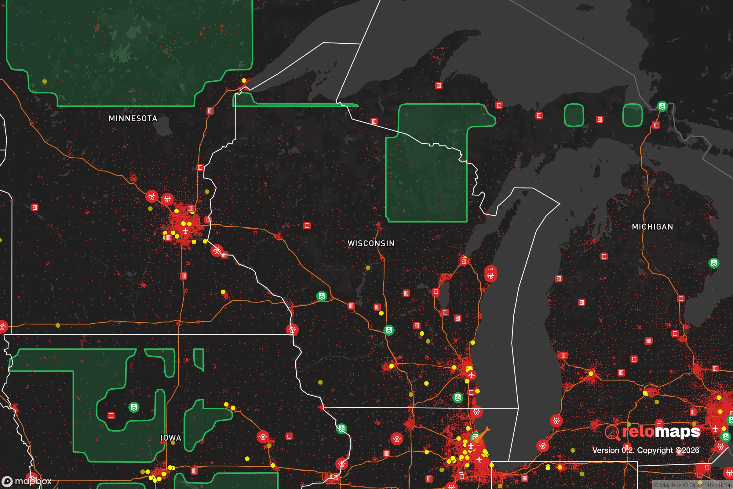
Important Note: For informational purposes only. This does not mean nothing bad ever happens in the green zones. Please use common sense. This is based on public data and modeled with AI. We tried to take a conservative approach but mistakes happen. We update this regularly as new information becomes available.
Solar Generator Recommendations
Backup power matters more here than in safer locations. We've picked three solar generators across budgets and capacity tiers — start with the budget unit if you only need a few essentials, or step up if you want to run a fridge and HVAC for days at a time.

Jackery Portable Power Station Explorer 300
Budget OptionPower on the Go: Weighing only 11 lbs, it's convenient to set up and store with book-sized foldable solar panels

BLUETTI Portable Power Station AC180
Designed for both indoor and outdoor scenarios, AC180 is highly capable as it has a robost capacity and continuous output power.

EF ECOFLOW DELTA Pro Ultra Power Station
Upgraded PickEcoFlow DELTA Pro Ultra is a whole-home energy system designed to grow with your family. Integrated with the Smart Home Panel 2, it scales to meet your evolving energy needs — keeping your home powered, intelligent, and secure through every stage of life.
We earn a commission, at no additional cost to you.
Strategic Assessment Analysis
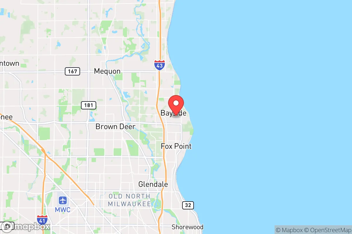
Bayside, Wisconsin, sits in a precarious strategic position that demands careful consideration for anyone serious about long-term preparedness. While its location on Lake Michigan offers certain natural advantages, its proximity to Milwaukee—roughly 12 miles north—and its position within the densely populated southeastern Wisconsin corridor introduce significant vulnerabilities for those prioritizing resilience against civic unrest, mass casualty events, or large-scale disasters. The village’s affluence and low crime rate are attractive on the surface, but a survivalist assessment must weigh these against the realities of being a potential evacuation destination for a major metropolitan area, with limited escape routes and close exposure to critical infrastructure targets.
Geographic position and natural advantages for long-term survival
Bayside’s primary strategic asset is its access to Lake Michigan, which provides a virtually unlimited freshwater source—a non-negotiable resource for any extended crisis scenario. The village sits on a bluff overlooking the lake, offering elevated terrain that could provide some natural defensibility and observation advantages. The surrounding North Shore suburbs form a relatively low-density residential corridor compared to Milwaukee proper, with tree cover and winding roads that could complicate rapid movement by large groups. The area’s proximity to the Interstate 43 corridor, however, is a double-edged sword: it allows for quick evacuation north toward Sheboygan or Green Bay, but it also funnels any south-to-north population displacement directly through Bayside. The village’s position within Ozaukee County, which consistently ranks among Wisconsin’s wealthiest and most conservative-leaning counties, suggests a population that may be more inclined toward self-reliance and community organization—factors that matter when formal systems fail. The lake moderates temperatures slightly, reducing extreme winter cold compared to inland areas, which could be meaningful for long-term heating fuel conservation.
Risks, exposures, and proximity to fallout-relevant landmarks
The most glaring vulnerability for Bayside is its proximity to Milwaukee, a city of roughly 570,000 that presents multiple threat vectors. Milwaukee’s industrial and port infrastructure, including the Port of Milwaukee and major rail yards, could become targets during geopolitical instability or domestic unrest. The city’s history of civil disturbances—including the 2020 riots that saw significant property damage and arson—demonstrates that unrest can spill into surrounding suburbs. Bayside is also within 30 miles of the Mitchell International Airport, a potential staging area for military or federal response operations that could draw unwanted attention. The village sits roughly 15 miles from the University of Wisconsin-Milwaukee campus and 20 miles from the Milwaukee County Research Park, both of which could be perceived as symbolic targets. On the energy front, Bayside is served by We Energies’ grid, which relies on a mix of coal, natural gas, and nuclear power from the Point Beach Nuclear Plant roughly 80 miles north. A catastrophic event at Point Beach—while statistically unlikely—would place Bayside within the 50-mile ingestion exposure zone, requiring potential evacuation or shelter-in-place protocols. The village’s evacuation routes are limited: essentially two north-south arteries (I-43 and Green Bay Road) and a handful of east-west connectors, all of which could become choked during a mass evacuation event.
Practical resilience for a relocator: food, water, energy, and defensibility
For a relocator serious about self-sufficiency, Bayside presents a mixed picture. The lake provides water, but treatment and pumping infrastructure would be vulnerable to grid failure. A well is not a realistic option for most properties due to the village’s municipal water system and lot sizes averaging under half an acre. Rainwater collection is feasible but limited by Wisconsin’s seasonal precipitation patterns and winter freeze. Food resilience is moderate: the village has no agricultural zoning, but nearby Ozaukee County has working farms within a 15-minute drive, and the Mequon Farmers Market operates seasonally. Long-term food storage would need to be planned for, as local grocery stores (Sendik’s, Pick ‘n Save) would deplete quickly in a crisis. Energy independence is achievable but requires investment—solar panels are permitted with village approval, but the tree canopy reduces generation potential. Natural gas is the primary heating source, which would fail without grid pressure. Defensibility is the weakest category: Bayside is a typical suburban layout with cul-de-sacs and interconnected streets, offering no natural chokepoints or terrain features that would slow a determined group. The village’s police department is small (roughly 10 officers), and mutual aid agreements with surrounding suburbs would be strained during a regional event. The best strategic play for a relocator would be to treat Bayside as a temporary staging point—close enough to lake resources and northward escape routes, but not a place to dig in for a long-term siege.
The overall strategic picture for Bayside is one of calculated trade-offs. It offers genuine advantages in freshwater access and a relatively stable, affluent community that would likely organize effectively in the early stages of a crisis. But its proximity to Milwaukee, limited evacuation routes, and suburban defensibility challenges make it a poor choice for anyone seeking a true retreat or long-term survival location. For the conservative-leaning relocator who must remain within commuting distance of Milwaukee for work or family obligations, Bayside is among the better options in the immediate metro area—but it should be viewed as a base camp, not a fortress. Those with the flexibility to move farther north, into the Kettle Moraine region or beyond Sheboygan, would gain significantly in terms of isolation, defensible terrain, and reduced exposure to urban fallout. Bayside works if you’re prepared to leave quickly; it fails if you plan to stay put.
* Values derived from national, state, county, city and local statistics and may differ in a specific area. Last updated: 2026-04-27T14:46:13.000Z
Narrative content on this page is AI-generated and may contain mistakes. Verify any details that matter before acting on them.
ReloMaps may earn a commission from affiliate links at no extra cost to you.