
Photo: Wikipedia
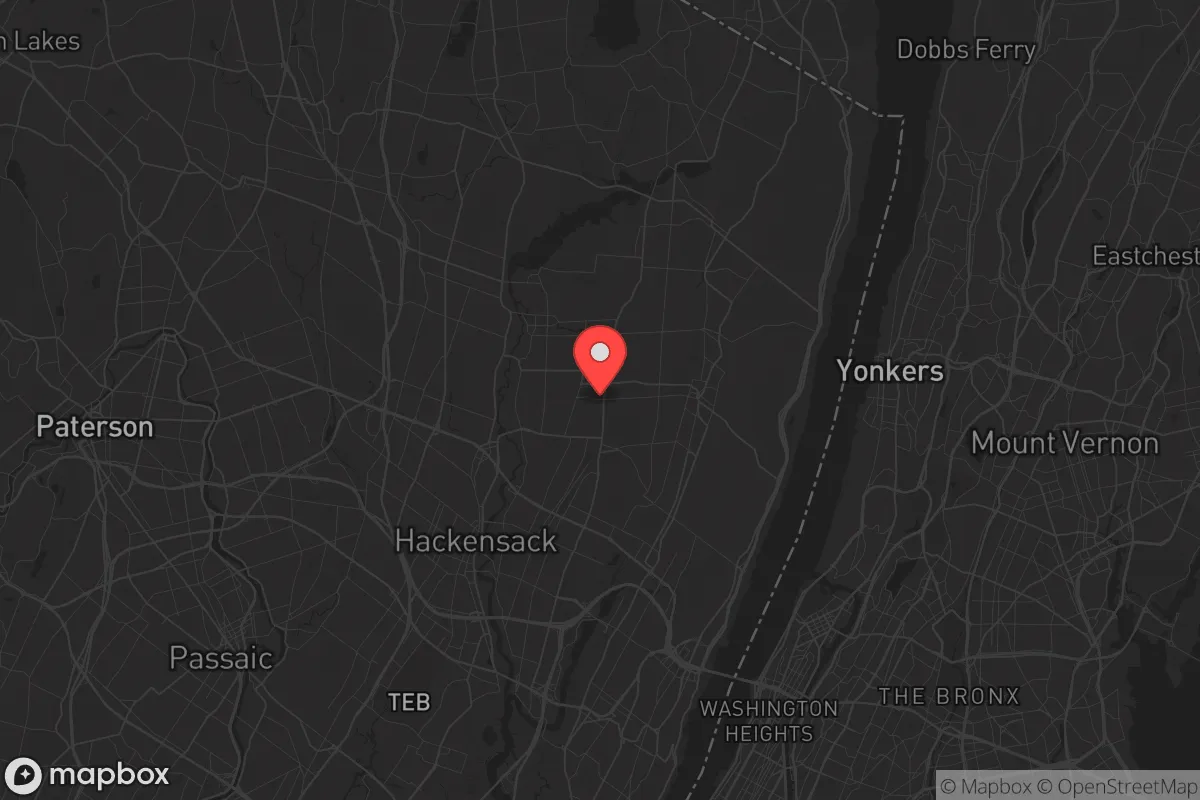
Strategic Assessment of Bergenfield, NJ
High tactical risk. This location is likely close to major population centers, strategic targets, or sits in a high-disaster corridor. A retreat property and careful exit planning is required.
What does the Strategic Assessment tell us?
Our Strategic Assessment grades tactical survivability of an area. Major population centers, military targets, fallout zones, natural disasters, and border exposure all drive risk — lower exposure means a more defensible position in a crisis.
This is heavily inspired by Joel Skousen's Strategic Relocation book. Highly recommended you checkout the book ($)What does this tell us?
Our Strategic Assessment grades tactical survivability of an area. Major population centers, military targets, fallout zones, natural disasters, and border exposure all drive risk — lower exposure means a more defensible position in a crisis.
This is heavily inspired by Joel Skousen's Strategic Relocation book. Highly recommended you checkout the book ($)Strategic Pillars

Key Distances
Regional Safe Places
Below is our recommended "safe zones" in New Jersey and the surrounding area based on our strategic heuristics. For most people, it's unrealistic to live in a “safe zone” full-time due to work, family or other personal reasons. They tend to be more rural. However, many of these areas are perfect for second homes and retreat properties that double as a vacation home or even a short-term rental.


Important Note: For informational purposes only. This does not mean nothing bad ever happens in the green zones. Please use common sense. This is based on public data and modeled with AI. We tried to take a conservative approach but mistakes happen. We update this regularly as new information becomes available.
Solar Generator Recommendations
Backup power matters more here than in safer locations. We've picked three solar generators across budgets and capacity tiers — start with the budget unit if you only need a few essentials, or step up if you want to run a fridge and HVAC for days at a time.

Jackery Portable Power Station Explorer 300
Budget OptionPower on the Go: Weighing only 11 lbs, it's convenient to set up and store with book-sized foldable solar panels

BLUETTI Portable Power Station AC180
Designed for both indoor and outdoor scenarios, AC180 is highly capable as it has a robost capacity and continuous output power.

EF ECOFLOW DELTA Pro Ultra Power Station
Upgraded PickEcoFlow DELTA Pro Ultra is a whole-home energy system designed to grow with your family. Integrated with the Smart Home Panel 2, it scales to meet your evolving energy needs — keeping your home powered, intelligent, and secure through every stage of life.
We earn a commission, at no additional cost to you.
Strategic Assessment Analysis
Bergenfield, New Jersey sits in a precarious strategic position that demands a clear-eyed assessment for anyone serious about resilience. Located just 12 miles from midtown Manhattan and embedded in the densely populated Bergen County, this borough of roughly 27,000 residents offers proximity to economic opportunity but carries significant exposure to the cascading risks that come with being a bedroom community of a major global city. For the conservative-minded relocator weighing long-term preparedness, Bergenfield presents a mixed picture: it is not a survivalist stronghold, but its specific location, infrastructure, and community fabric offer certain advantages that a disciplined prepper can leverage — provided they understand the trade-offs.
Geographic position and natural advantages for long-term preparedness
Bergenfield’s location in the Hackensack River Valley places it on relatively flat terrain, which simplifies construction and water management compared to more rugged areas. The borough sits about 70 feet above sea level, reducing flood risk from coastal storm surge — a meaningful advantage as Atlantic hurricane activity intensifies. The surrounding region is part of the Piedmont Plateau, with decent soil for small-scale gardening if you secure a property with yard space, though most lots are compact suburban parcels. The nearby Palisades cliffs, less than five miles east, provide a natural barrier that could slow movement from the coast inland during a crisis. More importantly, Bergenfield is within a 20-minute drive of the Ramapo Mountains and Sterling Forest State Park in New York, offering escape routes into less populated terrain if evacuation becomes necessary. The borough’s position along the Hackensack River also means surface water is accessible, though it requires filtration due to industrial runoff upstream. For a relocator prioritizing geographic defensibility, Bergenfield is not ideal — it lacks the isolation of rural Appalachia — but it does sit at the edge of a major urban zone, giving you a foothold near wilderness without being fully detached from supply chains.
Risks, exposures, and proximity to fallout-relevant landmarks
The most glaring vulnerability for Bergenfield is its proximity to New York City and the dense web of infrastructure that serves it. The George Washington Bridge, Lincoln Tunnel, and Holland Tunnel are all within 15–25 miles, meaning any mass evacuation or security event in Manhattan will send hundreds of thousands of people funneling through Bergen County roads. Routes 4 and 17, which border Bergenfield, become parking lots during normal rush hour; a crisis would make them impassable. The borough is also within 30 miles of Newark Liberty International Airport, a major transportation hub that could be a target for civil unrest or terrorist action. Additionally, the Indian Point Energy Center, a now-decommissioned nuclear plant 25 miles north in Buchanan, New York, still houses spent fuel in dry casks — a potential radiological hazard if compromised by a deliberate attack or natural disaster. On the positive side, Bergenfield is not near any active nuclear power plants, large military bases, or major chemical storage facilities, which reduces the risk of a direct industrial catastrophe. However, the broader New York metropolitan area is a high-value target for any adversary, and the cascading effects of a grid-down event, cyberattack, or biological incident would ripple into Bergenfield within hours. For the prepper, the key takeaway is that you are not in the blast zone, but you are in the disruption zone — and that requires a different kind of planning.
Practical resilience for a relocator: food, water, energy, and defensibility
Bergenfield’s suburban density works against self-sufficiency. Most homes are on quarter-acre lots or less, limiting space for large gardens, rainwater catchment, or livestock. The borough’s water supply comes from the Hackensack Water Company, which draws from the Oradell Reservoir — a single-point-of-failure system vulnerable to contamination or sabotage. A well is rare in this area, so a relocator should budget for a Berkey filter or similar gravity-fed system, plus at least a 30-day supply of stored water. Electricity comes from PSE&G, with overhead lines that are prone to failure during storms; a whole-house generator with a buried propane tank is a wise investment, as power outages from nor’easters and hurricanes can last days. Natural gas is available for heating and cooking, which is a plus for off-grid cooking if the grid stays up, but gas lines are vulnerable to seismic events or sabotage. Food storage is feasible — basement space is common in older homes, and the borough has several supermarkets within a two-mile radius, but those shelves will empty fast in a panic. For defensibility, Bergenfield is a mixed bag: the street grid is typical suburban, with multiple access points, making it hard to secure a perimeter. However, the community is dense enough that neighbors will notice unusual activity, and the borough has its own police department with a decent response time. A relocator should focus on low-profile preparedness — blending in, building a local network, and storing supplies without advertising them. The nearby Palisades and Ramapo Mountains offer bug-out options, but you need a vehicle with good ground clearance and a pre-staged cache to make that viable.
The overall strategic picture for Bergenfield is one of calculated risk. It is not a retreat for the hardcore prepper seeking off-grid autonomy, but it can work for a conservative-minded individual or family who wants to stay within commuting distance of New York job markets while maintaining a credible preparedness posture. The key is to treat Bergenfield as a base camp, not a fortress — invest in water filtration, backup power, food storage, and a reliable vehicle for evacuation, and build relationships with like-minded neighbors. The borough’s biggest weakness is its location in a high-density corridor that will be choked with refugees during any major event; its biggest strength is that it sits at the edge of that corridor, with wilderness options within a short drive. If you are willing to accept that you are living in the shadow of a major target, and you plan accordingly, Bergenfield can be a workable home base. But if your goal is true strategic depth — far from population centers, with land for self-sufficiency and natural barriers — you would be better served looking farther west into Pennsylvania or upstate New York. Bergenfield is a compromise, and in a world of increasing instability, compromises demand constant vigilance.
* Values derived from national, state, county, city and local statistics and may differ in a specific area. Last updated: 2026-05-02T02:22:37.000Z
Narrative content on this page is AI-generated and may contain mistakes. Verify any details that matter before acting on them.
ReloMaps may earn a commission from affiliate links at no extra cost to you.